Hammersley Fork

Cool read and good pics, thanks Bob. Just skimmed, but will read the whole thing later.

As for the stream, again, it’s largely fine once the old road grade leaves the valley floor...Between Beech Bottom and the Nelson confluence. Attempting to rectify the lower end, while still providing access to those camp owners will be nearly impossible to do, and prohibitively expensive. Just leave it alone. Anyone who wants that type of fishing experience is more than willing to walk the mile or so to get above the camps and the issues created by the road grade.
 
Never say never but I would find it doubtful that a real restoration project so expensive and with the attendant problems associated with the cabins as mentioned above would be implemented in a stream section like lower Hammersley. More environmental improvements to the chosen stream, Susquehanna River, and the Chesapeake Bay efforts would be associated with monies spent on at least partially agricultural streams in the Susq R Basin.
 
given the issues with at least part of hammersley's stream channel, a positive may be the huntley mountain bedrock area it heavily drains... at least over in sullivan, huntley seems to neutralize acid rain well:

"Water samples from the Burgoon Sandstone Member of
the Pocono Formation were the most acidic. The median pH of
water samples from the Burgoon Sandstone Member was 5.9;
from the Mauch Chunk Formation, 6.6; from the Catskill Formation, 6.9, and from the Huntley Mountain Formation, 7.0."
page 8 below

https://pubs.usgs.gov/sir/2013/5085/support/sir2013-5085.pdf

http://www.gis.dcnr.state.pa.us/maps/index.html
 
I'm certain the water's of good quality and ph Bob. Hammersley isn't a bug factory like a limestoner, but it's got a very diverse insect population. There's been evenings where I've seen Sulphurs, MB's, GD's, Yellow and Lime Sallies, Black Stones, and several types of Caddis hatching all at once...Not necessarily in huge numbers, but the typical good water quality freestone bug soup. Not that there were a ton of fish rising to them though.

I think Hammersley's "habitat problems" are overstated in this thread. The mile from the ford to a little above Beech Bottom, yeah, it's a mess. But other than that it's fine. It doesn't always fish well, but look at similar watersheds up in that part of the state...Slate and Cedar for example. Both of those have reputations of being very tough, especially in the low/clear conditions that are very common on these kinds of streams. Hammersley is no different. Check out klingy's recent post on Slate...
 
Mike wrote:
Never say never but I would find it doubtful that a real restoration project so expensive and with the attendant problems associated with the cabins as mentioned above would be implemented in a stream section like lower Hammersley. More environmental improvements to the chosen stream, Susquehanna River, and the Chesapeake Bay efforts would be associated with monies spent on at least partially agricultural streams in the Susq R Basin.

Agreed - there are far more environmentally damaged streams across the state that will attract attention and dollars, rather than creating some improved habitat on a freestone northern PA stream, that will benefit a few recreational anglers. I don't disagree that old railroad beds affect the flow of streams on many medium to larger size streams across the state, but the price to fix them would be astronomical, both in dollars and in short-term damage to get the equipment in to make changes.

There are definitely no 4-6' waterfalls on Hammersley or any of it's tributaries. The tallest I know is maybe a 3' tumble on Dry Hollow, which is usually nothing more than a moss-covered trickle most of the year. The thing about habitat is that it ebbs and flows. Streams change over time. Fallen trees that create good habitat eventually rot away or wash downstream in a deluge, only to be replaced at other places with other fallen trees. The stream course changes, sometimes for the good, sometimes for the worse. In the case of Hammersley, the road bed channel, particularly between Beech Bottom and the 3B's camp, is for the worse. Where Nelson Branch flows into Hammersley now is about 40-50 yards upstream from where it flowed into Hammersley just 15 years ago (used to be a large white boulder at the Nelson Branch mouth), and that mouth is well above the direct road channel influenced area. What I refer to as the Nelson Branch meadow (the area between Hammersley and Bell Branch) is a very active floodplain and the stream migrates across that floodplain every few years and seeks a new channel, sometimes finding one, and sometimes becoming very braided (although I think I can still trace the old railroad grade across that floodplain for a ways).

The trails and tracks above Beech Bottom have greatly diminished since the early 90's, when there was a clear trail to follow (and that was partially because vehicles could make it a good way up into the wild area). That vehicle trail is starting to get overgrown and the hiking trails that followed the stream now fade in and out, and are overgrown with saplings in some areas. Forestry service maintenance of a lot of the marked trails in that area took a tumble with state budget cuts, and I don't think maintenance in that area has ever been really restored. The Bell Branch trail is in pretty good shape, but the Nelson Branch trail is really rough in some areas.

Anyway, the stream meets the 80/20 rule for me; it's 80% good enough habitat-wise and scenery wise to make for an enjoyable outing.
 
Fished the Hammersley yesterday. Parking area at the ford had 4 vehicles. Don't know where those folks went, because I didn't see a sole on the stream, and I fished up well past Cow Run. I did see somebody got stuck going further back on those rutted "roads". Conditions were low and very clear, with water temp at 58F in the morning, and 61F when I left.

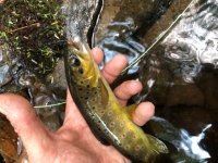
Caught 13 small trout. Three wild browns and 10 natives. All fish caught on dry/dropper. Royal Wulff Parachute up top, Copper John chartreuse on the bottom.
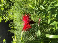
I was lucky to catch the Bergamot in full bloom. I look forward to seeing those beautiful flowers each year.
 

Attachments

  • IMG_0066 (Custom).jpg
    IMG_0066 (Custom).jpg
    118.6 KB · Views: 12
Wonderful story, wonderful fishing, make sure to harvest some bergamot leaves. Makes a great tea
 
Thanks Maxi. It's beautiful county up there. For whatever reason, if you click the pic it shows it rotated properly. There's a lot I don't understand with these new devices. :)
 
I fished Hammersly twice in the last 2 weeks. Parked at where the road crosses the stream and fished every drop from there. On the second trip the following week, fished where I left off previously. At the end, fading light, made it too what I think is Nelson where it splits. Just beyond a long flat pool with a very small gushing water trib joining in from the right. I covered water and fished it thoroughly even back-tracking to fish splits. In 2 days fishing, I caught 3 browns and a lot of brooks, especially the 2nd day fishing. This stream, which was my first fishing it, was such a delight. Colorful fish that dazzled the eyes imagination. Wary brooks that found refuge in deeper pocket water. Also, these fish were very picky brooks. They had to have a no drag drift or they refused to play. Such wonderful water and sights to take in. I'll be back to further the journey up ahead, for sure.
 
Yes, the Hammersley is a wonderfully beautiful stream. It is tough fishing when it's low, but they can be caught. I love just taking in the sights.
 

Attachments

  • IMG_0147 (Custom).jpg
    IMG_0147 (Custom).jpg
    143.3 KB · Views: 4
JJZ wrote:
I fished Hammersly twice in the last 2 weeks. Parked at where the road crosses the stream and fished every drop from there. On the second trip the following week, fished where I left off previously. At the end, fading light, made it too what I think is Nelson where it splits. Just beyond a long flat pool with a very small gushing water trib joining in from the right. I covered water and fished it thoroughly even back-tracking to fish splits. In 2 days fishing, I caught 3 browns and a lot of brooks, especially the 2nd day fishing. This stream, which was my first fishing it, was such a delight. Colorful fish that dazzled the eyes imagination. Wary brooks that found refuge in deeper pocket water. Also, these fish were very picky brooks. They had to have a no drag drift or they refused to play. Such wonderful water and sights to take in. I'll be back to further the journey up ahead, for sure.
The Nelson Branch comes in on the left side of the Hammersley going upstream.
 
I know, I just wrote that wrong. lol...
 
Some consider The Vanishing Trout as a worthy and great to read book! Now, if you asked the old timer about, Hammersley, Cross Fork nd Trout Run, he most off likely would have said, Close Them Off. In that way, Kettle will always have a supply of wild fish. Did the Old Timer in the book know something we do not till this day!

Think about it!
Would you still enjoy fishing if not fishing these streams.
I was there over 40 years ago and still adventure there! To know I am telling the truth up on Cross Fork along stream, someone has taken time to build stone tower monument and fire pit. I am kind of wondering if it is an offering to the God's, of what once was and probably will never be again! Get there! See all the beauty but remember, there was a time, a great time, when those streams, was a fly fishers fantasy!

Well, don't just sit there! "Get Movin". All that area, The Big Punch! Kettle, Little Kettle, Slider, Germania, Do it for me but most of all, do it for yourself! Up Trout Run to pinnacle of mountain, turn left, down Mt. to the Majestic Sinnemahoning! Yep! We did it again!

Maxima12
 
maxima12 wrote:
Some consider The Vanishing Trout as a worthy and great to read book! Now, if you asked the old timer about, Hammersley, Cross Fork nd Trout Run, he most off likely would have said, Close Them Off. In that way, Kettle will always have a supply of wild fish. Did the Old Timer in the book know something we do not till this day!

Think about it!
Would you still enjoy fishing if not fishing these streams.
I was there over 40 years ago and still adventure there! To know I am telling the truth up on Cross Fork along stream, someone has taken time to build stone tower monument and fire pit. I am kind of wondering if it is an offering to the God's, of what once was and probably will never be again! Get there! See all the beauty but remember, there was a time, a great time, when those streams, was a fly fishers fantasy!

Well, don't just sit there! "Get Movin". All that area, The Big Punch! Kettle, Little Kettle, Slider, Germania, Do it for me but most of all, do it for yourself! Up Trout Run to pinnacle of mountain, turn left, down Mt. to the Majestic Sinnemahoning! Yep! We did it again!

Maxima12

I've been to most of the places you mention, but have questions about a couple.

What does The Big Punch refer to?

And where on Cross Fork Creek is the "stone tower monument and fire pit?"

I've walked the entire length of Cross Fork Creek, but haven't seen that. Or maybe don't remember it!!

Is it near the stream or further upslope?


troutbert wrote:

And where on Cross Fork Creek is the "stone tower monument and fire pit?"

It can only be found by those who already know where it is.
 
Well, the big Punch, is what you have to do! Stand in the mirror and Punch yourself in the face. Time to go, if young you don't mind, if old, it is about the only thing you can do to get the mind working in the right direction. Long walk, most likely few fish, by yourself because you can't convince someone you age to go along. Lonely, you and nature and nature will eat you up. And at the end, you feel you accomplished something but no one else cares!

Cross Fork Temple to the Gods. It's only about 4 feet high, made of creek stones. But the way the stones are laid and fitted. A supreme example of youth. A beautiful fire pit adorns this site. Last year passing by a 5+ foot snakeskin decorated the monument! I hung around a while and started looking for gold or precious metals. Charred embers, a old can a piece of rope was there. And with out a doubt a big black snake was watching nearby! Fished a long way up to road and other cabins. No luck, apparently the snake scared no fishermen away! The days of fishing 1 to 2 miles is over, It's not the 2 miles, it's the 2 mile walk back. Gets me every time, so I take steps and count my steps to 50 then start over and over and over again.
 
Maxima,

This one is easier than the Cross Fork stone monument but do you know where the old fairgrounds was along Kettle. There is still a clue if you know where to look or know what you are looking at.
 
Prospector, No. I do not know. Fairgrounds on Kettle, Must have been fun. Good place to Metal detect

Maxima12
 
Swattie87 wrote:
troutbert wrote:

And where on Cross Fork Creek is the "stone tower monument and fire pit?"

It can only be found by those who already know where it is.

I think what Maxima might be referring to, is one of the campsites located right along the stream. About 4-5 hundred yards above the snow mobile bridge on the lower end of the creek.

Some people have piled up a bunch of flat rocks into some huge fire pits, tables, and I think even chairs to sit on.
It must have taken a lot of time and effort to haul all of that rock back there, and put it together.

Funny thing though - you can't drive to the site.
The DCNR has blocked off the old road into it with huge boulders

 
Dryflyguy, Seems he keeps his eyes open. Hats off to ya!
 
Back
Top