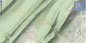
Google Map for all PA Wild Trout Streams!

I agree that the information age "ruins" the fun of you hard core brookie busters out there who use 15 maps, atlas', etc to find a new stream, but as it has been posted before, if people don't know about them, they don't get protected. I am of the "now" generation. I'm not one who texts all day long, or is always in front of technology, but I enjoy the end result, not the process to get there. It is a change in generations and yes at times it impedes on the "tradition" of the sport of fly fishing, which from a personal standpoint is not always a good thing. I think the sport is a good deal about tradition, but there are always new things that come along to make things better. I would hate to be slinging a silk line right now with a fly made of leather. Not that you can't still catch fish that way, but there are new and better things out there.
I don't think this map will put a lot of pressure on these streams, and if it does it will be a slight spike and then will tail off. (I'm a perfect example... checking out one later this week) It may put some rookies out there with the "purists", but to each his own... the original order of things will eventually work its way out. You will always have those guys who search high and low for new trout streams, and you will always have the guys who creel every stocked fish they catch. It is passed on from generation to generation for each technique. I have an office mate who I've talked to about fishing and he's a bait fisherman. I asked if he kept fish and he said he keeps just about every trout he possibly can. I won't share this link with him out of the protection of those spots, but I will share it with those I have brought up teaching fly fishing and take them personally to spots on the site and make them understand the importance of the wild trout populations in the state. It can be, like you said, both a good tool and a counterproductive one.


Ryan
 
Just an observation, not an argument (as I've found myself on both sides). This all seems counterintuitive to me.

Some guys enjoy putting in the effort to finding streams, and then guard their secrecy.

These are the guys who hate maps like this because it exposes the secret's they've found.

But shouldn't they be the ones who are fine with it, since they like putting in enough effort to finding new streams? Shouldn't it be the ones without secret streams who rejoice at such maps?

Chicken or the egg, I suppose. Personally, I don't think there is ANY new information here. The PFBC lists and google maps have always existed, as I said the GIS maps actually gave more information. This is just a little more user friendly, that is all.
 
"I think the sport is a good deal about tradition, but there are always new things that come along to make things better. I would hate to be slinging a silk line right now with a fly made of leather."

I agree, and many/most fisherman have probably always used the new stuff, whatever that was at the time, while others like retro stuff, like bamboo. You can do what you want.... I like new stuff - gps, satellite maps, satellite locator beacon for safety, whatever. I still know nothing about good stream sections compared to people with much more experience and none of that stuff, but maybe I can learn a bit faster using these internet maps. (still think I'd rather have a landis book than all PA sat-maps combined, tho)

But I think the thing that would _really_ change people's ability to find good trout holes hasn't come along yet ... if there was some super hi-res/thermal satellite map that would actually show you the size of holes on a tiny mountain trout stream right, through the trees? I haven't seen it! Please PM (!) me if someone has! 🙂
 
I once saw a fish rising on Google Maps, but by the time I got to the stream, the hatch was over. I can't wait for real-time streaming internet video of my favorite pools.
 
k-bob wrote:
But I think the thing that would _really_ change people's ability to find good trout holes hasn't come along yet ... if there was some super hi-res/thermal satellite map that would actually show you the size of holes on a tiny mountain trout stream right, through the trees? I haven't seen it! Please PM (!) me if someone has! 🙂

That would be Google Stream View. But I think its still in beta testing. 😎
 
The PF&BC has made the data available to generate these types of maps through PASDA for the past several years; I've been using it to generate my own maps since I figured out how to do it at the beginning of this year. Couple natural reproduction data with stream classification (particularly being able to map HQ and CWF class streams, which captures streams that the PF&BC has not surveyed) and you should get a good indication of streams that have or could support wild trout. Having this vast data stash available is almost overwhelming, and the streams still need fishing to test the hypothesis that they contain fish 🙂

While I'm not in favor of GPS coordinate, turn-by-turn directions to a honey hole, I'd venture this has little impact on the quantity of wild fish harvested. If someone wants to take the time to look up data online, and wants to target trout for meat that way, more power to them. I think there are far more accessible ATW for harvesting, that are closer and more visible to the general fishing populace than streams listed on the map, that may or may not still have a natural reproducing population of small trout.

Rather than being concerned about what someone else MIGHT do with the information that is available, maybe we should all be concerned about what we ourselves do with the information we already know about. Are we equally concerned about the companies behind the Marcellus play, knowing that the impact of that on trout vitality is potentially much larger than the PF&BC posting a map of naturally reproducing trout streams?

I tried the Microsoft equivalent of Google Stream View (Bing Waterway Traveler) but it kept returning brown streams, and then my computer crashed.
 
The map hasn’t worked in close to a week. I think the spot burner patrol hacked in and wiped the data clean! :-o

http://146.186.163.133/preview/map.ashx?layer=980
 
AFish wrote
The map hasn’t worked in close to a week. I think the spot burner patrol hacked in and wiped the data clean!

Too late. I've committed them all to memory. Ha ha ha!
:lol: :lol: :lol:
 
Its working again...
 
afishinado wrote:
The map hasn’t worked in close to a week. I think the spot burner patrol hacked in and wiped the data clean! :-o

http://146.186.163.133/preview/map.ashx?layer=980
I hate to dig up old stuff, but what's wrong with this Google map? You used to be able to click on any stream, and every trib to it, and get the name. What happened?
 
ryguyfi wrote:
I agree that the information age "ruins" the fun of you hard core brookie busters out there who use 15 maps, atlas', etc to find a new stream, but as it has been posted before, if people don't know about them, they don't get protected. Ryan


sorry, not buying it pal... exposure doesn't guarantee protection... elaborations if you so wish.

I am of the "now" generation. I'm not one who texts all day long, or is always in front of technology, but I enjoy the end result, not the process to get there. It is a change in generations and yes at times it impedes on the "tradition" of the sport of fly fishing, which from a personal standpoint is not always a good thing. I think the sport is a good deal about tradition, but there are always new things that come along to make things better. I would hate to be slinging a silk line right now with a fly made of leather. Not that you can't still catch fish that way, but there are new and better things out there. Ryan

I text all day long... we could exchange numbers maybe 🙂
No one cares about the "tradition of fly fishing... it's created a bad name for our sport imo, and the future will be about conservation, not macho attitudes.


I don't think this map will put a lot of pressure on these streams, and if it does it will be a slight spike and then will tail off. (I'm a perfect example... Ryan

you have no clue how many guests are viewing this forum right now do you? #OOPS#, I shared a few streams with some trusted friends, only to find them taking their friends, who take their friends, etc.

... butteryfly effect.
 
Jay, where's the Valium when you really need it? I'm looking for the answer to a simple question, not a lot of back and forth stuff on the subject. Thanks.
 
Meanwhile everyone that Bi*!?sabout spot burning just spot burned a bunch of streams.
 
wildtrout2 wrote:
afishinado wrote:
The map hasn’t worked in close to a week. I think the spot burner patrol hacked in and wiped the data clean! :-o

http://146.186.163.133/preview/map.ashx?layer=980
I hate to dig up old stuff, but what's wrong with this Google map? You used to be able to click on any stream, and every trib to it, and get the name. What happened?

Click on your link. In upper right hand corner is different ways to view the map. Choose Google Physical. Stream names magically appear.

As to the Valium question, Halupka needs longer half life. Klonopin FTW!
 

Attachments

  • maps.jpg
    maps.jpg
    543.1 KB · Views: 2
http://www.wildtroutstreams.com/

Check out this site.
 
Thanks jdaddy. I do that and get some stream names without even clicking them. But before, you used to be able to click ANY stream OR trib and get the name. This isn't the case now for some reason. Are YOU able to get the names of all streams and their tribs?
 
I had an idea that these maps were on the horizon, but this is the first that I have seen this feature. Admittedly, I have not "played" with them yet, but it seems to me that unless one has the Class A list in hand, or the Class A sections and Class B sections also highlighted in some way on the maps, an angler viewing the maps for the first time now knows where many wild trout streams are but has little idea of where the good populations are located. In fact, there is a lot of bad water shown on these maps from a fishing perspective. Remember, it only takes two trout of different year classes to put a blue line on these maps.

Tell me that you guys don't really think that the PFBC staff sits around thinking about license sales and then comes up with a project like this. This is a service project, not a license sale project. Now hear this: License sale discussions are about big picture items, not about things like maps.
 
tracker12 wrote:
So how do you get the name of the streams? Can't seem to figure that out.

You can get this same info in a KML file and load it into google earth. You then get a second file that has the stream names and load it at the same time.


Maybe not what you want to hear, but that's what I did. I'll post the links for the files tonight after work.

Kev
 
Back
Top