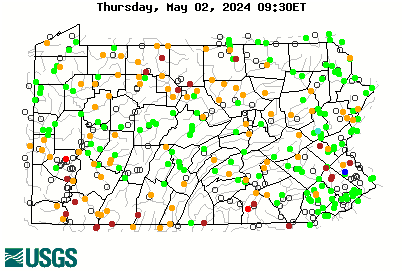
Not a pretty picture for the start of the season

Yesterday would have been the day to be fishing NC freestones, after the thunderstorms went through Tuesday night, the stream levels were real good for a brief time. That's the thing, timing. Gotta catch them during, or right after a rain. I missed this one!
 
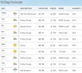
Appears that the north central counties will get a good soaker today and cooler temps are predicted in the upcoming days.

Will be interesting to hear some reports from folks in NCPA regarding what they see on their local streams this week.
 
There has certainly been a big change here in Central/Southcentral PA. The grass is green again and we've had some rain every day for the last 7 or 8 days. We had no rain for about 7 weeks. And I mean virtually none. The trout should be much happier now with some cool rainfall doing them good and the temps coming down. I imagine my local streams are sitting much, much better than they were in that 90+ temps and extreme drought that was here a few weeks ago.
 
That map sure looks better now. And BTW, July 2016 was the hottest month ever recorded.
 
Finally got a mix of rain and cooler temps. I'm not sure who's happier.....me, the fish or my A/C unit
 
Come on Hermine!! Come up the spine of the Appalachians and give us a good soaking.
 
Pcray, what are you seeing here. Looked like it was headed out to sea off Jersey but now I'm not so sure. At least the rain plume has shifted to the west side of the storm which improves our slim chance of rain. Northeast portion of the state has missed much of the rain over the last 2 months. A good soaker is in order but it appears to be just a wind event.
 
Kettle Creek at the village of Cross Fork - 10 cfs.

That's low.

Is the gauge above or below the confluence of Cross Fork Creek?
 
It's below. I was in Cross Fork today and drove up 144. I have never seen Kettle this low. There's been some rain, but it is so dry that the vegetation sucks it right up. IMO the only thing that will break the drought up here is about six feet of snow and a prolonged snowmelt this winter/spring.
 
Kray,

I was following it. I was in Hatteras (Outer Banks of NC, about as far down as it gets) on a family vacation, trying to decide whether to hunker down and ride it out or run like the ****ens.

btw, we chose the latter.

As for my take, if you followed the reports and models, it was always supposed to sit down and maybe wonder back towards the coast a bit. Which it's doing. A little farther north than expected. But still, it's gonna lash the immediate coast with heavy surf/light surge, maybe a bit of rain. Nothing Sandy-ish, just enough to inconvenience a few labor day week beach trips. But in PA all we get is a breeze from the north which brought in a fall-like feel. But it'll die out this week and we're going back to summer for another week or so.
 
Things haven't looked good in a while and don't appear to be improving anytime soon. Drought watch issued by DEP.

HARRISBURG, Pa. (WHTM) – The state Department of Environmental Protection has issued a drought watch for 34 Pennsylvania counties.

Officials are asking residents in those counties to voluntarily reduce non-essential water use by five percent.

Counties in south-central Pennsylvania are Berks, Dauphin, Fulton, Juniata, Lebanon, Mifflin, Perry, Schuylkill and Snyder.

DEP also issued a drought warning for Potter County. Residents there are encouraged to voluntarily reduce their water use between 10-15 percent.

Officials said the declarations were issued because of low stream flows, declining groundwater levels, and below-normal precipitation in the upper half and south-central portions of Pennsylvania.

They said the conditions have resulted in rainfall deficits of as much as six inches during the past 90 days.

DEP recommends the following ways to reduce water use:

– Run water only when necessary. Avoid running the faucet while brushing your teeth or shaving, or letting the shower run for several minutes before use;

– Check for household leaks. A leaking toilet can waste up to 200 gallons of water each day.

– Run dishwashers and washing machines only with full loads.

– Replace older appliances with high-efficiency, front-loading models that use about 30 percent less water and 40 to 50 percent less energy.

– Install low-flow plumbing fixtures and aerators on faucets.


Attachments

  • forecast.JPG
    forecast.JPG
    74.8 KB · Views: 4
The Gemmies just aren't cutting it gang. The water gods may need someone to step up and sacrifice a Brownie this time.
 
Looks like a good shot of storms are moving into NCPA and center state this afternoon and evening. Hopefully, it will slow down and rain for awhile.

We had over an inch of rain last night here in Gettysburg and eastern Cumberland County and this has really helped plump up the lower Breeches and Conodoguinet watersheds. Unfortunately, it was a very localized stom and it only helped a narrow and small area.

Things are looking better for this evening. C'mon rain!
 
It was very localized, unfortunately. Tonight looks more promising for sure. If we don't get a bunch more, the NC Summit and Catskills Jam will be staring at dry streambeds. I think Friday and Saturday both have some additional possibilities for rain. I'm crossing fingers for the low in the Atlantic to get more organized over the weekend......then need some luck for it to come on shore NC / VA region and ride up the Appalachians.
 
Kray, the one off the NE is dying and moving away. The one WAY out in the Atlantic is gonna form but cut up through the Atlantic and hit nothing but fishes.

So I assume you mean the little swirl off the leeward islands.

It's gonna come ashore around florida/georgia/SC I think, and head inland, then probably come up the apps or Ohio Valley eventually well over a week from now. The problem is I don't think it'll be much. It's not much now and has about zero chance of strengthening until the weekend when it'll only be a short window in favorable conditions before "landfall". It'd have to get it's act together real quick to even reach depression status. Then if it did come here it'd be after another week of weakening over land.

Lot of shear this year and tropical systems are struggling to get going so far. Hermine had to sit almost stationary over warm waters for nearly a week just to barely become a cat 1.

IMO it's more likely water will come with a good old jet stream trough bringing in a fall like cold front.
 
Coudersport just got hammered. Just need a few more hammerings...
 
I'm not giving up hope. 21 days to get tropical depression or multiple cold front gully washers.
 
Looks like another line of severe storms (now over the Mid-West) could role through the entire state tomorrow. Come on tornados!
 
Back
Top