interesting stream data

the ebfc report linked post 60 spells it out nicely, noting that swampy headwaters add acid and will increase aluminum. can see swampy headwaters in sat maps of course, and also usgs maps mark them well...

"One characteristic of acid waters is the presence of elevated concentrations of dissolved aluminum. Aluminum is the third most abundant element in the earth’s crust and under buffered soil conditions remains essentially immobile. Acid rain, however, can increase the mobility of aluminum and greatly increase the concentration transported into streams. The elevated levels of aluminum can be toxic to fish and other aquatic organisms; the collection of aluminum on their gills limits the intake of oxygen and other important nutrients." ...

"The concentration and speciation of aluminum in streams can vary, being dependent on the chemical composition of soils, geology, the pH of infiltrating water, and the presence of natural tannin-based (bog) acidity in the headwaters of a stream. The equilibrium concentration of aluminum in water is inversely proportional to pH below a pH of about 7 SU, such that as pH decreases aluminum concentrations increase. Aluminum concentrations also increase directly above a pH of about 9 SU, but this is seldom a problem in natural waters. The solubility increases dramatically below a pH of 4.5 SU, which is incidentally the approximate pH of acid rain in eastern Pennsylvania and East Branch Fishing Creek."

http://www.wehydro.com/images/2007fc.pdf
(emphasis added)
 
good background page 11 here:

http://swas.evsc.virginia.edu/publications/Current-and-Projected-Status.pdf
 
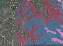
interesting map w/ unassessed small stream results, including streams w/o trout, below.

http://chesapeakeconservancy.org/SRFR
 
The links to the psu Schrader Creek study in this thread no longer work.. but if you put "Schrader Creek synoptic" in Google, an author has free downloads on the researchgate site.

Nice study; fig 13 shows how 4/10 small streams had alum of .2 mg/l or more 48 hours after hi flow (.2 mg/l alum for 48 hrs is lethal dose to brookies). 3 of these 4 streams had easily-measured elevated alum of .1 mg/l at low/base flows. all 4 had low brook trout numbers.
 
Fishing trips remind me that it is bedrock types, and not just elevation as it is loosely connected to bedrock types, that drives aluminum levels and brookie presence or absence.

For example, the image in post 10 shows that West Branch Fishing Creek tribs have more brookies than East Branch Fishing Creek tribs. So in brookie-trib fishing, why is the west the best? More of these WBFC tribs start in huntley bedrock, more of the EBFC tribs start in burgoon bedrock, see nice fig 2 here:

http://www.coldwaterheritage.org/docs/2010-grantees/fishing-creek.pdf?sfvrsn=2

And huntley buffers better than burgoon, usgs sullivan cty wellwater study: "The median pH of water samples from the Burgoon Sandstone Member was 5.9; ... and from the Huntley Mountain Formation, 7.0."

Thing is, these WBFC & EBFC tribs start at similar elevations. I think bedrock is generally associated with elevation, and bedrock is generally lower buffering up high, but it can be bent. Bedrock folds may lead to some mountain streams with good brookies only miles away from other mountain streams without trout...

Maybe I will study bedrock maps and not "climb every mountain..." 🙂
 
image from WV below, for low-buffering Tuscarora bedrock, makes the point that the same bedrock can appear at different elevations in one area.

https://mountainbeltway.files.wordpress.com/2010/03/gvoverlook1.jpg?w=468&h=517
 
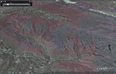
the WBFC tribs aren't at a different elevation than the EBFC ones; they are just in different bedrock (red = Huntley, blue = burgoon).

(note elevation exaggeration turned up in google earth)
 

Attachments

  • fcs4.jpg
    fcs4.jpg
    143.8 KB · Views: 5
Map to show that small tribs at the same elevation can have different bedrock geology. Map is EBFC/WBFC area with terrain exaggerated to suggest drainage boundaries and a blue dot where each trib is at about 2200 ft. blue bedrock is burgoon, red is huntley; see previous post on well water pH in sullivan, huntley buffers better (recall that pH is log scale).

Map suggests that bedrocks don't always just cut straight across elevations. The WBFC tribs w/ huntley bedrock headwaters are more fishy than the EBFC tribs w/ more burgoon headwaters, even though the WBFC & EBFC tribs start at similar elevations.

This stuff is much easier to do in NEPA than in parts of the ridge and valley area (say parts of centre county) where at least according to wikpedia "The rocks here are severely folded and contain nuimerous anticlines and synclines that plunge and fold back over each other. There are numerous thrust faults that help create a chaotic mess." In NEPA and NCPA there are bigger expanses of say Huntley, Catskill, or Mauch Chunk bedrock that may be more fishy than nearby Pottsville, Alleghany, or Burgoon areas.
 

Attachments

  • fcs13.jpg
    fcs13.jpg
    146.6 KB · Views: 5
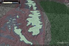
Schrader creek tribs... here elevation (blue dots @ 1700 ft) is a better indication of the change from Huntley (red) to Burgoon (blue).

But many of the tribs on the north/right in image have Pottsville or Alleghany bedrock in headwaters (green). Pottsville is very low buffering and has some coal, so some of the tribs on the north may have a negative double whammy of acid precip and AMD effects from old mines.
 

Attachments

  • sc1.jpg
    sc1.jpg
    134.3 KB · Views: 5
nice discussion of pH and dissolved aluminum for lycoming creek tribs, slides 19-26:

http://slideplayer.com/slide/5119574/

as in the schrader area, some of these tribs may have a double whammy of both low buffering pottsville/alleghany headwaters bedrock, and old mines that may exist in areas of this bedrock.

some of the tribs w better pH & Al (bottle run and beauty run) are in higher buffering catskill bedorock... the lower levels of little gap and hoagland are also in catskill...
 
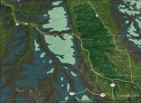
Some of the Lycoming tribs from the slide deck in post 70 with the worst aluminum levels are in the McIntyre wild area. This wild area includes the green Pottsville/Alleghany bedrock area between Ralston and Leolyn in the image below.

These high-aluminum tribs include abbott run, miners run, and hound run. (see slide 23, recalling that .2 mg/l Al for 2 days is lethal to trout). Pottsville/Alleghany is low buffering and coal bearing, so sometimes mined...

(as in previous google earth images, terrain exaggerated to show watersheds)
 

Attachments

  • rr3.jpg
    rr3.jpg
    127.6 KB · Views: 7
An example of a mountain stream that I may not try due to bedrock is Browns Gap Run in State Game Land 99 east of Raystown Lake. It drains a small area of land, looks very steep, may have access without too bad of a hike. However, its headwaters are in Tuscarora bedrock, low buffering and associated with elevated aluminum. So while it is on the reproduction list, I would guess that it doesn't fish very well up that mountain ... anyone ever try it?
 
Bob,

I'd argue that some of the streams you are discussing as "poor" buffering would be the most interesting to monitor for past vs. present vs. future.

I don't disagree with your method.

But on another thread I highlight the rise in pH of rainfall all over the state. Fairly impressive changes in the last couple of years which are still ongoing.

A good question is how much of the geology you are looking into is "buffering" vs. "root cause". If it's buffering, the acid rain is the real underlying problem, the geology just determines how much damage it causes. But the rising pH of rainfall may lead to substantial improvements in some of these "poor" streams.

If it's the root cause, then the acid is coming from the rock, not the rain, and it ain't gonna make much difference.

I'd guess it's a mixed bag and every situation is different.
 
Browns Gap Run looks too small, IMHO, just looking at the map. There is very little drainage area.
 
Pat I agree, would like longitidinual info, and sometimes bedrock, such as coal bearing Pottsville, may both buffer poorly and possibly leach acidity from its interaction with water.

Dwight yeah I don't have records with me, I'm traveling, but I think that little Browns Gap run drains about one half a square mile? It looks steep enough, maybe seven eight percent grade, that I suspect it would have some pools and could have trout if it were coming out of Huntley, Mount chunk, Catskill. Juniata, or Shawangunk bedrock. Definitely most people do not fish streams that small. I like hiking, would give that it a go if the bedrock were different. As the Kirby paper, where you were one of the anglers showed, Tuscarora bedrock is low potential.

 
Pat I agree, would like longitidinual info, and sometimes bedrock, such as coal bearing Pottsville, may both buffer acid depo poorly and possibly leach acidity from its interaction with water. For example in areas like that it can be hard to separate an AMD effect from an acid rain effect.

Dwight yeah I don't have records with me right now, but I think that little Browns Gap run drains about one half a square mile? It looks steep enough, maybe seven eight percent grade, that I suspect it would have some pools and could have trout if it were coming out of Huntley, Mount chunk, Catskill, Juniata, or Shawangunk bedrock. Definitely most people do not fish streams that small. I like hiking, would give it a go if the bedrock were different. As the Kirby paper, where you were one of the anglers showed, Tuscarora bedrock is low potential. But tuscarora is often near Juniata Bedrock which is high potential

There's some nice things online from susquehanna u showing that White Deer Creek tributaries that drain small amounts of land and are in Juniata Bedrock have some wild brookies but yeah the streams are tiny.
 
examples of streams w smaller drainage that have brookies... tend to be in juniata bedrock, not the tuscararora also in area...

https://www.susqu.edu/Documents/fri/2014-ressler-landscape.pdf
 
on small drainage areas: slide 14 below, in the charts for number adult brookies & biomass, suggests that about .5 sq mi is a decent drainage cutoff for a stream to have brookies:

http://www.coldwaterconference.com/uploads/5/0/9/0/50909909/ressler.pdf

Id try a stream that drains .5 sq mi if the bedrock seemed good and it was steep and forested. but again I will fish tiny streams.
 
nice article on variable bedrock buffering of acid rain in MA:

http://troutstreamdaydreams.blogspot.com/2016/05/geology-best-fertile-trout-stream.html

in PA, we have some areas of such low buffering bedrock that the issue is trout/ no trout, more than how much trout biomass

'accidents of geology cause some streams to be well buffered and invulnerable to acid rain, but others are poorly buffered and sensitive to even small acid loads. Decades of acid deposition has depleted the original buffering capacity of many headwater streams. Acidic streams are all too common. The southeast portion of the Allegheny National Forest is especially hard-hit. Our recent sampling of the Millstone Creek, Spring Creek, and Bear Creek watersheds shows that eight of 35 headwater streams sampled have summer baseflow pH < 5.0 and contain no fish.'

(patu article on raven run in anf)
 
Top