You are using an out of date browser. It may not display this or other websites correctly.
You should upgrade or use an alternative browser.
You should upgrade or use an alternative browser.
interesting stream data
- Thread starter k-bob
- Start date
k-bob
Well-known member
- Joined
- Jul 29, 2009
- Messages
- 2,376
I revisited some old PAFF threads on AMD. There is a great post by PAGeologist pointing out, among other things, that heavily toxic aluminum is often not visible in streams. (For ex., the stream with the lethal level of alum, first image post 34, had orange coating on rocks, not white.) He also noted that alkaline abandoned mine drainage can have toxic metals, just like acid mine drainages can.
PAGeologist suggested that the consequences of AMD for trout can differ depending on the bedrock streams flow through:
PAGeologist: "Sometimes, a stream will have a "dead zone" where all the metals drop out and acidity is released, where there is virtually no life in it. But it returns to a viable trout stream further downstream. Typically this will occur where the AMD is a small portion of the overall stream flow and the stream has a high buffering capacity to neutralize the acidity." (emphasis added)
PAGeologist also wrote in another post: "AMD and acid rain will remain and impact streams until the water contacts either a rock/soil formation or another water body that can raise the pH."
Some mining areas (schuylkill) are in low buffering Pottsville geology, but have nearby regions of higher buffering mauch chunk geology. With or even without treatment of a headwaters amd input, a stream may be more likely to have a downstream zone with trout if it flows through (or gets tribs from) areas with higher buffering bedrock. The AMD input could even lower the water temps in some cases.
k-bob
Well-known member
- Joined
- Jul 29, 2009
- Messages
- 2,376
(state report on the Lehigh)
"Toxic metals, such as aluminum, can be leached from the soils and delivered to the lakes and streams by acidic rainfall. For example, small amounts of dissolved aluminum can cause mortality in fish by
damaging their gills and decreasing sodium in their bloodstream. Finally, fish eggs and fry are very susceptible to high acidity and toxic metals. Partial or entire year classes can perish, leaving
older, more resistant individuals to maintain a remnant population."
reminds me of a comment from Mike here that some of the bigger trout he sees are in AMD streams.
k-bob wrote:
(state report on the Lehigh)
"Toxic metals, such as aluminum, can be leached from the soils and delivered to the lakes and streams by acidic rainfall. For example, small amounts of dissolved aluminum can cause mortality in fish by
damaging their gills and decreasing sodium in their bloodstream. Finally, fish eggs and fry are very susceptible to high acidity and toxic metals. Partial or entire year classes can perish, leaving
older, more resistant individuals to maintain a remnant population."
reminds me of a comment from Mike here that some of the bigger trout he sees are in AMD streams.
^ Now that's a statement/theory that never occurred to me. Interesting.
k-bob
Well-known member
- Joined
- Jul 29, 2009
- Messages
- 2,376
k-bob
Well-known member
- Joined
- Jul 29, 2009
- Messages
- 2,376
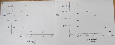
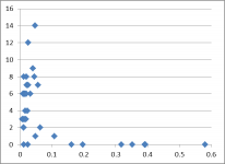
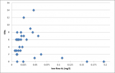
... McInerney data with the stream stretches that had AL > .20 deleted (all were 0 trout) to clarify the low levels of Al associated w/ trout presence & numbers. revealing that McInerney had a large battery of lab water testing info and focused on aluminum...
Attachments
k-bob
Well-known member
- Joined
- Jul 29, 2009
- Messages
- 2,376
With info on many water chem variables available, McInerney's conclusion emphasizes the role of aluminum (p 38):
"Brook trout can also be used as a reasonable indicator of a headwater stream’s ecological health and stream chemistry. A reasonable inference to be made in any headwater stream throughout the Valley and Ridge Province in Pennsylvania where
brook trout are absent is that this stream of interest is indeed impaired by acid deposition, has a large dissolved aluminum concentration and very little, if any, alkalinity."
If the absence of brookies indicates higher aluminum, lower aluminum may signal their presence.
(btw, pH may not be a strong proxy for aluminum. McInerney's shawangunk streams had a mean pH of 6.0 at low flow, which doesn't sound too promising. But they had the lowest aluminum, and 7/7 Shawangunk streams had brookies.)
k-bob
Well-known member
- Joined
- Jul 29, 2009
- Messages
- 2,376
given the test range, 0-.3 mg/l aluminum, this may be of use on those long drives in the mountains... grab some water samples where streams cross roads before bushwhacking up one of them.
http://www.coleparmer.com/Product/Aqua_Comparator_Test_Kit_Aluminum_0_0_3_mg_L/EW-05542-31#Specs
http://www.lovibondwater.com/product/checkit-comparator-aluminium.aspx
http://www.coleparmer.com/Product/Aqua_Comparator_Test_Kit_Aluminum_0_0_3_mg_L/EW-05542-31#Specs
http://www.lovibondwater.com/product/checkit-comparator-aluminium.aspx
k-bob
Well-known member
- Joined
- Jul 29, 2009
- Messages
- 2,376
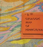
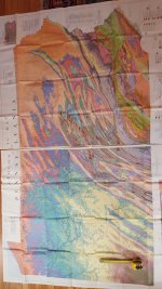
You sometimes see large paper maps of Pennsylvania bedrock geology on eBay or Amazon for $10 to $40 ... the 1980 Geologic Map of Pennsylvania, published by the state, is very good, shows roads and streams. May be better than dealing with all this info on a phone or GPS screen (those are better to use walking to and along chosen water). Large map each half of state is perhaps 3'x4.5' . Head for the mauch chunk, avoid the pottsville and tuscarora...
Attachments
k-bob
Well-known member
- Joined
- Jul 29, 2009
- Messages
- 2,376
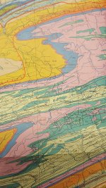
Here's a 1960 pa bedrock map. Turquoise in NWPA is low buffering pottsville, for ex., and salmon in NEPA is better buffering catskill. The coffee-colored squiggle across the ridges (for ex. SE centre cty) is tuscarora, which will tend to have high aluminum and suppresed trout. The 1980 map (orange folder) is more detailed, but this 1960 one (green folder) sometimes on eBay as well. The DCNR map online has this info, but these big paper maps may be better than small phone or GPS screens when choosing stream areas from a car.
Attachments
k-bob
Well-known member
- Joined
- Jul 29, 2009
- Messages
- 2,376
Yeah I have the usgs pa bedrock layer for Google Earth, great for planning trips from home. But I like these big paper maps when I am driving round an area with a lot of streams. As far as I can tell, the 1980 pa bedrock map in large paper format has the same info as the online dcnr map or the usgs Google Earth layer. The 1960 paper one is much less detailed.
I have put some PA bedrock maps on my etrex gps but these big bedrock maps don't work too well IMHO on small screens. May try my phone but it's not as grippy to hold as the gps, don't like to use it on hikes or streams.
I have put some PA bedrock maps on my etrex gps but these big bedrock maps don't work too well IMHO on small screens. May try my phone but it's not as grippy to hold as the gps, don't like to use it on hikes or streams.

k-bob
Well-known member
- Joined
- Jul 29, 2009
- Messages
- 2,376
shaner the image in post 10 uses the google earth pa bedrock layer offered by usgs. (I tweaked the google earth bedrock colors to be more like the state maps, so I don't have to recognize two sets of colors.) google earth can get streams, public land boundaries, and bedrock all in one image. (for example, the black lines in the image in post 10 are the sgl boundaries). a paper nat geo pa recreation atlas + the big 1980 state bedrock map has this info when driving around. google earth is great to plan from home.
I assume my newish android phone could have google earth w/ public land boundaries, a satellite map, stream listings (class a and nat repro), and bedrock, just link the image from my desktop in post 10. but with little and sometimes no cell service out fishing, I dont know if it would get location info from satellites as well as my garmin etrex does. also afraid I'd drop it in water 🙂
I assume my newish android phone could have google earth w/ public land boundaries, a satellite map, stream listings (class a and nat repro), and bedrock, just link the image from my desktop in post 10. but with little and sometimes no cell service out fishing, I dont know if it would get location info from satellites as well as my garmin etrex does. also afraid I'd drop it in water 🙂
k-bob
Well-known member
- Joined
- Jul 29, 2009
- Messages
- 2,376
TB, two quotes on huntley bedrock, which can be good in the NEPA places I tend to fish...(put quotes in google to get sources)
TU study of trout run, clearfield: "The Burgoon and Huntley Mountain strata contain a greater percentage of shale and siltstone than the basal Pottsville Group, and are described in some localities as having calcareous interbeds. It is presumed that the streams with significant reaches rooted in these units will benefit somewhat from this inherent alkalinity."
Sullivan cty usgs wellwater study: "The median pH of water samples from the Burgoon Sandstone Member was 5.9; from the Mauch Chunk Formation, 6.6; from the Catskill Formation, 6.9, and from the Huntley Mountain Formation, 7.0."
k-bob
Well-known member
- Joined
- Jul 29, 2009
- Messages
- 2,376
some nice articles on regional differences in one bedrock type across PA... I almost never fish swpa, just too far for me, but this seems interesting.
"In the southwestern corner of Pennsylvania, the Mauch Chunk is interbedded with limestones such as the Loyalhanna, Wymps
Gap, Reynolds and Deer Valley (Brezinski, 1999)."
"In the southwestern corner of Pennsylvania, the Mauch Chunk is interbedded with limestones such as the Loyalhanna, Wymps
Gap, Reynolds and Deer Valley (Brezinski, 1999)."
k-bob
Well-known member
- Joined
- Jul 29, 2009
- Messages
- 2,376
the best geology maps for the car might be the Atlas of Preliminary Geologic Quadrangles of PA, Berg and others, about 1981, big book/binder of black and white maps. psu has some of these maps online. maps seem to be usgs topos with bedrock areas mapped and listed, so they also show elevation, roads, etc. ... sample below:
https://web.archive.org/web/20070715213812/http://www.dcnr.state.pa.us/topogeo/map61/sybertsville.pdf
https://web.archive.org/web/20070715213812/http://www.dcnr.state.pa.us/topogeo/map61/sybertsville.pdf
k-bob
Well-known member
- Joined
- Jul 29, 2009
- Messages
- 2,376
Have done some NEPA fishing with alum test kit. As noted, aluminum is a better predictor of trout mortality with acid precip/rain than pH. Bedrock geology is a useful signal of stream aluminum levels that you can get from a map. For example, in Sullivan county, burgoon is a bad sign, and catskill or huntley a better sign, but there can be variation w/in a bedock band due to soil differences (see quote below).
Striking to see the aluminum differences in nearby streams that look the same. I checked two parallel tribs, .5 mi apart, to one small Sullivan county stream at moderate flows. The first trib had .15 alum (3/4 of the lethal level) and burgoon bedrock: won't even be brookies at that level. The second trib was in huntley, had no alum at all, and had both brook and brown trout.
Interestingly, alum levels associated with bedrock and soils will sometimes lead to worse fishing as you climb higher up a mountain -- the streams up high may start or stay in burgoon or Pottsville. You may be hiking into areas with higher gradient, better pools, lower fishing pressure, and less fish. Not that I have ever done it 🙂
"The general pattern observed for the watershed is that higher degrees of acidification tend to correlate with higher elevations, corresponding to the Burgoon Sandstone. The lowermost reaches floored by the Catskill Formation show the best water quality. The better conditions in the lower main stem of East Branch Fishing Creek are also associated with the less acidic Barbour soil series. There is insufficient overall correlation to definitively point to any one geologic unit as being the source of the acidification problems. Because of the consistently strong aluminum response to flow throughout the watershed, it is interpreted that runoff acidification is primarily related to systemic soil acidification and not a particular bedrock component."
http://www.wehydro.com/images/2007fc.pdf
somewhat blurry images, but some nice bedrock maps here:
https://www.libraries.psu.edu/psul/emsl/paresources/paprelimquadmaps.html


