interesting stream data

k-bob

k-bob

Well-known member
Joined
Jul 29, 2009
Messages
2,371
May have been on PAFF before, but if you use the graph tab on the page below, choose streams and a measurement w/ dates, you can see how warm the upper loyalsock got last summer, the pH of kitchen and east branch fishing creeks over time, etc

http://mdw.srbc.net/remotewaterquality/data_viewer.aspx

same org has some nice addl data here:

http://mdw.srbc.net/waterqualityportal
 
one trick to this page (the second one in OP):

http://mdw.srbc.net/waterqualityportal

if you reverse the order of the 2 geographic coordinates given for each survey site, and paste them into a google map, it will display the survey site location. (there is a map link, but it hasn't worked for me)
 
Example 1 year of pH data for class a kitchen creek, and also the nearby east branch fishing creek. Kitchen creek's pH ranges from about 6-7.4, often in the sixes, moving with precip effects (rain, snow, snowmelt). The greater acid rain impact on EBFC is seen in its pH range from about 4.9-6.2, often in the fives. Streams are only about 5-7.5 mi apart; pH difference connected to the headwaters geology of streams and their tribs. Lowest pH appears to have been on a (warm) Dec25 '14, snowmelt.
 

Attachments

  • zawewr.jpg
    zawewr.jpg
    103.7 KB · Views: 6
Interesting that the pH pretty much rises and falls at the same times for each stream, save for the late July spike downward on EBFC. Maybe a localized thunderstorm?
 
Yes, precip events. In spring/summer, it can be pretty localized.

On a longer term, you will also notice a periodicity in pH by season. Somewhat evident in that graph in that the pH trendline peaks in about August, falls all fall, bottoms out in January, then rises all spring into summer. It becomes more evident if you increase the timeline on the X axis. It's a common pattern of freestoners.

Reasoning: % of the flow from groundwater vs. recent precipitation. In August, streamlevels are low, but it's mostly groundwater. In January, streamlevels are higher, but with frozen ground it's mostly snowmelt or direct runoff. Groundwater has a higher pH.

And of course, large precipitation events increase the % of flow from runoff, hence the sudden but temporary pH drops.
 
have to remind myself that pH is a logarithmic scale, so 5 = ten times the acidity of 6.
 
they have some one-day data on EBFC tribs in second page linked in OP; gnarly pH levels include 4.2 on a swampy UNT to Meeker Run.
 
image below is EBFC on right and WBFC on left. nat repro in green stream lines; class a in blue stream lines. background geology color is blue for burgoon, and pink for huntley.

more EFBC tribs start in burgoon, most are not nat repro. more WBFC tribs start in huntley, many are nat repro, some class a.
 

Attachments

  • 24665140106_d6a6235010_z.jpg
    24665140106_d6a6235010_z.jpg
    134.1 KB · Views: 6
In the late 60's I went to a camp on the EB in the village of Central. I never fished the WB but fished the EB from the bridge in Jamison City and above, down to the Rt. 118 bridge. Always caught fish. I have no idea if they were native or stocked, I was just a teenager. But I remember fishing the EB up near Sullivan Falls and doing nothing. It was that bad close to 50 years ago. A shame because it really is a beautiful area.
 
I have caught some brookies in heberly and even sullivan in the last ten years. But it looks like the EBFC pH fell to its lowest level for a few years - about 4.6 - in late Nov 2015 after a series of rain or snow falls. There is also a point reading for the EBFC trib Meeker Run showing dangerously elevated aluminum (over 200 ug/l) at a pH of 5 (link below). Most brookies only live about 2-4 years, so some of this comes down to weather events over time periods of about that length, I guess.

http://mdw.srbc.net/waterqualityportal/WQPStationResult/Index?DataType=Water%20Chemistry&QueryType=County&QueryValue=1513

Benton rain Oct-Nov'15:
1.6 inch 10/28,
1 inch 11/10,
.7 inch 11/20

EBFC pH lows Oct-Nov'15:
4.78 10/30,
4.9 11/13,
4.58 11/20

Dissolved aluminum concentrations of 0.2 mg/L are "approximately the lethal limit for brook trout": http://www.ncbi.nlm.nih.gov/pubmed/18258282
 
think I copied the date of the last Benton rainfall wrong, it was 11/19 not 11/20.
 
Regarding Meeker Run. Usually elevated aluminum is the result of some man-made disturbance, not a natural occurrence.

I have some suspicions that some of the other tribs around there might have issues from past disturbances, such as Ore Run and Lead Run. The water quality is poor on both these streams, and the names suggest that there was mining done there.

 
on source of aluminum: I think that high stream acidity can dissolve aluminum from soils and rocks:

"Release of Aluminum Aluminum in soils and rock is very insoluble if the pH is greater than 5. More acidic solutions dissolve aluminum from the soil, and the aluminum is carried into streams and lakes by runoff and groundwater."

http://oceanworld.tamu.edu/resources/environment-book/acidrain.html


btw, second link in OP has a pH of Ore Run at 4.5 .. just one observation but an untroubled stream's pH would stay higher than that

also:

https://en.wikipedia.org/wiki/Ore_Run


TB, there is a nice PA study on acid rain, dissolved aluminum, and brook trout mortality. authors are Carline and others. ("Water chemistry and fish community responses to episodic stream acidification in Pennsylvania, USA)." found it in library, may be a free version online somewhere? they study five small SW and Central PA streams in "relatively undisturbed catchments" and find:

"Total dissolved aluminium concentrations are positively correlated
with flow in all streams, although the magnitude of aluminium increases varies among streams. "

While different streams had larger and smaller aluminum increases with higher flows, they did not mention human activity as moderating the magnitude of the relationship.

from other reading, aluminum may just be common in soils and rocks, and not so much as a consequence of human activity. strongly acidic water (pH +/- 5) may dissolve it, damaging brook trout.

https://books.google.com/books?id=Bg2f9CyXwscC&pg=PA288&dq=aluminum+soils+rocks+dissolved+acid+rain&hl=en&sa=X&ved=0ahUKEwiFkovi-tPKAhVDGD4KHXIHAKYQ6AEIHDAA#v=onepage&q=aluminum%20soils%20rocks%20dissolved%20acid%20rain&f=false
 
Aluminum is an interesting one, IMO.

It's the 3rd most abundant element in the Earth's crust (behind oxygen and silicon). There is no shortage of it in the soil.

It is not found as a soluble metal very often, though, because it easily forms oxides and silicates in nature. Acid breaks apart said oxides and leads to soluble aluminum. Take a piece of aluminum foil and put it in some HCL and watch it bubble. The surface is Al-oxide which is being attacked, and once removed, the next layer down forms Al-oxide and likewise gets attacked, till its all eventually powder sitting at the bottom of the beaker. The acid doesn't attack the Al itself, it attacks the Al-oxide. That Al powder, though, is not very soluble in acidic fluid, it's soluble in a basic fluid!

But rainwater contains virtually no aluminum, and acidic water doesn't carry much. Hence, soluble aluminum DECLINES during runoff events themselves, which is the most acidic period in a stream.

It comes from groundwater. Out of springs. Generally from water in the ground that was once more acidic, thus precipitated the aluminum, and became more basic, thus picked it up in solution. It's a decent measure of acid sources in the soil itself.

Of course, acidic soil can be the result of acid deposition from acid rain, which acidifies the soil, leaches aluminum from the soil, then becomes more basic as it hits bedrock and flows to a spring. Heavily conifered watersheds can do the same, as pines make acidic soil. It can also be natural geologic formations like pyrite, where water passes through and becomes acidic, leaches out aluminum from the soils just downstream, and then slowly becomes more basic. Or, it can be deep mines which essentially magnifies the same process above.

Your highest aluminum periods will be when groundwater flows are strong and runoff contribution is minor. Think April when it hasn't rained for a week or so. As such, it'll be higher in forested watersheds, where there is more groundwater and less runoff. And it'll be higher in streams which are more acidic in their base state, whether that base state is natural or man-degraded.
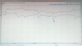
 
pat that is more process than I can retain :) but known that dissolved aluminum is lethal to trout at a concentration of +/ - 200 ug/l. second link in OP gives some data for EBFC tribs, one or two observations per trib, dated 4/27 - 4/28 '09. here are the pH and Dissolved Alum in ascending pH order:

NTrb Mkr: pH 4.2, DA 417
Ore Run_ : pH 4.5, DA 412
Meeker Rn: pH 5.0, DA 290
Pigeon Rn: pH 5.6, DA 200
Big Run__: pH 6.0, DA 153
Quinn Run: pH 6.0, DA 90

streams differ, but looks like a general relation of higher diss alum at lower pH, and usually there would be lower pH at higher flows. so if the acidity ever gets high enough for a pH below 5, the alum would often be a problem for brookies. (also, fish may have safer seeps or tribs as refuge in some cases.)
 
Summary:

Aluminum comes from groundwater, not runoff. You need very acidic water in the ground to release it from the soil, but that doesn't dissolve it. Then you need less acidic water in the ground to dissolve more of it. Hence, the highest concentrations occur from groundwater sources that were once very acidic but are trending towards higher pH's before they emerge.

I don't think aluminum is a problem for brookies or any animals in general. Could be wrong, but I don't think so. It may correlate with something that is harmful, though.

higher diss alum at lower pH

Lower pH forms more soluble Al. Higher pH dissolves more. i.e. levels will be typically higher in low pH streams, but the highest periods may be when those streams are at their highest pH.

and usually there would be lower pH at higher flows.

That's due to runoff. Al should be low during runoff itself. Should be highest just after runoff ends but overall flows are still robust from supercharged springs.

In other words, for streams that get muddy, it'll be highest as soon as the mud clears and you have high and clear.
 
pat the Kirby study on geology and PA brookies mentions dissolved alum, quote from abstract:

Dissolved aluminum concentrations of 0.2 mg/L are "approximately the lethal limit for brook trout"

http://www.ncbi.nlm.nih.gov/pubmed/18258282
 
Back
Top