Heavy Rain

pine looks like this
 

Attachments

  • DSCF2295.JPG
    DSCF2295.JPG
    155.7 KB · Views: 3
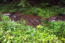
tribs are clear and fishable
 

Attachments

  • DSCF2287.JPG
    DSCF2287.JPG
    247.8 KB · Views: 3
The stream data map looks scary for lots of areas. Some creeks going from 2ft to 18 ft in days!!! 
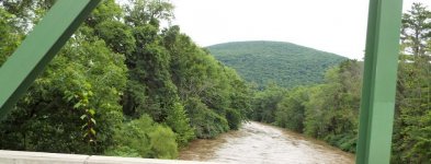
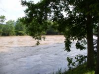
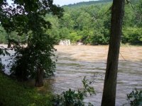
Biblical scale flooding for sure. Stay safe out there people.
and yes, the tribs might be fishing good, but for gods sake, take a minute and think about the thousands of people that are having their lives turned upside down right now, there are people that are just hoping to survive, yet alone worrying about if the fish are biting.
 
Yellow Breeches Anglers Cooperative Nursery was inundated today. Didn’t look good on their Facebook page.
 
Bikerfish wrote;

take a minute and think about the thousands of people that are having their lives turned upside down right now, there are people that are just hoping to survive, yet alone worrying about if the fish are biting.

Amen to that Sir! All of us who aren't in imminent danger of our homes flooding should be very thankful and wondering how we might be able to help those who are, or will be, suffering flood damage.

The attached pictures were taken at my cabin on the WB of the Delaware on June 26, 2006. The water reached around 44,000 cfs. I had 38" of water coursing though the cabin. I can survive 22,500 cfs before getting wet. The flood was twice that. Luckily the structure footers were not damaged and the cabin did not move. That was the good news, The bad news was I had to demo the entire cabin, walls, insulation, hardwood floors, plywood subfloors, all the furniture was discarded or reupholstered. Bought new furniture and had a carpenter install new bead board walls after I installed 2.5" thick hard foam insulation between all the interior and exterior studs. The cost of the demo and subsequent re-build (it took three years) cost me half as much as the initial cost of the cabin.

I just recently deleted most of the flood pictures because just looking at them was very depressing.
 

Attachments

  • Cabin - looking down river (450x338).jpg
    Cabin - looking down river (450x338).jpg
    140.6 KB · Views: 4
  • Cabin - looking upriver (450x338) (2).jpg
    Cabin - looking upriver (450x338) (2).jpg
    150.5 KB · Views: 3
  • Refrigerator door (450x338).jpg
    Refrigerator door (450x338).jpg
    124.5 KB · Views: 3
Things are getting wild in the Poconos. Definitely stopped thinking about fishing. Now I’m just hoping my local bar doesn’t end up off shore of Cape May
 
Hershey made National TV with the flooding. Just bad for those affected. Everyone in the affected area "STAY SAFE"! GG
 
I can’t remember the last time that I saw that many black dots on the the USGS Streamflow map in the Susquehanna drainage. It’s all got to go through the Conowingo dam which is flirting with 300,000 cfs currently. Thoughts and prayers for the safety of the many people that have been impacted by high water conditions across the State and beyond.
 
4 mile brad, straight is good also asaph. not sure in the upper kettle area as I didn't go that far west. the further west the better the water seems
 
Yes, the Hatchery took a big hit. We have lost most of the fish including the larger holdovers and the fingerlings we just received two weeks ago.

Recovering will not be easy.

 
I checked my local brookie stream yesterday morning and it looked perfect. This gave me inspiration to drive back through the mtns on my way back from my drive to York and the three mtn streams I had in mind were all high and muddy. I think we got our worse rain yesterday here in Mifflin County. The Juniata is barely out of it's banks so that is good it didn't get too out of whack and honestly the water here gets this high each spring.

On the bright side the sun is out here and we at least have a little reprieve from the rain.
 
Several of our families in the church are flooded. Western Lancaster got HAMMERED. I'm surrounded by acres of corn fields so we're safe and dry, but just about every road to my house is flooded. Worst flooding since Lee.
 
The Marietta gage is now at 352,000 cfs or 50.6 feet. The site says Moderate Flood at 52 feet and Major Flood at 54 feet. There are many up river streams and rivers that may still continue to raise the Susky levels. The Swatara at Hershey was something like 21,000 cfs and Penns was 6500 cfs and Pine was also very high.
 
Really amazing amount of precip for the central section of PA:

PA Precip Map

Hopefully everyone has remained dry.

Believe it or not, rainfall will continue into next next week. Hopefully not as much, but it really doesn't take a lot of rain to push up the streams and rivers right now.
 
Fishing Creek in Benton was at least 12-14 feet above the normal creek channel. I survived the flooding but the creek almost came out of the bank at my place. I think a lot of home were impacted both upstream and downstream, especially in the low lying areas of the creek

Ron
 
Back
Top