You are using an out of date browser. It may not display this or other websites correctly.
You should upgrade or use an alternative browser.
You should upgrade or use an alternative browser.
M
Mike
Well-known member
- Joined
- Nov 10, 2006
- Messages
- 5,550
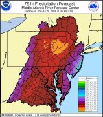
Meanwhile, here at the Fish Mgmt office on Nockamixon Lake in upper Bucks Co, just a few miles from the Delaware and about 13 mi south of Easton, we make daily weather observations for NOAA. Rainfall from Friday until today has only been 1.47 inches.

Beefheart
Member
- Joined
- Jan 20, 2011
- Messages
- 79
krayfish2 wrote:
Swattie is 9' above flood stage !!! Clark's is a solid 150 yards wide at the rt 225 bridge. The fly section has been hurt badly in the past by floods. In my opinion, nail in the coffin
I just started fishing Clark's this year so I don't have a frame of reference for this. What do you mean this flooding is the nail in the coffin?
afishinado
Moderator
Staff member
Dave W wrote:
So far, here in Adams, its mostly been water in basements and overflowing flood plains. Not too serious (yet).
Unfortunately, there is a massive - over a hundred miles in depth - rain line coming up through the mid-Atlantic right now. If this thing continues to track in the direction they have been tracking and doesn't lighten up, it looks like York/Lanc counties and Harrisburg could be in line for a lot of water today and tonight.
Fredrick wrote:
Terrible just terrible . Great time to try lake fishing . Times like these I appreciate my kayak even more
Reading Dave's post above, I believe the concern of most folks is for the families and the property of those living along these streams and rivers.
I don't think anyone is thinking about lake fishin' right now....
One can only hope that the storms are not as intense as feared.
Good luck to all.
Fredrick
Well-known member
afishinado wrote:
Dave W wrote:
So far, here in Adams, its mostly been water in basements and overflowing flood plains. Not too serious (yet).
Unfortunately, there is a massive - over a hundred miles in depth - rain line coming up through the mid-Atlantic right now. If this thing continues to track in the direction they have been tracking and doesn't lighten up, it looks like York/Lanc counties and Harrisburg could be in line for a lot of water today and tonight.
Fredrick wrote:
Terrible just terrible . Great time to try lake fishing . Times like these I appreciate my kayak even more
Reading Dave's post above, I believe the concern of most folks is for the families and the property of those living along these streams and rivers.
I don't think anyone is thinking about lake fishin' right now....
One can only hope that the storms are not as intense as feared.
Good luck to all.
Still would be a nice time for a yak might be the only mode of transportation

Does look bad out there https://www.usatoday.com/videos/weather/2018/07/24/heavy-rains-cause-flooding-woes-central-pennsylvania/37087361/
fritz
Member
- Joined
- Sep 9, 2006
- Messages
- 676
Pine Grove, where I grew up is getting hammered by the Swatara. This is another painful batch of rain for a lot of people.
I was down tending our trout nursery today which is right along Tom’s Run, a trib to Muddy Creek. It’s been high but hasn’t been on the floodplain there.
I was down tending our trout nursery today which is right along Tom’s Run, a trib to Muddy Creek. It’s been high but hasn’t been on the floodplain there.
O
outsider
Active member
- Joined
- May 28, 2010
- Messages
- 1,538
Flooding in Tremont, Schuylkill County:
https://www.youtube.com/watch?v=vuPu7ganHAo
https://www.youtube.com/watch?v=vuPu7ganHAo
C
Canoetripper
Well-known member
- Joined
- Aug 12, 2009
- Messages
- 1,140
I get on/off I-81 at the Ravine exit and could really see that water rising on my home from the Poconos on Sunday. Sorry to see this level of flooding in Pine Grove and Tremont.
Bamboozle
Well-known member
Although it could blow out or at least move some of the huge amounts of dead fall hemlock that has plugged up the middle area of the FFO for years.krayfish2 wrote:
Clark's is a solid 150 yards wide at the rt 225 bridge. The fly section has been hurt badly in the past by floods. In my opinion, nail in the coffin
O
outsider
Active member
- Joined
- May 28, 2010
- Messages
- 1,538
Canoetripper wrote:
I get on/off I-81 at the Ravine exit and could really see that water rising on my home from the Poconos on Sunday. Sorry to see this level of flooding in Pine Grove and Tremont.
I pray for those who will suffer from this rain system. Days ago, tomorrow was predicted as the worst day.
L
lycoflyfisher
Well-known member
- Joined
- Apr 15, 2014
- Messages
- 1,343
Floods can definitely provide function of "cleaning" out a stream, but in unstable watersheds the extreme scouring can really do some damage. I do not have macroinvertebrate samples to back it up, but loyalsock creek for one has been damaged extensively by flooding in the past decade. In reality it is healing itself, but it may be past our lifetime before the improvements are realized. Extreme examples of bedloading such as what has occurred on the Loyalsock can really set back the base of the food chain.
redietz
Well-known member
Gee, maybe I should feel lucky. I'm "only" in the 4-5 inch zone (on top of almost 7 already in the last few days.)
salmonoid
Well-known member
- Joined
- Jun 19, 2007
- Messages
- 2,721
I don't know if it has anything to do with the rain, but I saw the largest blizzard of white flies hatching at Columbia Crossing tonight. A few ventured across the road as I was near Marietta, then turning at the 441 light in Columbia, they intensified. At the railroad crossing, I could see a massive cloud by the river, so I stopped to get some photos and video. It was the largest hatch I've ever seen. Chocolate milk in the river, for sure, but I did see one big riser.
O
outsider
Active member
- Joined
- May 28, 2010
- Messages
- 1,538
I don't know if this system lost some energy, but I've been keeping an eye on the NWS national reflectivity base loop, and the colors are indicating less precipitation coming from the Carolinas. Hope so.
krayfish2
Well-known member
Sal,
Agreed. When I got off the Dauphin exit.... whitefly blizzard at 6:30 pm. Maybe the most I'd ever seen in this area and early in the day too.
Bam,
I hope that's the case but I fear even more bank washed away causing several hundred more trees to topple into the creek.
Outsider,
I saw a clip of the Tremont flooding. I was amazed. In 2010 or 2011, I was detoured off of 81 at Ravine because they feared mudslides near Pine Grove. That area got destroyed. Looked like they had water approaching the 2nd floor in some homes. 3-5" of mud on the streets and National Guard with dump trucks picking up the belongings. Very sad to see.
salmonoid
Well-known member
- Joined
- Jun 19, 2007
- Messages
- 2,721
I volunteered at a job site in White Sulphur Springs, WV this past winter for a week, helping to rebuild a home. The area received 10 inches of rain in 24 hours in 2016. Steep mountains, narrow floodplains (with a town on them), and bridges which were too small to carry that volume of water, plus debris which further clogged up the conduits heightened the misery. Hundreds of homes were destroyed and dozens lost their lives. The flooding in Tremont looks very similar, although thankfully with less loss of life. Unfortunately might not to have to travel out of state to work on rebuilding homes this year :-(
Locally, two young ladies tried to cross Conewago Creek near the Dauphin/Lancaster line Monday night. One of them disappeared and has yet to be found.
Locally, two young ladies tried to cross Conewago Creek near the Dauphin/Lancaster line Monday night. One of them disappeared and has yet to be found.
O
outsider
Active member
- Joined
- May 28, 2010
- Messages
- 1,538
I was a member of the PA ANG based in Middletown when hurricane Agnes hit. Most of the base was under 11' of water. They got the planes out of there, but not the motor pool. What a mess to clean up.
wildtrout2
Well-known member
It's a rare day when you see 3/4 of Pa represented with dark blue/black
dots on the USGS the end of July! I believe once the prolonged high water levels recede somewhat, there's going to be some great fishing on many of the mountain freestones. Get while the getting's good.
dots on the USGS the end of July! I believe once the prolonged high water levels recede somewhat, there's going to be some great fishing on many of the mountain freestones. Get while the getting's good.
Latest posts
-

-
E
-
LDoes anyone know if it’s viable to raise a trout streams PH?
- Latest: lycoflyfisher
-
E
-
D


