Current PA Brook Trout Population as Percentage of Original?

T

troutbert

Well-known member
Joined
Nov 2, 2006
Messages
10,768
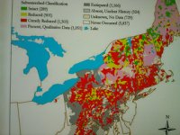
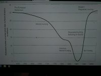
What do you all estimate the current brook trout population in PA is, as a percentage of the original brook trout population, i.e. pre-European settlement?

Of course there is no way to know this exactly, but just what would be your rough estimate? (I will give my own ideas later, after hearing from others.)
 
Interesting question. I guess this can be looked at two ways, as numbers of fish or as poundage of fish. I'm sure they were probably bigger back then because there was less settlement and more foliage hence more food.

I would say numbers, maybe 30% of what it used to be.

Poundage, I would guess maybe less than 10%.
 
Foxgap239 wrote:
Interesting question. I guess this can be looked at two ways, as numbers of fish or as poundage of fish.

Biologists typically use poundage, i.e. weight, i.e. biomass to assess trout populations, and that's probably the best measure, so let's go with that.
 
Come on TB, you know me. I'd have a hard time spelling "biologist". Fortunately you spelled it for me! :)
 
Pre-Euro brook trout population? Gosh, I dunno. I am younger than some of you guys, so I wasn't fishing back then :)

I have read early 20th C fishermen accounts of 20" wild brookies, but not sure what these mean? After all, I know some guys who still catch them! :)

of course if you go back some tens of thousands of years, much of today's brookie habitat was choked with ice and snow-- wait a minute, is it happening again?

Ok I'll stop ... my guess is 30% by # of fish. biomass a bit less.

Not sure what all this means.. much of deforestation etc cant be reversed in reality .. historical range doesnt really tell you about about current viability. black bears greatly reduced from original range included N indiana for example, but that doesn't mean they are doing badly in PA now:

https://www.bear.org/website/bear-pages/black-bear/basic-bear-facts/37-black-bear-range.html
 
ebtjv 'brook trout health map' below. I am not saying that it is wrong, but I saw this when I started fishing and got the impression that wild brookies would be hard to find in PA. very little of PA listed as intact, mostly reduced, greatly reduced, etc ... think it is based on historical range. coded colors may be right based on present versus historical. but I get the feeling there may be good and stable brookie populations in some pa watersheds -- even if they are in fact reduced from some historical peak.
 

Attachments

  • 12970647705_48c031ebcc_n.jpg
    12970647705_48c031ebcc_n.jpg
    72.4 KB · Views: 7
FWIW, I'd add another inquiry to the nature of the question. You could also look at it by % of brook trout holding streams with respectable populations, compared to the original.

By number of streams, I'd estimate we're still at 70 or 80% of the original.

By number of fish, we're probably more like 20% of the original.

And by lbs of fish, probably more like 5%.

Guestimates, of course.

The discrepency is mostly about which streams. The brookies still exist, in often relatively healthy populations, in MOST smallish headwater streams where they always did. But they've been lost or largely lost in the bigger waters. In many cases due to those larger streams being much warmer than they once were, in other cases due to brown trout taking them over.

To clarify, if every little hop across sized headwater stream counts as 1 stream just like Big Pine Creek counts as 1 stream, we really have only lost a small % of the brook trout holding streams.

That said, 1 stream like Big Pine, over 30+ miles, held enough trout to populate several hundred, if not thousand of those little streams, which are much smaller and usually only a few miles in length.

And the average weight of one of those Big Pine fish is probably 5 times as heavy as the average trout from those little streams as well.

Using Big Pine as an example. You could replace it with a number of the largish streams in PA which don't have wild trout, or virtually ANY of the streams which currently hold brown trout and no respectable brookie populations. Streams with primarily brook trout outnumber streams with primarily brown trout over 10 to 1 in this state. But the brown trout streams are generally larger and richer, and more significant to us fishermen.
 
P.S. That post kind of explains why I'm not sure how to take the map that k-bob showed.

i.e. yes, almost all "watersheds" are impaired. The big stream that defines the watershed probably is severely impaired, as well as any larger tribs it may have. But in more forested areas, the little tribs in the system are often in better shape.
 
right so loss of brookies by stream-mile is not so much but by biomass is major. brookies probably fairly stable where they are. bambi came roaring back, but he can live in the burbs:


Attachments

  • 12975149763_d2dda3811f_z.jpg
    12975149763_d2dda3811f_z.jpg
    114.2 KB · Views: 5
Breakdown from the map above:

Percent of watersheds where brook trout were once present that still hold brook trout.
-Green: 1% relatively intact (~90% occupied)
-Yellow: 9% present in reduced percentages (50-90% occupied)
-Red: 39% existing but greatly reduced (
 
Interesting curve. I'd also point out on that curve that modern whitetail populations, where healthy, are actually much larger than pre-European Settlement, at least here in the temperate eastern US.

The reason is that after the logging days, the forests came back with a higher % of hardwoods, which support much larger populations. And also farms, which also support larger populations.

But on a graph like that, those observations have to be combined with the fact that there are not healthy populations in many areas due to development. So more deer in less area = about the same number of deer.

The devil is always in the details.
 
ebtjv map: right only 10% of PA _watersheds_ are that once had brook trout are now 50% or more occupied by brook trout.

do that by PA streams, not entire watersheds, and you'd get a very different picture.
 
Please do not divert this thread to whitetail deer. If you wish to discuss that, please start another thread.
 
deer chart is relevant ... basic issue is that some species do better in changed post deforestation envt than others. also issues of # of animals versus weight of total stock.
 
KenU wrote:
Breakdown from the map above:

Percent of watersheds where brook trout were once present that still hold brook trout.
-Green: 1% relatively intact (~90% occupied)
-Yellow: 9% present in reduced percentages (50-90% occupied)
-Red: 39% existing but greatly reduced (
 
Percent of watersheds where brook trout were once present that still hold brook trout.
-Green: 1% relatively intact (~90% occupied)
-Yellow: 9% present in reduced percentages (50-90% occupied)
-Red: 39% existing but greatly reduced (50% of it's fish, in numbers?

In biomass?

Depending on what you're measuring, it means VERY, VERY different things.

FWIW, I flat out don't believe it means number of streams, because in many of those red areas, >50% of the streams still do hold brook trout. Just doesn't add up.

If by stream miles, maybe. It takes a lot of those little streams, at 1 or 2 miles a pop, to equal the mileage of the larger streams which were indeed lost.

If by number of fish, yeah, I buy it. It takes even more of those little streams, at 1 or 2 miles a pop and a width you can jump across and a couple of fish in each pool a few hundred feet apart, to match the population which was lost in the bigger water.

If by biomass, it's probably an overly optimistic assessment of the situation. I struggle to believe there's any green or yellow in PA!
 
pcray1231 wrote:
Percent of watersheds where brook trout were once present that still hold brook trout.
-Green: 1% relatively intact (~90% occupied)
-Yellow: 9% present in reduced percentages (50-90% occupied)
-Red: 39% existing but greatly reduced (
 
The data are from the EBTJV pamphlet for PA and were generated by the PFBC. The pamphlet says the percentage shown is from subwatersheds. Unfortunately, what constitutes a subwatershed is not described. As I recall from the presentation, subwatersheds are defined by dividing the state into small parcels and then determining whether brook trout lived there at one time and the current status. The number of parcels (subwatersheds) with brook trout populations in the past can then be compared to the present situation. It's not perfect, but does give one a pretty fair idea of the status of brook trout in PA.
 
There are regions there, painted red, where virtually every single small stream holds brook trout. The % of ALL streams currently containing reproducing populations is probably somewhere north of 80%. So it is impossible that brookies were totally extirpated from >50% of streams that used to hold brookies in those regions.

That's my issue. But I tend to think by stream, not by stream miles.

So say you have a medium sized stream, with 30 little tribs, all of which contained brookies. Now the larger stream lost it's brookies cause it's too warm, and maybe 2 of the bigger tribs as well, as they were taken over by brown trout. But 28 still have em, though maybe in somewhat reduced numbers because of acid rain reducing the fertility of said stream. Very common situation.

If you treat it as 31 separate watersheds, now 28 of them still have brookies, and were lost in 3. Far more than 50% still hold fish. If you treat it as 1 watershed, well, it still is "occupied" by brookies in far more than 50% of its member streams. Either way, it shouldn't be red. Which is why in my mind, at face value, the map seems like B.S.

But that 1 bigger stream and it's 2 larger brookie free tribs may indeed constitute >50% of the traditional fish holding mileage, acreage, # of fish, biomass, etc., which would make the map not wrong, but merely lacking a clear enough explanation.

 
if you look at the excellent PowerPoints about unassessed streams also on the conservation forum, I guess the better ones aren't so different in brookies from way back...
 
Back
Top