What vestiges of history have you encountred while fishing?

wbranch wrote:
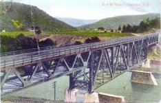
There are remnants of a canal on the walking path side of the Tulpehocken. There used to be a rail line that ran from Scranton, PA to Codosia, NY. It used to cross the WB Delaware just below the Methodist Pool. It was the O&W line and here is a picture of the area from probably over fifty years ago.

All that remains now are the old concrete bridge bases on either side of the river. The abutment picture was taken a few days after the flood of June 2006. The high flow was 45,000 cfs. The structure of my cabin didn't move but 38" of water coursed through the cabin. Luckily at the time I had my drift boat chained to a small trailer. The high water lifted both the drift boat and the trailer it was chained to and took it about 150' down river. Lucky for me the boat and trailer would up on one side of a huge pine tree and the smaller trailer on the other side.

https://www.paflyfish.com/home/paflyfi1/xoops_data/caches/xoops_cache/2548_5fbec088e4704.jpg

An interesting side note about the Tulpehocken canal: it ran through a tunnel that pierced the ridge between the Swatara and Tully creek watersheds.
It's still there, and has been restored into a historic site.
They even give canal boats through it during the summer months.

I also wondered about those abutments on the methodist camp pool.
And finally climbed up that hill to at the sharp road bend to check it out.
And saw that it was an abandoned RR grade.

w branch:
When I fished there last month, some workers were fixing up the cabins at the methodist camp.
I'm guessing that someone finally bought the place.
Do you know what's gonna happen to it?
 
Dryflyguy wrote;

"I'm guessing that someone finally bought the place.
Do you know what's gonna happen to it?"

Actually someone bought that entire property about two years ago. I've never met either the man or the woman but do know they have posted the heck out of the property. There is one tree with two "No Tresspassing" signs on it. One sign faces down river so anyone coming towards their property can't miss it. Another sign on the same tree faces towards the water. I guess in case someone wants to walk on the property. I used to walk on the high water line to get to the riffle above but since it was purchased I've stayed away. A couple friends were in the water, but near the shore, and the lady scolded them and said they couldn't walk there.

I float in with the Hyde and fish there for hours if fish are up. It is a great fish holding pool but it is so deep that waders can't really reach the RR side where the larger fish lie and rise.

I've caught two stripers in the Methodist Pool. Both on Clousers and both on the far side where there is deep water.

Here is another picture of the RR bridge over the WB. You can see from the picture that there is nothing on the far side. No houses or roads at all. My cabin was built about 90 years ago. It is likely this drawing was made prior to 1930. Remnants of the old bridge are still in the river today. If you wade in that area you can see big rectangular chunks of concrete on the bottom. I was told the iron works were dropped into the river, dismantled and carted away. The concrete blocks were too heavy to get out of the river and were left there.
 

Attachments

  • viaduct.jpg
    viaduct.jpg
    11.3 KB · Views: 2
I found the boiler to a locomotive or steam donkey on a remote mountain brookie stream. It's half in the stream at the remnants of a railroad trestle, so I assume it's a locomotive, but I didn't see any wheels or running gear. I'll have to take pics next time I'm there.
 
Some posts just surprisingly take off. This is not one of them! When growing up we would hike Middle Creek Trail. You could find old RR spikes and ties along the trail. It would be so cool to go back and see when the train was there. Wonder what the fishing was like? There are also a couple rock walls along the stream below the trail. I am not really sure if it was there to protect the bank under the trail.
 
I come across lots of stuff with railroad stuff being of the most interest. The stuff that comes quickly to mind:

Old RR trestle footings from the Saucon Iron Company along the Saucon Creek.

Old NW&W trestle abutments across the Delaware near the mouth of the Brodhead Creek

Old trestle near Bangor, PA from the Bangor & Portland RR

Old logging RR crossing and ROW on Clark’s Creek near Victoria Furnace

Remnants of ROW (Reading RR) and old roundhouse near West Branch of Perkiomen near Barto

Former Red Arrow trestle over Darby Creek on Old West Chester Pike in Havertown

Former Red Arrow Ridley Creek trestle abutments and remnants of trolley power station on Ridley Creek

Old reservoirs on Ridley Creek, Mountain Creek, and a few others that shall remain nameless

Old amusement park remnants along Nancy Run in Butztown and another location in Northeast, PA

Old CCC dam breast on Darby Creek in Havertown

German POW names scribed into a bridge over Tom’s Run and Camp Michaux remnants in the Michaux SF

Old beer can pull-tabs on Laurel Run in Perry County

And two full bottles of COLD beer in Pine Creek near Avoca which I drank!! :pint:

However, the coolest thing I ever found is an arrowhead I saw sitting in the gravel along Darby Creek in Havertown after Hurricane Floyd. I grew up in Delco and cut my fishing teeth there, but moved away decades ago.

As a kid I always dreamed of finding an arrowhead but never expected I finally find one a mile or so from where I grew up in the suburbs of Philadelphia while fishing with my nephews.
 
Dang it Bam, I wondered where I lost that old arrowhead.
 
On a hot Summer day, sometimes I’ll leave a can/bottle of beer in the stream to keep cold near where I park my vehicle for when I get back. I found a full, and fresh dated, bottle of Miller High Life on Laurel Run in Perry County in this fashion once. I was tempted to drink it, and I didn’t see anyone else out that day, but I assumed someone left it there for a reason, so I left it alone.

I’ve started deliberately hiding high ABV stouts in the woods in places where I backpack, to “cellar” until the next time I’m there. If anyone finds one of those, you’ve earned it, and can have it. ;-) I’ve often thought it’d be neat to go back to one of those caches, a year or so later, and find a beer there, but not the one I left.
 
I came upon this junk truck this summer.

It seemed to me to be an old ice cream or milk truck - circa late 1940s(?)
 

Attachments

  • trk64.JPG
    trk64.JPG
    128.5 KB · Views: 2
Came across this deep in the wood and thought it may have historical significance for some . . . but after further inspection, I think it's just a wild Swattie spotting.
 

Attachments

  • 20200904_163805.jpg
    20200904_163805.jpg
    281.8 KB · Views: 2
  • cavt5bef2fab9e4a0.png
    cavt5bef2fab9e4a0.png
    39.2 KB · Views: 1
I can see the resemblance, but I think that guy is from another planet. Or, at least the 80’s. ;-)
 
Came across this old stone wall while hiking into Michaux recently.

Probably the remains of some of the old hard scrabble farms that were still up on the ridges after the logging era and that gradually failed and grew over by the Depression era.
 

Attachments

  • Mn86.JPG
    Mn86.JPG
    129.5 KB · Views: 3
Here's a little something from days gone by. :)
 

Attachments

  • IMG_2132 (Custom).JPG
    IMG_2132 (Custom).JPG
    129.5 KB · Views: 4
Dave_W: Those fieldstone walls are everywhere up in NEPA. I'd guess there are 50 of them in Lackawanna SP alone. Sometimes, when I'm daydreaming while walking my dog, I envision the farm fields created by removing these stones and the tremendous labor it took to do so.
 
I've come across quite a few CCC camp markers in my travels. Some sites still have some of the original buildings. To me it's fascinating to imagine how these young men worked to create the infrastructure many of us use today in our recreational pursuits.

Asaph camp - Tioga County
58.jpg
 
Fly-Swatter wrote:
Dave_W: Those fieldstone walls are everywhere up in NEPA. I'd guess there are 50 of them in Lackawanna SP alone. Sometimes, when I'm daydreaming while walking my dog, I envision the farm fields created by removing these stones and the tremendous labor it took to do so.

During my drives to the Delaware river, I've always wondered why there are so many stone walls throughout the countryside along route 191.
Pretty neat to see, though.
Reminds me a lot of Ireland
 
lot of field stone was either property lines or potato fields. after logging potatoes were a big product especially in NE Pa.

 
Oil Creek is an archeological site in and of itself. Most oil stuff you see (in the park) will be from later operactions. It's still old, though.
But it makes me think the sweet smell of raw petroleum accompanies trout fishing.
I was imprinted while young.
 
My favorite is still Michters Distillery.
Americas Oldest right here in Lancaster/Lebanon Counties.

 
Back
Top