using bedrock geology info to fish in acidrain areas

Outstanding article. This past week I've spent so many hours discussing acid rain for the environmental class because it's such a big issue here in PA.

Unfortunately, there's really not much we can do about it, except turn off the factories along the Mississippi Valley.
 
duckfoot wrote:
Outstanding article. This past week I've spent so many hours discussing acid rain for the environmental class because it's such a big issue here in PA.

Unfortunately, there's really not much we can do about it, except turn off the factories along the Mississippi Valley.

About 30% of coal burning power plants in the US still do not have scrubbers.

Getting scrubbers on those plants would help.
 
troutbert wrote:
About 30% of coal burning power plants in the US still do not have scrubbers.
Getting scrubbers on those plants would help.

#@$%^ right. SO2 is the #1 killer.
 
Also, dont forget that the majority of the rock formations are comprised of several different rock types and are sometimes a couple thousand feet thick. It also may depend on what bed or series of beds the groundwater or stream is in. There are many formations especially in western PA (see the Conemaugh group and the Monongahela group) that have everything from highly acidic sandstone, shale, and coal to limestone.
 
PAgeologist wrote:
Look for iron/sulfur deposits leaching out from any outcrops or red/orange/yellow staining of rocks.

Is this what you're referring to? This is at the base of the Rt 80 bridge over Hayes/Black Creek (Carbon). I've seen this not so nice looking stuff on a few wild streams. I think I was told it's not an issue?
 

Attachments

  • IMG_2184 (Custom).JPG
    IMG_2184 (Custom).JPG
    49.1 KB · Views: 4
That looks like some iron/sulfur deposits. It doesn't neccessarily indicate a large problem. A lot of seeps are small compared to the stream they flow into and get buffered out/diluted pretty fast. Some streams may have a small dead zone below the seep until it gets diluted enough.
 
Bob, USGS has wells where they record things like the levels, and other stuff for PA. One of the things they record is PH. I'm not sure how to enter the info they require to bring up the info you want, but I'm sure you can figure it out.
 
It is a cool topic, I've looked at the maps at times and found correlations. i.e. in a given area good streams come out of this formation, and the ones that cross this other formation tend to be bad. I haven't quite gotten to the point of searching new streams based on it, but I should. I still find it really interesting.

As for the glacial till in NY state mentioned on the last page, there is a similar region in NW PA. Upper Brokenstraw drainage, around Corry and in that area. Yeah, it leads to water chemistries very similar to limestone. The streams are good in terms of water chem, and if near a spring, temp too. But the structure isn't the best in that area. Those springs are in nasty, swamp, quicksandy type places.
 
Add me to the list of the interested people.
It was definitely cool to see the correlation between creeks I know to be good, and the geology.
Will definitely use this to help prioritize creeks on my list to check out.
 
I have done several water quality surveys along streams in NW PA. They are a mess to walk along but have great water quality where AMD isnt present.
 
duckfoot wrote:
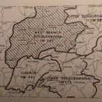
Interesting that Muncy Creek is a Catskill drainage basin.

I would argue that headwater geology matters more important for water pH because the majority of these freestone streams have rain as their primary source. Rain falls onto the long-eroded (via plants and trees) ground and rock, and seeps those acidic qualities into the water.

Bedrock further downstream has much less surface area over a stream's water capacity than does the ground that the rain made first contact.

Groundwater sources (usually come from limestone) are more suited for supporting trout populations.[/quoteMuncy Creek is not in the Catskill Drainage Basin, it's a geologic formation the 2 are very different.
For instance many streams flow off of infertile headwater geology and when they flow down below certain formations, they gain PH, particularly when they flow over the Catskill Formation, which is more fertile. Many NC streams start in less fertile geology and then as they flow through lower elevations cross over the Catskill Formation. Once they flow through the Catskill they become much more fertile as a stream and fishing can be quite good.
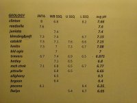
You'll see this in the rocks, many of the streams in the Anthracite regions start on the Plateau where there is pink white and pale gray rock, these streams are very infertile, Northkill is one like this, as well as many of the streams going north from there into Schuylkill County. Northkill has a T Alc of near 0, and is infertile. Even though it is it has a good brookies population throughout. It never crosses the Catskill Formation, but is does cross the limestone valley south of Blue Mountain, and is fed by many limestones spring, large and small and so becomes fertile from around the crossing of I78 south.
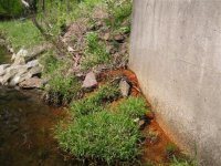
In NC PA streams in the Pine Creek Drainage can have very infertile headwaters, but flow through the Catskill Formation and are eventually very fertile. You can see it in the sediment on the stream bottoms, there is a lot of red rock in the streams indicating fertility.
 
Chaz wrote:
Muncy Creek is not in the Catskill Drainage Basin, it's a geologic formation the 2 are very different.
Thank you, that's what I meant to say.
 
just to clarify, the map linked in the OP can show the bedrock geology of PA.

http://www.gis.dcnr.state.pa.us/maps/index.html

for several parts of the state, four books by taylor have tables of the median chemical analysis of groundwater, including pH, by bedrock:

*Groundwater resources of the Lower Susquehanna River Basin, Pennsylvania / by Taylor, Larry E.

*Groundwater resources of the Upper Susquehanna River Basin, Pennsylvania / by Taylor, Larry E.

*Groundwater resources of the West Branch Susquehanna River Basin, Pennsylvania

*Groundwater resources of the Juniata River basin, Pennsylvania /
Published 1982 Taylor, Larry E


here's a map showing taylor book coverage ... all 4 taylor books can be downloaded via link below (note W54 etc number on image. takes a while). look for table of "median chemical analysis of groundwater":

http://www.dcnr.state.pa.us/topogeo/publications/pgspub/water/index.htm
 

Attachments

  • 14545743823_58ac0ea004_n.jpg
    14545743823_58ac0ea004_n.jpg
    82 KB · Views: 5
below is my "eyeballed across tables" look at some common NC/NEPA bedrock types and relative buffering capacity -- note, this is very quick and dirty, NC/NEPA info is all I looked at, and there are no doubt local/regional differences:

Juniata, Clinton, Lock Haven: VG buffering,
Catskill, Bloomsbug/Mifflintown: G,
Mauch Chunk, Pottsville: G-,
Alleghany, Burgoon, Pocono and Tuscarora: low buffering

so other things (drainage area, access, gradiant, state listings) being equal, I'd rather hike in to an unknown stream starting in Catskill than Tuscarora or Pocono bedrock, for example.

none of this is a substitute for fishing experience, but first you have decide where to go....
 
This topic is fascinating. I have for the past several years scouted stream by looking at topography and trying to match new waters with ones I know are productive. I never considered that topographically similar streams may have different bedrock formations and qualities that could be used to locate an even better match to know productive streams.
 
Jack Some parts of PA have large areas of the same bedrock, so geology wont send you to one stream or another. But in other places, for example just south of Penns, nearby streams start in different bedrocks that are associated with lower or higher buffering capacities.

For example, Swift Run south of Penns has bad acid-rain impact, and it originates in low-bufferin Tuscarora bedrock. Coral Run, a mile or two north of Swift, starts in Reedsville bedrock, which the Taylor tables suggest are higher buffering than Tuscarora. (there is pH info on about 20 bedrocks in the taylor Juniata book, the pH levels range from 6.-8.0, and Reedsville is in there @ 7.6. I have seen Tuscarora cited as low buffering.) Coral Run had some nice brookies for such a tiny little stream the one time I was there. Geology may be worth a look.


Attachments

  • 14523255071_fe93853526_z.jpg
    14523255071_fe93853526_z.jpg
    112.6 KB · Views: 4
Here's a caveat to the entire thing, the streams low in buffering are likely to be all brookies if that's what you're fishing for, and a lightly populated brookies stream is likely to produce some larger brookies, if there is sufficient food base. If brookies are not the only fish in the streams there will be some larger ones, because in infertile streams the brookies prey on fish at an earlier age than in more fertile streams.
A densely populated stream is likely to have mostly fish of 8 inches or under.
If I were looking for a good brookie stream with a good food base I'd look for a stream with a PH between 6.0 and 6.5, because if there are browns in it there won't be many, and the food base will assure growth, making larger brookies posible.
I like the idea of correlating the chemistry of the stream to the bedrock.
 
here's a table of well water ph by region (Juniata, wst brnch susq, Upper Susq, Lwr Susq) from the taylor books ... Clinton or juniata bedrock might be better than Pocono or burgoon...
 

Attachments

  • 14368201860_49a4f69b92_z.jpg
    14368201860_49a4f69b92_z.jpg
    111.1 KB · Views: 4
Here's one I've been pondering.

Over the last 30 years or so, the PH of the rainfall has improved. It's still not good by any stretch of the imagination, but the addition of scrubbers on a fairly high % of coal plants has helped.

Now, we're in the midst of a massive coal plant shutdown, in favor of gas. Many have already shut down, and I think around 30 more in PA and Ohio are planned to close shop in the next couple of years. I would assume the pH of the rain will rise further as a result.

Obviously, this is a good thing for streams. But how much effect it'll have, I'm not sure. As was mentioned, acid rain is a cumulative effect. You progressively use up the buffering capacity. Hence, rather than say it's a good effect, you might say it's "less bad", meaning streams will get worse at a slower rate?

That said, I have trouble believing that higher pH in the rainfall will not raise the pH of any streams. It's got to. And I think I've seen it in some streams in the NW PA. Acid rain affected streams getting a bit better over time, and in many cases, the appearance of browns where there were none or only a few. It's likely especially true during massive runoff events. The most acidic time in a stream is when you have surface runoff, for instance in the early spring when the ground is frozen, and unbuffered rainwater is pouring directly into the stream. Hence, your groundwater sources in freestoners may not be higher in pH, but your low pH spikes associated with these events should be less severe on account of the rainwater being higher in pH. No? And are not these events perhaps the true limiting factor of acid affected streams?

Thoughts?
 
Further, another good question is that IF we were able to improve the acidity of the streams, would it really help the brookie?

I know that there are some very acidic streams with few or no brookies due to acid. And these streams would likely improve, to where they may hold relatively healthy brookie populations.

But alongside those, I think there are some streams with currently stable brookie populations that would switch over to primarily browns. Generally speaking, your brookie populations may merely get pushed even further to the headwaters, while browns take over the lower reaches of what are currently inhabited by brook trout. In some cases, slightly acidic streams could be regarded as the last bastion of brookie habitat, in that it holds off the onslaught of brown trout.

More trout is good, so I'm not suggesting we try to stop this from happening. Just musing out loud.
 
Back
Top