Smike wrote:
Upper gorge is really subjective but generally I think of it as above Mud Run to the dam. The gorge proper is Mud Run down to Jim Thorpe (in terms of geology anyway)
AMD tribs are as follows (from north to south)
Sandy Run
Buck Mt Run (Rockport)
Black Creek (Penn Haven)
Nesquehoning Creek (just above Jim Thorpe) Use to be a major contributor but has had clean up and mitigation added and now supports fish. Buck Mt and Black Creek in the last surveys still do not support trout in them, not sure about Sandy Run.
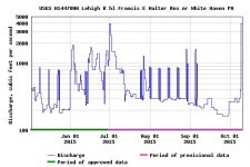
Today overall the AMD is not as much of a major issue as you would think. Two reason, clean up has helped reduce the acidity, (especially on Nesquehoning) and the new flow plan from the dam has helped keep up minimum flows. The flows of these tribs (at least the worst offenders is not all that much compared to the river) the issues are felt more in short term events when the river is low and that reduces the dissipation of the AMD flow into the large stream.
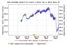
The water temps seem to have greater impact to trout health in the gorge to the dam. In summer the cold pool is lost and water coming out of the dam can reach as high as 75+. Once the water moves downstream the tribs will actually lower overall river temps (plus the depth of the gorge keeps all but the mid-day sun from directly hitting the water.)
Right now the single biggest improvement that can be made is to keep tweaking the annual flow plan from the dam to save as much of the cool pool as possible. There should be an annual meeting with the ACOE in jan and having as many FF show up is extremely valuable to offset the number of White Water boaters asking for more releases.
One interesting fact about the reservoir is that it only takes 6 days to completely cycle the water when its held at 1300’ level, and 60 days when its held at 1368’ level. (i.e. how long does it take inflow to replace all of the water in storage) Since the dam is bottom release this matters at lot to how long it takes to use up the cold pool.