Tropical Storm Ida

Dave_W

Dave_W

Moderator
Staff member
Joined
Jan 24, 2016
Messages
5,098
Location
Gettysburg
So, what are you seeing in your neck of the woods?

I'll have a better picture on this when I get out and about later today. However, my backyard rain gauge showed exactly 5" this morning. This was close to the predicted rainfall for Adams Co. I think weather forecasting is much more accurate these days than just a few years ago.

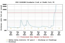
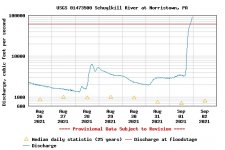
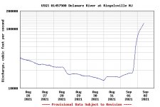
The USGS map shows some worrisome high river levels and many streams are over flood stage, Yellow Breeches, for example. We could see some significant damage to some stream bank habitat, not to mention man-made infrastructure.
 
Around 5” here in the Pittsbugh area. While flooding was severe in many cases, overall it wasn’t catastrophic. Major waters will be unfishable for many days. No smallie fishing for awhile. However, I’m going to fish small brookie streams this
weekend in the Laurel Highlands. I’ll file a report.

One note to add: streams in NW Pa didn’t get hit nearly as bad. Though up, should be fishable. I may head up that way for smallies!
 
I was thinking it would be a great time to hit the brookie streams as well. As we all know, many of them run low and clear most of the time, so all this water will really allow them to let their guard down to some extent.

As far as what I'm seeing, the Conestoga is up, but not near TS Lee levels in 2011 and certainly nowhere close to Agnes levels in '72. Definitely a good soaking rain though!

Screenshot-2021-09-02-at-08-46-59-USGS-Water-Watch-Streamflow-conditions.png


As far as the rest of the state, you can definitely tell where the rain fell!

Screenshot-2021-09-02-at-08-45-28-USGS-Current-Water-Data-for-Pennsylvania.png
 
I saw that the Little J was in flood stage.
My buddies at Greene Hills probably had to move their campers
 
The brookie stream I concentrated on for most of August feeds into a another stream that normally has the 75th percentile at about 217 cfs, it's currently flowing at 4470 cfs. So there's that.
 
Codorus Creek fishes well at 25 cfs, it peaked at 5000. But it will be red by the weekend
 
Southeast PA record floods happening right now on the Schuylkill, Brandywine and lower Delaware Rivers. Gages are out of service in the lower D River so I posted a gage a ways upriver. Really bad stuff!!


Attachments

  • Brandywine River.jpg
    Brandywine River.jpg
    63.3 KB · Views: 4
  • Schuylkill Rvier.jpg
    Schuylkill Rvier.jpg
    62.4 KB · Views: 5
  • Delaware River.jpg
    Delaware River.jpg
    51.5 KB · Views: 4
laszlo wrote:
Codorus Creek fishes well at 25 cfs, it peaked at 5000. But it will be red by the weekend

Ain't that the truth! :-D
 
Got smashed in central PA -- 5 to 6 inches. I think DFG is right that Greene Hills would have had to empty out.
 
For those of you who have been to my place, the river is up to the paved road named "River Road." Th Juniata, that is. We got 5.25" on my rain gauge. It's been this high before and happens every few years.
 
Dumped the rain gauge out around 5 pm yesterday and had 4.5. Another 4.5 from then on.
This is in Carbon.
Took a ride to Cabela's this morning, little skuke was ripping, but falling
 
10"+ of rain in some sections of SEPA.

https://www.iweathernet.com/total-rainfall-map-24-hours-to-72-hours
 
In Philly here, the floods are historical and biblical. Not even lying. Check the pics on some news sites. Waterways will be rearranged for sure, hope the fish could hold on cause I can't imagine how hard the currents must be right now.
 
Yesterday near dusk I took a look at Bald Eagle Creek at Milesburg, a place that frequently gets flooded. The water was high but wasn't flooding.

I followed Spring Creek from its mouth up to Fishermans Paradise.

At some places the water was nearly bankfull. If it was up another foot it would have gone onto the roads.

At Fishermans Paradise it was up onto the grass a little in the lowest areas, but was not up onto the parking lots.

I saw Fishing Creek today. It was high and brown, but I didn't see any flooding.

 
Just under 8" on the USGS gage on the Tobyhanna, which I know that all of you who regularly fish the Lehigh have also observed.

Henri and Ida have dumped approximately 18" combined into the Tobyhanna. That is a lot of rain.

At least in Pennsylvania there is somewhere for the rain to go, like downhill.

In 1982 I lived in New Iberia, Louisiana, which is pool table flat and basically surrounded by swamps and marches, with no place for all of that rain that they got to go except up, and they got hammered first.
 
Anyone have any pics of the Lehigh? I saw it was 25k last night in Lehighton, super curious what that looks like, almost drove up there today just to see it
 
Why is Lehigh outflow less than 200 cfs currently? I'm sure there is a reason but the reservoir is over 1400 now.


Perhaps down river is too high so ACE couldn't add to it with more water from FEW? Waiting for downstream to decrease first?
 
Millsertime wrote:
Why is Lehigh outflow less than 200 cfs currently? I'm sure there is a reason but the reservoir is over 1400 now.


Perhaps down river is too high so ACE couldn't add to it with more water from FEW? Waiting for downstream to decrease first?

What you said is probably correct.

Flood control dams typically spill a lot of water as the storm approaches, to increase storage capacity.

Then when the deluge arrives, they reduce outflow, storing water to reduce flooding downstream.
 
After big floods it is interesting to walk along forested streams to see what changes have occurred.

 
The city of Phila is flooding so they are not adding more water to the problem.
 
Back
Top