steams where you didnt find trout

http://www.epa.gov/airmarkets/progress/ARPCAIR12_02.html#fig_mean_wet_sulfate


ftp://ftp.epa.gov/castnet/tdep/images/s_td/s_td-2000.png

ftp://ftp.epa.gov/castnet/tdep/images/s_td/s_td-2013.png
 
k-bob wrote:
http://www.epa.gov/airmarkets/progress/ARPCAIR12_02.html#fig_mean_wet_sulfate


ftp://ftp.epa.gov/castnet/tdep/images/s_td/s_td-2000.png

ftp://ftp.epa.gov/castnet/tdep/images/s_td/s_td-2013.png
I see 9 stations in PA and NY that the soil hasn't improved it's burning capacity. on the plus side in NEPA the buffering hasn't changes or no longer exceed critical load. There's seem to be a lot of red in NC PA and that's troubling. This is in the 2012 report.
Am I reading it correctly?
 
here's my take, fwiw. link below gives epa's library of total sulfate/acid deposition (sum of acid rain and dry fallout) in map form. large declines since 2000. and as pat points out, there are both regulatory and economic (gas is cheaper than coal) factors leading to even further reductions.

ftp://ftp.epa.gov/castnet/tdep/images/s_td

however, stream water acidity reductions lag behind these acid deposition reductions. soils can retain and release acid, and a lot of acid has fallen in the last 100 years. interestingly, the thinner rockier soils in areas that had glaciers retain less acid than sand-clay soils. so stream water acid reductions, while still gradual, may happen earlier in NEPA than southcentral PA. NEPA had glaciers.

at the level of individual trout streams, there is a wild card. snow retains acid, and can concentrate it, leading to acid shocks with snowmelts. so marginal streams might have more fish when their snowfall had been light in the last few years.

the idea that previous snowfalls matter is suggested by the discussion of these wbtep streams: "Furthermore, it should be noted that during the 2005 through 2011 study period there was very little snow cover during the spring-runoff period, except for 2011. This is an important consideration for these streams and their wild trout populations because young-of-the-year production and fish mortality are greatly influenced by the acidic (snow/rain and organic decay) purge during the initial spring run-off discharge. Thus, the surveys were conducted during a sequence of years when any adverse impacts typically associated with high spring runoff (except for 2011) on production and recruitment were thought to be negligible."

http://fishandboat.com/images/reports/2011bio/5x11_22wild.pdf

I found snowfall data, and at least for scranton, 2013-2014 had a lot of snow....

http://www.weather.gov/bgm/climateAVPAnnualTotals

so any spread of ST to marginal streams might be more likely in the future and after a few less snowy winters...
 
increases in base-rate stream pH after reduced air pollution are very gradual, in this 1987-2003 catskill data, stream pH increased at a rate of .1 pH unit/decade. however, larger pollution reductions happened from 2005-present versus 1980s-2005. still, any effect on ST presence of slow stream pH improvement could be removed when snows are relatively heavy, leading to worse runoff/snowmelt acid pulses.

"Changes in stream chemistry and biology in response to reduced levels of acid deposition during 1987–2003 in the Neversink River Basin, Catskill Mountains"

"Atmospheric acid deposition has decreased in the northeastern United States since the 1970s, resulting in modest increases in pH, acid-neutralizing capacity (ANC), and decreases in inorganic monomeric aluminum (AlIM) concentrations since stream chemistry monitoring began in the 1980s in the acid-sensitive upper Neversink River basin in the Catskill Mountains of New York. Stream pH has increased by 0.01 units/year during 1987–2003 at three sites in the Neversink basin as determined by Seasonal Kendall trend analysis."

good discussion chapter 3 here:

http://www.researchgate.net/publication/233776398_National_Acid_Precipitation_Assessment_Program_Report_to_Congress_2011
 
interesting info if you hit the link below, select a site, then hit the "data" tab, and on the next page select "trend plots." can then select variable such as SO4/sulfate deposition to plot...

http://nadp.sws.uiuc.edu/data/sites/list/?net=NTN

some PA sites such as leading ridge and penn state have data on So4/sulfate deposition back a few decades. large deposition change in the last ten years.
 
I've been following this thread with some interest. I recently had a chance to fish a small North central stream that I've been eyeing for several years now. It's a beautiful piece of water with some decent size for a mountain stream that flows through a state forest. I caught a nice 7" inch brookie on my first cast when I arrived and another one of similar size about 10 or 12 casts later. I thought I was in for a great evening, but I fished another 1.5 hours without a hit. This came as a surprise to me as the structure on the stream got better as I worked upstream, but no more action. Stone turning on the stream revealed lots of caddis houses. More than usual for a mountain stream. So I left the stream perplexed. A little research later at home revealed this is a Class B stream. I couldn't figure out why such a great, medium sized stream with some obvious life didn't fish or rate better. My only conclusion was possible acidification.
 
could be... doesnt sound like s tream with water temp or drying out issues, and the rosenbauer small stream fly fishing book notes that "as you get closer to the source of a steam, acidity increases"
 
Here are charts of rainfall pH and sulfate/acid deposition from the leading ridge PA site PA over 35 years... (using site described in post 65). as pat suggested, large change in last decade. these changes don't directly impact stream water pH, there is a lag based on soils/geology, but they are large shifts still...
 

Attachments

  • 19255875832_910ac8b15a_z.jpg
    19255875832_910ac8b15a_z.jpg
    121.1 KB · Views: 3
  • 19075680309_4240708b38_c.jpg
    19075680309_4240708b38_c.jpg
    144.1 KB · Views: 3
See how the pH suddenly jumps from 4.4 to 4.8 in a span of four years?

That's the equilbrium threshold being reached. What a wonderful thing!
 
Yes, it's a wonderful thing.

It's why I always question the "sky is falling" types. Don't get me wrong, our streams face plenty of challenges, and we shouldn't bury our heads in the ground regarding them.

But the #2 cause of trout problems statewide is verifiably getting better, not worse. And a fair portion of it is due to GAS.

(#1 being de-forestation and the siltation, flow rate and water temp issues it brings. Taken statewide, we're at least treading water on this one, and on public land it could be argued we're improving as the forests mature).

IMO, overall trout fishing is improving in this state, not dying.
 
those changes are mostly driven by durable regulatory and energy cost factors, so they should last. nice thing to see.
 
troutbert: back in post 56 you suggested that streams like ore run that are east branch fishing creek tribs could have AMD along w/ acid deposition. I don't know, never been there, but stumbled into this ore run photo and the rocks may look orange

http://www.panoramio.com/photo_explorer#view=photo&position=8&with_photo_id=65042170&order=date_desc&user=4357360
 
It sure looks like iron staining on the rocks. Very similar to what many AMD streams look like.

Interesting photo, thanks.


Everything you wanted to know about EBFC (skip to the last line for the bottom line):

East Branch Fishing Creek primarily flows in a largely westward direction, from its source at State Game Lands #13, slightly west of Ricketts Glen State Park, to its mouth slightly north of Grassmere Park.[3][4] The creek starts at the confluence of Sullivan Branch and Big Run. It starts flowing southwards for approximately one mile before picking up Heberly Run, its longest tributary. Further on, it receives Lead Run and turns southwest towards Jamison City. Shortly after the turn, the creek receives Trout Run, one of its shortest named tributaries. In Jamison City, the creek receives Blackberry Run and several unnamed tributaries before flowing into West Branch Fishing Creek.[3][2] The total elevation change between East Branch Fishing Creek's source and its mouth is 1,500 feet (460 m).

Hydrology
At one location, East Branch Fishing Creek's discharge is 19.7 cubic feet per second.[3] The average discharges of the streams in the creek's watershed range from 63 gallons per minute at the headwaters of Heberly Run to 15,498 gallons per minute at East Branch Fishing Creek's mouth.

The creek's watershed is acidic. One contributing factor to this may be the presence of acidic bogs. It is a freestone stream.

The average pHs of the streams in the East Branch Fishing Creek watershed range from 4.32 to 5.76. The lowest pH occurs on Meeker Run and the highest pH occurs on Shanty Run. At two sites on East Branch Fishing Creek itself, the creek's pH is 5.34 (at its confluence with Lead Run) and 5.63 (at its mouth). The average amount of aluminum in the streams in the watershed ranges from 0.024 milligrams per liter to 0.366 milligrams per liter. The highest concentration occurs on Ore Run and the lowest concentration occurs on the mouth of East Branch Fishing Creek. One stream in the watershed, Big Run, has a pH range of less than 3 to slightly under 7. The main stem has a pH range of slightly over 4 to slightly over 6.

During a study of the waters of East Branch Fishing Creek and its tributaries, no stream miles in the watershed have been rated as very good. 27% (9.23 stream miles) have been rated as good, 30% (10.21 stream miles) have been rated as fair, 14% (4.8 stream miles) have been rated as poor, 3% (1.07 stream miles) have been rated as very poor, and 26% (8.85 stream miles) have been rated as severe. The lowest-quality water tends to be on Meeker Run, Blackberry Run, Sullivan Branch, Ore Run, and Lead Run. Big Run, Quinn Run, and the East Branch Fishing Creek mouth have the highest-quality waters.

East Branch Fishing Creek receives an average of 39.16 tons of calcium carbonate per year.

The number of pounds of acidity that flow through various streams in the watershed of East Branch Fishing Creek per day ranges from 197.74 pounds (89.69 kg) at the headwaters of Sullivan Branch to 1,788.14 pounds (811.09 kg) downstream of the confluence of East Branch Fishing Creek with Trout Run. The number of pounds of acid per day flowing through East Branch Fishing Creek itself ranges from 1,569.07 pounds (711.72 kg) downstream of East Branch Fishing Creek's confluence with Lead Run to 1,788.14 pounds (811.09 kg) downstream of East Branch Fishing Creek's confluence with Trout Run.

The number of pounds of aluminum that flow through various streams in the watershed of East Branch Fishing Creek per day ranges from 11.73 pounds (5.32 kg) at the headwaters of Heberly Run to 316.35 pounds (143.49 kg) downstream of East Branch Fishing Creek's confluence with Lead Run. The number of pounds of aluminum per day flowing through East Branch Fishing Creek itself ranges from 83.40 pounds (37.83 kg) at the creek's mouth to 316.35 pounds (143.49 kg) on East Branch Fishing Creek downstream of its confluence with Lead Run.

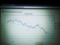
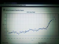
The average water temperature on East Branch Fishing Creek in 2009 ranged from 9.1 °C (48.4 °F) to 11.3 °C (52.3 °F) at various sites along the creek and its tributaries.[4]

Geology
The rock underneath the East Branch Fishing Creek watershed consists of sandstone and interbedded sedimentary rock.[3] However, there is little limestone bedrock in the watershed, unlike many watersheds in Pennsylvania.[2] Most of the watershed is in the High Plateau Section of the Appalachian Plateau Province, but a small part of it is in the Ridge and Valley Province.[4]

There are a number of rock formations in the East Branch Fishing Creek watershed. These are the Burgoon Sandstone, the Huntley Mountain Formation, the Catskill Formation, and the Mauch Chunk Formation. The Burgoon Sandstone primarily occurs in the northern, eastern, and western parts of the watershed. The Huntley Mountain Formation occurs in the southeastern part of the watershed, as well as on most of the main tributaries of the creek. The Catskill Formation largely occurs along the main stem. The Mauch Chunk Formation occurs in a small area in the northern part of the watershed.[2]

There are ten main soil associations in the East Branch Fishing Creek watershed. These include the Dystrochrepts/Deep-Wellsboro-Oquaga, the Oquaga, the Lackawanna, the Lackawana-Oquaga, the Wellsboro, the Barbour, the Morris, the Norwich, the Udifluvents, and the Basher. There are also rock outcroppings and several minor soil associations. The soils in the watershed are all strongly acidic, except on East Branch Fishing Creek itself.[2]

The Dystrochrepts/Deep-Wellsboro-Oquaga soil association occurs in close proximity to East Branch Fishing Creek and its tributaries themselves. The Oquaga soil association occurs in the Blackberry Run, Trout Run, Lead Run, Heberly Run, and Piegon Run sub-watersheds. It also occurs in the northwestern corner of the watershed. The Lackawanna soil association occurs in the southern part of the watershed, starting just below Blackberry Run's confluence with East Branch Fishing Creek. The Wellsboro soil association occurs near the headwaters of Blackberry Run, Lead Run, Big Run, and Heberly Run. The Barbour soil association occurs on East Branch Fishing Creek near its mouth. The Morris soil association occurs in scattered areas in the northern part of the watershed. The Norwich soil association occurs in some areas at the headwaters of Heberly Run, Lead Run, Piegon Run, and Blackberry Run. The Udifluvents soil association occurs near the confluence of Heberly Run and East Branch Fishing Creek. The Basher soil association occurs in the southeastern portion of the watershed.[2]

Watershed
The watershed of East Branch Fishing Creek is entirely within the boundaries of Sullivan and Columbia Counties.[2] There are a total of 34.16 stream miles in the watershed. As of 2010, there are 100 people in the watershed. 93.03% of the watershed consists of forest, 6.86% of the watershed is grassland, 0.06% of the land is agricultural, and 0.03% is water or wetlands. None of the watershed is barren.[3] The entire watershed has an area of 19.5 square miles.[2]

History
One of the first settlers in the vicinity of East Branch Fishing Creek was Thomas Fritz, who arrived there in 1795 from Philadelphia.[5] In 1864, a group of Union Army troops searched for deserters and draft evaders in East Branch Fishing Creek. This event is known as the Fishing Creek Confederacy.[6]

In 1907, the community of Jamison City was supplied with fish and fish eggs from East Branch Fishing Creek.[7]

United States president Theodore Roosevelt had a 700-acre mountain resort near to the creek.[8]

Fauna and flora[edit]
23.8 of the stream miles in East Branch Fishing Creek's watershed are a high-quality cold-water fishery.[3] However, due to the low pH of the tributary Heberly Run, there are not many fish there.[4]

 
From the Sullivan County Chesapeake Bay Tributary Strategy Report, page 5:

The following Sullivan County streams are listed on the 2004 Pennsylvania Integrated
Water Quality Monitoring and Assessment Report (formerly the 303d list).

West Branch of Fishing Creek (5C)- Total miles of impaired streams = 40.62

Atmosheric Deposition (Total miles = 40.62)

Atmosheric Deposition/Metals
- East Branch Fishing Creek (and unt) - 4.64 mi.
- Ore Run (and unt)- 1.11 mi.
- Heberly Run (and unt)- 5.72 mi.
- Sullivan Branch (and unt)- 5.06 mi.
- Meeker Run (and unt)- 1.19 mi.
- Hunts Run- 0.49 mi.
- Pigeon Run- 1.30 mi.
- Long Run (and unt)- 4.25 mi.
- Big Run (and unt)- 2.52 mi.
- Lead Run (and unt)- 1.84 mi.
- Blackberry Run (and unt)- 2.91 mi.
- Hog Run- 2.02 mi.
- Trout Run (and unt)- 1.88 mi.
- Elk Run (and unt)- 0.43 mi.
- Peterman Run- 1.63 mi.
 
OK, but I caught a few ST in heberly at twin falls 'bout 4? years ago. None at big falls if I remember correctly. And even a few in sullivan run. I believe others have done the same. back when the winters weren't as bad...

The long east branch fishin' creek report linked post 42 shows approx 5.7 pH for heberly quinn and shanty in 2007. The rainfall pH is probably up a bit, and acid depo is down, since then. But we've had a lot of snow last two winters, and the spring acid pulses may be the biggest issues for such streams.

If our winters stop being crazy, I'll go back to quinn and shanty sometime (hopefully the one w/o swampy headwaters). I was there bout on that trip four ? years ago, saw no ST but it's a truly beautiful place...

 
Back
Top