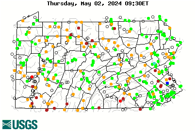
Serious rain coming to most of PA

krayfish2 wrote:
Pretty much a swing-and-a-miss by the weatherman in the Harrisburg area

Pretty much a strikeout in Middletown (work) and home as well. Some stream gauges show water levels hitting the median... And falling already. Kettle Creek was up to a whopping 20cfs! Bit of a fizzle (so far, I reserve the right to change my prediction if it rains a lot, even though I am not a weatherman..).
 
Well coming out of the northeast it looks like rain but only a few drops so far. Let it rain let it rain let it rainnn.
 
NC had maybe 1/2 inch, streams are still to low and dry as of 3:22 pm
 
I'm guessing that if 1.5" fell, very little will make it to the creeks. Ground is soaking up majority of it since the rainfall rate is so slow. Still a good thing though
 
1.5-2" down around York, big cries are muddy but not up much.
 
We much have gotten a bunch over night. All the streams are high and muddy.
 
It has been a steady mist / drizzle in the Susky valley. Looks like it dumped from Philly up through Lehigh Valley late yesterday. Other places seemingly got snubbed. Strange system. Still sitting there, still spinning and now looks to be sucking more moisture in off the ocean so ..... it over til it's over.
 
And when it's over, Matthew might put a big explanation point on it. One can hope....

Comon Matt. Screw Jersey. Come on in!!!!
 
Unfortunately, it looks like most models predict Mathew will make a right turn at the Outer Banks.

https://www.wunderground.com/hurricane/atlantic/2016/Hurricane-Matthew?map=ensmodel

 
krayfish2 wrote:
It has been a steady mist / drizzle in the Susky valley. Looks like it dumped from Philly up through Lehigh Valley late yesterday. Other places seemingly got snubbed. Strange system. Still sitting there, still spinning and now looks to be sucking more moisture in off the ocean so ..... it over til it's over.

Was it over when the Germans bombed Pearl Harbor......hell no!
 
Unfortunately, it looks like most models predict Mathew will make a right turn at the Outer Banks.

Despite the multiple lines, your link is 1 run of 1 model. It's the GFS ensembles. Same model run over and over with slightly varied initial conditions to get a feel for how sensitive the outcome is to small adjustments in the setup. If all the ensemble paths are on top of each other, then that model gives the same result even if the data you got a piece of bad data in the mix. It's not very sensitive. If the paths are spread out, it says that something like a single ocean buoy going haywire might alter the model's prediction by a huge amount.

But it's still 1 model. All of the ensembles are run on the same equations. Different models do show different things. Here's a couple.

https://www.wunderground.com/hurricane/atlantic/2016/Hurricane-Matthew?map=model

The red line is the GFS that you posted, main operational version. I'll take yellow. Comon yellow!!! Blue might work out ok too.
 
It might rain a lot.

Or not.


I'm thinking or not! We didn't get enough! Stinks
 
More importantly the lake temp has dropped to 68 today. Gotta have fish trying to get in the tribs before you need flows to get them in and up. 68 widely viewed as the trigger, right or wrong.
 
They have been out there south wind more important IMHO stream flow will track out further into lake. More rain coming in a few hours.
 
Well done sir, well done!
 
Rained a good amount on the west side and the NE areas of PA. Wish central PA got more rain. Pictures of Erie I've seen -,creeks got rain but look like they will quickly be low again.
 
They could get 20 inches and they'd quickly be low again, lol.
 
Back
Top