albatross
Well-known member
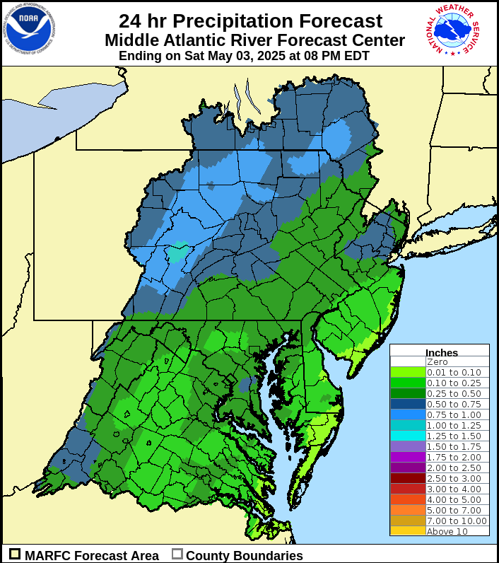
Another rain event coming to usher in the weekend. Maybe a half inch more in State College for example by Saturday.
Enough already!
Enough already!
troutbert wrote:
When forest roads are in the floodplain:
https://www.youtube.com/watch?v=qjrpV_A8eH0
Big Bear Creek, Lycoming County
Without another whopper, they could all be in really nice shape for sulphurs.
troutbert wrote:
troutbert wrote:
When forest roads are in the floodplain:
https://www.youtube.com/watch?v=qjrpV_A8eH0
Big Bear Creek, Lycoming County
Has anyone driven up the road along Big Bear Creek (Loyalsock drainage) since the flood of 2011.
I'm curious what they did up there regarding the road and the stream.
When I drove up there sometime before the flood, I noticed that the road was actually at a lower elevation than the stream channel.
That's not a good thing!
tomitrout wrote:
Until I see this gage get back into the realm of 'normal' flows, keep on bringing these soakers, one a week all summer long would be great. Our local groundwater levels are still scary low.
https://waterdata.usgs.gov/pa/nwis/uv?site_no=01569460

Swattie87 wrote:
Thus far, today's radar is less impressive than I thought it would be given the predictions, especially the further north you go. WUnderground dropped their prediction through Sunday for State College (I've been using that as a center point for the Jam) back down from 1.25 inches this morning to 0.85 currently...about where it was yesterday.
lycoflyfisher wrote:
troutbert wrote:
troutbert wrote:
When forest roads are in the floodplain:
https://www.youtube.com/watch?v=qjrpV_A8eH0
Big Bear Creek, Lycoming County
Has anyone driven up the road along Big Bear Creek (Loyalsock drainage) since the flood of 2011.
I'm curious what they did up there regarding the road and the stream.
When I drove up there sometime before the flood, I noticed that the road was actually at a lower elevation than the stream channel.
That's not a good thing!
Some sections of the road were raised, but as a whole there are still sections of the road that are right along the stream and still definitely in the floodplain. Major rain events are still going to raise havoc. The stream appears to be developing nicely, several stretches have habitat and bank stabilization structures. Some sections are still wide and flat trapezoidal channels especially closer to the lower end.
Swattie87 wrote:
Assuming no rain as forecasted, by next weekend I think Spring will be perfect. LJR pretty darn close to perfect too, maybe just a touch high, but very good. Penns, a little high, but fishable. If this holds, we hit the lotto IMO.
mr7183 wrote:
Swattie87 wrote:
Assuming no rain as forecasted, by next weekend I think Spring will be perfect. LJR pretty darn close to perfect too, maybe just a touch high, but very good. Penns, a little high, but fishable. If this holds, we hit the lotto IMO.
Penns will be perfect IMO. I was in the island section of the C&R yesterday and it was still wadable in the longer flats. By this weekend, it should be flowing around 500 with that Penns green color. I'm jealous because I think you guys hit the jackpot.
I ran into two guys floating Penns yesterday (first time I've seen that). FWIW, they said the fishing was fantastic from the boat two days ago.


