A Cumberland Valley Loss (Cedar Run)

LetortAngler

LetortAngler

Member
Joined
Sep 6, 2013
Messages
607
Location
SWPA
Sad to say I came across a report and pictures today claiming the complete "loss and devastation" of Cumberland Valleys Cedar Run. The pictures I saw were of a completely dry stream-bed around the Camp Hill section. Have never fished Cedar due to it being mostly privatized and developed, but nevertheless, if true, a very sad ending to such a storied Limestone stream.
 
The following is a copy of my original Facebook post with an edit in the middle:

"Cedar Run - a little gem of a limestone stream" - Vincent C. Marinaro

With great sadness, I am reporting the total devastation of Cedar Run in Lower Allen township (Camp Hill) PA. Amidst the left and right political rumblings of the last election season, nobody has seemed to notice this once praised stream slip away. Spring creeks are somewhat dependent on rain but entirely at the mercy of the local aquifer for their very existence. This creek had water last month - I'm 90% sure the local quarry operations played a larger part in this travesty than a drought. Less than 10 miles away, the same thing is happening to Hogestown Run (another one time trout stream) as evidenced by extremely reduced sediment laden flow. THAT'S TWO OF SEVEN FOR THE CUMBERLAND VALLEY WORLD FAMOUS SPRING CREEKS DESTROYED! I had caught wild Brown trout from HTR within the last two years and Wild Browns from the pictured stretch within the last five years. Our local chapter of Trout Unlimited has either not been informed or has given up. (To clarify: I'm not blaming my local Chapter 052 - just wasn't sure if they were aware of this. I'm not sure what kind of resources can fix this. They are apparently advised on this issue and I will be taking a more active role in my membership). Please share if you care!These creeks are vital to our area in terms of drinking water AND tourism and they are literally flowing down the drain into nearby quarry pits as the aquifer is (probably) irreparably damaged. Tears of anger in Mechanicsburg this day

C95E1F9F-D13E-4C88-AFD6-8C1CD8C68162.png


Location of photos - the large "lake" on the lower right margin is the quarry pit where I presume the water from the stream has gone

D768E9BE-31C9-4841-8C91-0F44D86657C2.jpg


Looking "downstream" of the Lisburn Road bridge.

C4080104-FD60-42ED-B6CF-80579A0ED8E0.jpg


"Upstream" view looking toward retirement center - vicinity of old Cedar Run Elementary School (also gone)


Yikes. Nothing upstream or downstream at all either? This definitely needs looked into. Hope you guys can figure something out over there.
 
CVTU is aware of the issues with Cedar and we've been in touch with DEP and Fish & Boat about it. We've also been contacted by the Yellow Breeches Watershed Association. Apparently two new sinkholes have opened up, one on the prison property and another near the confluence of the two branches. DEP will happily issue the permits for repair work on the sinkholes, however we been told that since the sinkholes are on private property, there's not much, if anything, we can do to compel the landowners to repair an in stream hole.

It's truly an unfortunate event and a sign of the times. All of our local spring creeks appear to be running at record low flows currently and with our underlying karst geology and dropping water table, it seems like it's not a matter of if another sinkhole will open, but when. We are diligently keeping an eye on the waters we can work with, but as Cedar and also Hogestown are mostly all on private land, there's only so much we can do.
 
I am so sorry to read this. When Marinaro and Fox wrote of Cedar Run and its sulphurs, the stream must have been truly amazing. I hope something can be done to restore Cedar Run.

The local little limestoners are mere trickles this fall, too. Increasing demands on them and the local aquifer will probably eventually destroy them, too. I hope I do not live to see it.
 
I'm surprised Trindle hasn't been completely swallowed up yet. Luckily there isn't much room for further development on the lower end.
 
All of our local spring creeks appear to be running at record low flow

I'm worried that the Donegal is suffering the same fate... it's not dry, but the levels have been terribly low and seem to only be getting lower.
 
The Donegal is nowhere near the stream it was only twenty yrs ago. Overall a much smaller, shallower and more silted waterway than anytime in past. Since you brought up Lancaster County...Swarr Run and Brubaker Run (both limestone creeks and tributaries of Little Conestoga) are also at about half of what they were twenty yrs ago. Loads of development and destruction of wetlands in the headwater sections of some of these streams. Lancaster has quite a few Limestone creeks but they are so destroyed you would never know it. So sad about Cedar. Was recently reading Fox's book about Cumberland Valley streams and he mentioned it.
 
This is sickening. Are all these stream deaths and decay due to urban sprawl and "development" on this aquifer? Have there been any steps, studies or actions taken to get to the bottom and try to put a stop to it, or correct it? Is it even possible? Sounds like it will be a matter of time before the Letort, Falling Spring and Green Spring suffer the same fate. WTF!
 
All sad and true - every well from every new home puts additional strain on the aquifer, existing homes are having to drill deeper to draw water too. The drought isn't helping either. I may move to Wisconsin after retirement after all to fish the rest of my life in the Driftless region.
 
Even if they're on city water, I imagine the blasting from preparing to build on the land is a contributor. Ive watched Trindle along Mulberry & Woods drive go from always having water, to disappearing. Luckily most of it still manages to meet and comes back above ground further down.
 
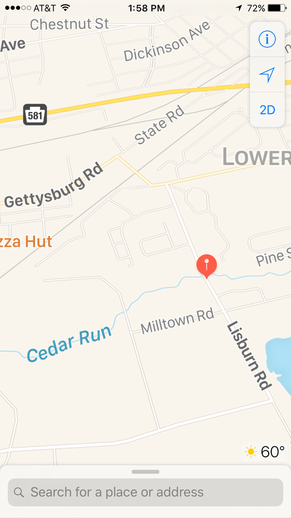
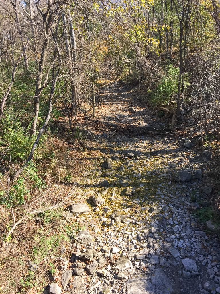
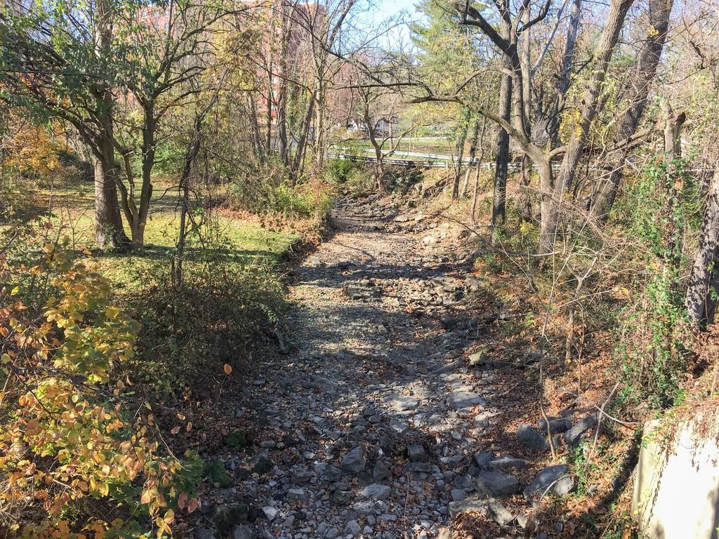
When you are talking about aquifers, water movement in a karst region is entirely different than in a non-carbonate bedrock region. In a karst region, water tends to move in conduits through the limestone (almost like pipes, where the carbonate weathers out). These conduits often dissolve along original bedding planes or fracture structures. In non-carbonate bedrock, water in an aquifer moves either along fractures, or slowly through pore space in the rock.

Development in a karst region can: draw the overall water table down, and rearrange the piping (so to speak), which either diverts, reduces, or in rare cases vastly increases the local surface flows.

Quarry operations, as they mine downward, or laterally, may intersect the underground piping and divert flow that was originally into a stream eventually into the bottom of the quarry. This often gets pumped out, but if it is returned to the stream well below where it originally entered, whatever in between can dry up. Blasting can loosen up the clay in clogged conduits and divert flow within the general area of the blast as well.
 
Several different streams have been mentioned here.

And two different causes of low flows have been mentioned:

1) Quarry pumping problems.

2) Land development (impervious surfaces reducing groundwater recharge)

The land development problem is probably affecting all of them.

But which streams have the quarry pumping problem, and which do not?
 
troutbert wrote:
But which streams have the quarry pumping problem, and which do not?

Can't speak in regard to the CV, but the Upper Tully in Lebanon Co. has this issue. The surface flow doesn't disappear (or hasn't yet), but it's definitely reduced. The quarry has mitigated this to a degree and pumps the water back into the stream downstream.

Cedar Hollow Run (Valley Creek trib) runs into, and then out of a large quarry just south of the Rt. 29 slip ramp on the Turnpike.

 
Pretty much all those mentioned are impacted by quarries: Cedar, Hogestown, Trindle Spring and the Letort all have quarry operations in close proximity with various accommodations to pump water back into the streams from the pit. There are also some quarry operations out around Big Spring and Green Spring, but not as close in proximity and development hasn't taken quite the toll out there yet. I've heard Cumberland County is the "fastest growing" in the state, not sure by what metric though.
 
I haven't had time to look at Cedar since this thread was started? Is there still water above the prison property, behind the commercial properties?
 
I hope so. There were nice fish over there
 
There is water in the north branch from Camp Hill borough. The sinkhole is downstream of the prison property close to where the north branch(es) join. Stretch around the tire shop/BJ's seems to have decent flow. I have not checked headwaters around Allen Jr High. The headwaters flow at the old Farm on the south side of Slate Hill Road is also Bone dry. There are 4 new townhouse complexes (with more planned) in the immediate vicinity. Farewell my beautiful valley! It appears we've learned nothing from our Lancaster county neighbors in terms of farmland and resources conservation. My home of 53 years has become victim to urban sprawl. Not kidding about Wisconsin -
 
So much pressure on these fragile little waterways that beckon our fishing call. As mentioned previously, I'm surprised Trindle hasn't completely dried up as well. The pressure on these creeks from water usage and development is tremendous. Overall development in a watershed can really impact water levels in a stream as it doesn't allow sufficient recharging. The Donegal watershed gets hit with a one-two punch as it pertains to these issues. Not only has development created more impervious surfaces, but the water authority also pulls municipal water from one of the stream's sources. In the short number of years I've been fishing the Donegal, water levels have continued to decline. This is a sad post regarding Cedar because I think we're going to be seeing more stories like this in the future. These fragile works of nature can only withstand so much pressure before eventually caving at the hand of mankind.
 
Nice to see PennLive caught the story thanks to JG63.

https://www.google.com/amp/www.pennlive.com/articles/19695044/camp_hill_creek_disappears_to.amp
 
Back
Top