That Snowpack!

What this MIGHT be doing it pushing off the early hatch dates so there aren't any April 1st Hendricksons. While it's GREAT to fish to fish rising to mayflies as soon after winter as possible, the early hatches seem to stretch-out the period and thin the density of bugs. With low water temps and higher, discolored water and a 6 month (or whatever) pause in legitimately good surface bug activity, I want some bug density to get the fish looking up.
Grannoms are different. Too much of a good thing. Nothing un-fun about swinging and tight-lining grannom wets and feeling that hard take, but really, REALLY, don't you want to see risers?

The other possibility is that everything melts two weeks from now and we have highs in the mid 60's the first week of March and little rain.

Guess which scenario I would not bet against....

For the record, I think that this year will be closer to what we consider normal, but there's a reason we have a forum thread that is lampooning that very speculation.
 
Glad 'y'al are gettin' it! We've had a lot of snow down here, one of the winteriest winters I've seen since living here. Snow and ice almost every week in 2025 so far. We got a snow blade for our John Deere this year, and it's been a great year for that investment, that's for sure!

Snowpack will surely help the chit-ridden coal country streams.

Snowpack LOL
 
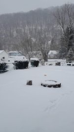
From our most recent round (Sunday afternoon into evening): The ground had JUST melted off a good portion of the prior snow, which was about 8", followed 3 days later by another 5" plus freezing rain. Had a bit of a warmup heading into the weekend and it was finally able to melt off...just in time to get busted again w/ another 5-6".
 

Attachments

  • WhatsApp Image 2025-01-19 at 12.32.38.jpeg
    WhatsApp Image 2025-01-19 at 12.32.38.jpeg
    109.8 KB · Views: 16
The map doesn't show that. It shows no glacial deposits in Mifflin County.

The rock filled mountain slopes in the ridge-and-valley area aren't glacial deposits.

This short video explains how those were formed.

I believe there were additional glacial advances not indicated on the map. Glacial periods go back from the Late Pleistocene Epoch and longer. Not sure what kind of advances the older 200,000 year old glaciers made.

So looking into the Hickory Run boulder field they bring up the same actions of spheroidal weathering on the bedrock. Basically this process is when bedrock gets exposed after long periods of extreme weathering as described in the video. I thought the Hickory Run boulder field was a moraine from a till, but it's not. It is the same as Loysburg Gap, but with many glacial cycles over running the area for 750,000+ years on that spot.


Ice_ages2-3490606301.gif

from
 
You can check out the NOAA snow analysis page to get the 'water equivalent' map. My rule of thumb is 7" of snow= 1 inch of water equivalent. Thing is, the snow melts everywhere slowly, usually, soaking in better. But if 7" of snow = 1 inch of rain, that is just a normal 1 week+ of normal spring/summer precipitation, 3-4 months away from when it is relevant. The current map shows in the range of 1 inch of water equiv. in Happy Valley.
Snow is typically a 10-12:1 snow/water ratio. If it gets really cold, that may go up to 20:1. 7" is closer to 0.5" of.liquid.

We do not have snowpack in PA. Which is why the west has snowpack monitors and we don't. We get snowfall. It melts but never does all of that seep into the ground. A good bit evaporates. A good bit runs off when it melts. Having a few feet of snow that melts over a few weeks is certainly better than a flash melt in a day but it is not a major source of groundwater recharge in PA.

Snowpack is the close to 1000" of.snow that fell in the Alta, UT area in the mid 90's. I had geology field camp there in July of 96 and the year before, they had to modify some of the exercises, due to snow in the heights. Even when we get our rare 2 feet of snow here, that's just plain old snowfall. Not pack. 2" of rain max, like a heavy summer thunderstorm.
 
I believe there were additional glacial advances not indicated on the map. Glacial periods go back from the Late Pleistocene Epoch and longer. Not sure what kind of advances the older 200,000 year old glaciers made.

So looking into the Hickory Run boulder field they bring up the same actions of spheroidal weathering on the bedrock. Basically this process is when bedrock gets exposed after long periods of extreme weathering as described in the video. I thought the Hickory Run boulder field was a moraine from a till, but it's not. It is the same as Loysburg Gap, but with many glacial cycles over running the area for 750,000+ years on that spot.


View attachment 1641239656
from
The map includes "pre-Illinoisian" glaciation, greater than 770,000 years.
 
The other possibility is that everything melts two weeks from now and we have highs in the mid 60's the first week of March and little rain.

Guess which scenario I would not bet against....

For the record, I think that this year will be closer to what we consider normal, but there's a reason we have a forum thread that is lampooning that very speculation.
I'm rooting for the first paragraph. Now that I'm old, I don't enjoy this single digital stuff.
 
Top