Susquehanna River - Access Denied, York County

JakesLeakyWaders

JakesLeakyWaders

Active member
Joined
Oct 25, 2008
Messages
1,545
Location
York County Pa
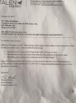
Just going to put this here, a letter with a Mike K__________ addressed has been floating around on facebook this past week. The letter states of closure to access of several key areas of and near the Susquehanna River between York Haven and Saginaw. I came on here to see if there was a buzz about this and so I haven't seen or heard a peep, I think since my community is buzzing a bit I'd like to see if anyone on here has heard about or knows any details about this. As far as I've seen this goes into affect November 1st 2017.

I sent a message to Mike on here hoping maybe he would know something. The message is below, it's a bit informal and I apologize for that.


"So whats the scoop on the Brunner Island Access being completely shut down, including the launch below the dam, the warm waters and the wetland area. There's going to be a lot, of pissed off people. I take my dog to the wetlands and the boat launch. Just wondering if there is any talk or information. I thought the launch was a state owned right of way area. Pretty sad deal considering the launch is a mile upriver from the plant. Lots of people go there to fish, watch eagles, launch boats etc. It is also the only legitimate place on the entire York County side from below the York Haven Dam down to Accomac or Wrightsville to launch a boat, Gut road is often too low or rocky. That's basically an entire stretch of free flowing river from the outflow of the York Haven Power Plant down to the Lake Clark basin with absolutely no decent access for anything larger than a canoe most seasons."
 
I’ve heard this same thing. Don’t know it it’s a rumor or something that is in the works. I was just out there Friday and everything was open. The boat launch/access on the north end near York Haven is, as far as I know owned by the Brunner Island power company. Unless that changed.

Access that is closed til I believe December 1 is the catwalk at the York Haven hydro. The hydro plant spillgate is open which blocks access to the catwalk. Sign on the gate says something like “catwalk closed from September 30 to December 1 to allow juvenile fish passage”.
 
After responding to JLW's PM, I then saw his post here. I know nothing about this and I don't follow or participate in Facebook, so JLW's PM was the first time that I had heard about any closures, real, threatened, or rumored.
 
JLW - can you post the letter? I'd be interested in seeing it as I access that area and work quite close to it.

As for future access areas.... PM sent.
 
I have never had problems posting images on this site it will not allow me to post an image of this letter in any form, shape or size on this site.

The letter was addressed to a Mike Kauffman, another Mike I believe from a local Sportsmans club or such.
 
here is the letter
 

Attachments

  • talon letter.jpg
    talon letter.jpg
    141.9 KB · Views: 31
Yeah that's the letter.

This literally closes all access to any boating from York Haven to Wrightsville to people on the York County side. Since there are no bridges from Harrisburg to Wrightsville this means accessing this area from Lancaster would be quite a long drive for anyone in this community who has spent decades on the river which was, prior to this, only minutes away. Most people don't know about this yet, news is going to spread quick when the signs go up, and people are going to be furious.

This section of river is blocked from boat navigation by the York Haven Dam to the North (upriver) and rapids and shallow water to the south, so this access point is very important for access from York County. What happens when the the fire company has to a river rescue and is confronted with a gate and has to deal with security to access the launch.

I had a conversation with a woman at Brunner Island who was a gaurd. They recently limited evening use of the warm water area. I was stopped and questioned and asked for my drivers license. The conversation I had with this woman left me offended. She said she didnt understand why people come here to fish, then stated that when she wants to fish she just goes down to the harbor. She made several off handed remarks and was obviously not from this area and knew little about the river. I remained polite but was really pissed off by her comments and lack of common knowledge and professionalism. So we are down to this, dealing with people that know little about conservation or fishing nor have any respect for the sport dictating to us about our sport and where we can practice it. So obviously the answer is I should go down to Baltimore and fish in their sewage.

Unfortunately, this is the attitude, our freedoms are being limited for the sake of security and liability reasons.
 
This new company SUCKS BIG TIME! They have zero respect for those of us who have used these areas for generations. They came in and immediately put up ugly fencing and signage and shut down areas. They would be wise to keep a friendly relationship with locals.

Norfolk Southern and these kklkl all seem to think they own the river.
 
Brother anglers,

Preservation of public access to the Susquehanna at Brunner Island may be possible.

There is a strong likelihood that a landing site at Brunner's Island is endowed with the legal trappings of a riparian public access.

In English please: That is to say, it may have once been essentially a public landing / public harbor on the Susquehanna. The York County land records website shows what appears to be a road bed (looks like modern Board Road) crossing the power company territory. It bears a striking similarity to the roadbed shown on an 1876 map that can be seen at:

http://www.yorkblog.com/universal/2015/04/23/more-on-eibs-landing/

Moreover, the power company territory is identified in historical documents as Eib's Landing, then Day's Landing, then New Holland, then Saginaw. As a practical matter, a component of this territory is that in the 1870s it would have been a hub of the lumber trade on the Susquehanna River.

For those of us seeking a place to launch a boat and do a little fishing, the situation is that if the road end shown on the historic map of Eib's Landing was a river access used by the general public (as would be indicated by it being the end of what appears to be a public road), then it constitutes a public landing.

Once a territory becomes a public property, it is unusual for that public ownership status to lapse. First, the public (that is to say, the state), does not have to pay taxes on the property, so it cannot be lost that way. Also, adverse possession (squatters rights) are extremely difficult to establish against a government (otherwise people would be setting up squatter camps on public lands all over the place and ending up with free hunting and fishing camps, among other things).

In addition, the Susquehanna is considered one of Pennsylvania's "Great Rivers," which means the riverbed and water are owned by people of the Commonwealth.

If it can be established that a public landing / river harbor existed where Board Road (or just that a landing existed) once ended at the Susquehanna River, members of the public at large have a very legitimate claim on river access at Brunner's Island.

A group of determined citizens, with the help of a civic-minded lawyer can gain the upper hand in situations where a claim can be established. If nothing else, a large corporation can be persuaded to make territorial concessions in return for certainty when it comes to ownership rights.

Unfortunately, it is likely to take a hard-nosed approach. As Foxtrapper mentioned, there are many big corporations that seem to believe they, not the Commonwealth, are owners of the river.


Sad that we may very well need to get lawyers involved in what was once so simple. PP-&L was a MUCH more community minded. friendly company back in the day. This new faceless corporation has already made many enemies. I'm sure they don't care a bit.

They've also been lowering and raising water levels like I've never seen in 40 years. BAD for river! (I would think some of this would be of concern to our PAFBC but apparently not.)

I have been in court twice without any representation (imagine that!) against Norfolk Southern for denying river access. I won once. Actually the judge threw the case out. Second time a PA Fish Comm employee lied and said I was blocking a roadway on Norfolk Southern property. (VERY sad to realize whose side the fish warden was on.) I received a trespassing citation on that one.

At any rate these corporations often assume ownership without knowing even where their actual property lines are. And certainly they will not respect navigable waterway laws etc. UNLESS they are enforced.
 
I don’t know who you are referring to for raising/lowering river levels but far as I know neither Talen or PPL owns any hydro plants nowadays. Agree with you on Talen. PP&L was way more community oriented. Talen is an energy company pretty heavily invested in coal plants. Word on the street has it that the closure stems from a cutback in Brunner Island’s rented security force to patrol the perimiter. Don’t know if this is coming from Talen or the Brunner Island Plant management. At any rate, it would be a huge loss of access enjoyed by many.
 
I think Brookfield owns Safe Harbor. Same crappy deal as all the rest of these companys
 
foxtrapper1972 wrote:
I think Brookfield owns Safe Harbor. Same crappy deal as all the rest of these companys

Brookfield owns Safe Harbor and Holtwood. Talen owns Brunner Island. I know a guy who works for Talen - definitely a different beast than PPL. Recent drawdowns of the Safe Harbor pool are (I believe) related to the installation of a new sewer line from Columbia to the LASA facility south of Washington Boro, specifically for the water crossing of Staman's Run, which is impacted by pool level fluctuations.

Money won out over birders a few years ago, allowing Brookfield to keep the water levels higher in the Conejohela Flats, and ultimately generate more electricity.

There is tremendous pressure on the power producers currently, with natural gas putting on a lot of that pressure. The person I know who works at Talen tells me that the companies that survive the current low prices for power will eventually emerge stronger and do well in a better market. But they have to survive to do that. In this cry for public access, it is often lost that companies have to cut costs at time to remain viable. I'd hope that all parties consider all of the facts before starting a social media storm (but who am I fooling with that wish?). Note that I don't support losing public access simply due to corporate greed, but I'm also sympathetic to economic pressures that all companies face, and that sometimes, they need to make cuts to help the bottom line.

And for all of those against power companies, I guess that means you will stop posting on here, since presumably you will stop using electricity that they produce. Or is it easier to rail against corporations that produce something that you ultimately consume, but not alter your lifestyle to cut that consumption out of your life?
 
Safe Harbor (Lake Clark) has has max and min pool levels established in their operational plan for years . The min levels differ on weekends and weekdays. Generally speaking, since I do not know any specifics in this case, if the levels are lower than normal, Salmonid's explanation regarding a special temporary variance sounds reasonable. Timing may have been established to avoid the spring spawning period as well as the peak summer recreational period, both of which are often considered in permitting processes.
 
Mike- I hear you about levels but I notice constant up and down. The lower Conestoga will be running backwards several times a day. The river levels are likely now tied to computers telling when they should be generating and when they should cut back....based on profits. (Just a guess). Just like in every other matter just follow the money!

As far a access goes...How in the world can anyone defend Brookfield or the railroad or other power companies. They've sold off land once open to public and shut down others. They are making a ton of $ so not buying the cost excuse.. They took most of the land in the first place using eminent domain tactics and with an agreement to allow public access from what I've heard.

It's never enough with these companies.
 
Looks like it's official - http://lancasteronline.com/insider/brunner-island-closes-popular-fishing-spot-to-public-conestoga-river/article_864a5c8a-bf36-11e7-8fde-7b2e22912ca7.html
 
Well, another good reason to get that kayak I’ve been looking at. Can access that area with it. Hopefully something can be worked out going forward.
 
They'll be able to hide fish kills a bit easier now.
 
"They'll be able to hide fish kills a bit easier now."

-------------------------------------------------------------------

True. They certainly have not helped the environment. What a terrible company. What a shame that they have any control of anything especially our river.
 
JimKennedy wrote:
Brother anglers,

Preservation of public access to the Susquehanna at Brunner Island may be possible.

There is a strong likelihood that a landing site at Brunner's Island is endowed with the legal trappings of a riparian public access.

In English please: That is to say, it may have once been essentially a public landing / public harbor on the Susquehanna. The York County land records website shows what appears to be a road bed (looks like modern Board Road) crossing the power company territory. It bears a striking similarity to the roadbed shown on an 1876 map that can be seen at:

http://www.yorkblog.com/universal/2015/04/23/more-on-eibs-landing/

Moreover, the power company territory is identified in historical documents as Eib's Landing, then Day's Landing, then New Holland, then Saginaw. As a practical matter, a component of this territory is that in the 1870s it would have been a hub of the lumber trade on the Susquehanna River.

For those of us seeking a place to launch a boat and do a little fishing, the situation is that if the road end shown on the historic map of Eib's Landing was a river access used by the general public (as would be indicated by it being the end of what appears to be a public road), then it constitutes a public landing.

Once a territory becomes a public property, it is unusual for that public ownership status to lapse. First, the public (that is to say, the state), does not have to pay taxes on the property, so it cannot be lost that way. Also, adverse possession (squatters rights) are extremely difficult to establish against a government (otherwise people would be setting up squatter camps on public lands all over the place and ending up with free hunting and fishing camps, among other things).

In addition, the Susquehanna is considered one of Pennsylvania's "Great Rivers," which means the riverbed and water are owned by people of the Commonwealth.

If it can be established that a public landing / river harbor existed where Board Road (or just that a landing existed) once ended at the Susquehanna River, members of the public at large have a very legitimate claim on river access at Brunner's Island.

A group of determined citizens, with the help of a civic-minded lawyer can gain the upper hand in situations where a claim can be established. If nothing else, a large corporation can be persuaded to make territorial concessions in return for certainty when it comes to ownership rights.

Unfortunately, it is likely to take a hard-nosed approach. As Foxtrapper mentioned, there are many big corporations that seem to believe they, not the Commonwealth, are owners of the river.

Apparently I am missing something.

Sure the waterway is public domain, but just because an access and a road appears on early maps doesn't mean squat (pun intended).

Back in the day, many of the roads were privately owned, and if the state never bought it, it isn't public.

Furthermore, if it was at one time public, it doesn't mean that it didn't revert to private ownership at some point. This has happened many times, especially in dead-ends like that.

My brother lives on a private road that I am sure would appear on old maps. Was used for lumber and oil.

I can show you many roads in PA and Ohio, some of which were public at one time.

I can show you public roads on old maps that don't even exist anymore, and the land is now privately owned.

If the Government doesn't need a road anymore, and doesn't want to maintain it. At one time it wouldn't be unusual for said Government entity to deed it over to the surround landowner(s). This was at least true back in the day.

I don't know the area, and am playing devils advocate to some extent (for educational purposes). And I am not saying this isn't worth looking into. It is. All I am saying is that you may be making false assumptions. Since we are talking about dry land, whether it was public at one time is not extremely relevant IMO. I think one would need to research the deeds to determine who actually owns it.
 
Back
Top