Public creek "private" due to a club

Having obtained many special permits to run fishing tournaments on the Delaware river I can assure you the permits do not grant the tournament exclusive fishing rights to the fish in the waterway during the event or leading up to the event. The permit simply alerts the PFBC to the activity that they may wish to monitor. It also requires a catch and mortality report be filed at the completion of the event.

You need to know that if you’re told to leave private property and you refuse you are guilty of a misdemeanor 3 crime. Granted that’s only a max of 90 days in the slammer and a $5000.00 fine but I’m still not risking arrest by arguing something I know nothing about other than what I learned on the internet from others equally as ignorant on the law as I. It would be cheaper to buy your own trout and throw them in a creek so you can catch them. that’s not my kind of fishing no matter who bought the fish. I’m sure the club thinks there’s a good chance you and your friends are going to this section because you heard about big store bought fish stocked by the club. if this kind of fishing was my thing, I would join the club instead of looking for an angle to argue and risk arrest.

I'm with Bamboozle, if you like stream access stop arguing maritime laws with landowners. My property is my property, nobody else’s. If there is a trout stream running through it, having a fishing license does not make it your property and I do not lose my right to deny access. It’s really that simple.
It wasn’t the land owners who were even involved, it was one of the club guys. I would understand if I was keeping the fish, but I’m letting them all go. Said club member made no mention of trespassing, just told me to leave and come back after Memorial Day. This is French creek in Chester county, lower stretches of it.
 
I recommend getting OnX or a similar GPS app if you can justify it. Especially useful if you hunt and hike too. It shows you every single property boundary in the state very clearly, and if you're in the backcountry without service you can have the map predownloaded and still know what land you're on. I've never had to guess if I'm on public, or private land as long as I have used the app. I'm not associated with OnX, I've just found their app useful!

I imagine TroutRoutes is similar to OnX and I would imagine be more useful for fishing but I've never looked into it.
 
Just remember onx or any other web based service that provides parcel info is never 100% accurate. Many times property lines are close, but I know places where they are off by hundreds of yards.
 
Just remember onx or any other web based service that provides parcel info is never 100% accurate. Many times property lines are close, but I know places where they are off by hundreds of yards
I was wondering if TroutRoutes/web Apps were accurate or not. Is there one that is better than the rest?
 
I was wondering if TroutRoutes/web Apps were accurate or not. Is there one that is better than the rest?
They all use the same govt. GIS data. Virtually all of the info available through these apps is available for free elsewhere. For instance, your county has a website that will have an interactive map that will show you property parcels and ownership info. It's all free, you just have to dig. This is the data that apps like onx uses. They just make it easier to access all the data in one app and viewable on one map. The apps are mostly selling convenience and they throw in some gimmicky tidbits. For instance Trout Routes has their own classification system for how "good" streams are.

There are some inaccuracies and inconsistencies in the mapping, but it is pretty good. For what it's worth those inaccuracies are generally due to poor data or poor data entry on the govt.'s side. The only other limitation is the precision of your phone GPS.
 
I propose a Pop-up PAFF Jam on this creek. All in favor?
 
I propose a Pop-up PAFF Jam on this creek. All in favor?
I don't think the landowner would grant everyone access, but if you're up for a couple-mile hike in, then go ahead. There's trout in every riffle and slow stretch that seem eager to eat. Might be a mess if two anglers hook two fish at the same time, they run you into backing right away.
 
I recommend getting OnX or a similar GPS app if you can justify it. Especially useful if you hunt and hike too. It shows you every single property boundary in the state very clearly, and if you're in the backcountry without service you can have the map predownloaded and still know what land you're on. I've never had to guess if I'm on public, or private land as long as I have used the app. I'm not associated with OnX, I've just found their app useful!

I imagine TroutRoutes is similar to OnX and I would imagine be more useful for fishing but I've never looked into it.
If I’m in the backcountry and don’t see any posted signs or purple paint while hunting, hiking, or fishing I’ll continue in blissful ignorance rather than constantly check-in on my smartphone or GPS enabled device. Chances are if it ain’t well marked nobody’s gonna be out there to bust my balls about it. That burden lies firmly on the landowner not the person who accidentally crosses from State Forest onto private land.
 
I don't think the landowner would grant everyone access, but if you're up for a couple-mile hike in, then go ahead. There's trout in every riffle and slow stretch that seem eager to eat. Might be a mess if two anglers hook two fish at the same time, they run you into backing right away.
Bring a few flycrafts and float down into it! It’s navigable after all. Bonus points if you completely blow up the spot all the club people are fishing in the process.
 
If I’m in the backcountry and don’t see any posted signs or purple paint while hunting, hiking, or fishing I’ll continue in blissful ignorance rather than constantly check-in on my smartphone or GPS enabled device. Chances are if it ain’t well marked nobody’s gonna bust my balls about it. That burden lies firmly on the landowner not the person who accidentally crosses from State Forest onto private land.
I agree, and that's usually how I operate as well. I guess I more so meant that it's useful in times where you need to check land boundaries but don't have service. There a lot of instances where I'll check out new streams, and be right near civilization in a hub of private land boundaries with cell service that is either spotty or non existent. With a downloaded map, I can still get an idea of what's what. But yeah in true backcountry the only time I'm popping up OnX is if I want to mark a waypoint for something cool that I'd like to come back to.
 
I don't think French Creek has been determined by court to be navigable so if a landowner owns both sides they could restrict access. Stream access laws in PA are complex and I would proceed with caution in most cases. If you access from private property and have permission from the actual property owner you would be fine.
A specific water in PA is either public or it private. Whichever is an existing fact. Courts do not declare a water public or private -- courts merely affirm the existing fact.
 
A specific water in PA is either public or it private. Whichever is an existing fact. Courts do not declare a water public or private -- courts merely affirm the existing fact.
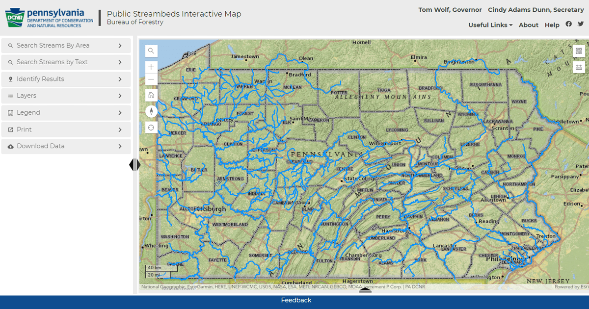
^ True. Linked below is a map of PA "public" waters. BUT, if an individual is accused of trespassing on/in a "public" stream or river, one must prove said stream or river is indeed navigable and is in fact water open to the public. "At your own peril" as they say. After the major rivers of PA, very few smaller streams have been "proven" to be navigable. Recent court cases for proven public waters are the Little Juniata and the Lehigh River.

 
Last edited:
^ True. Linked below is a map of PA "public" waters. BUT, if an individual is accused of trespassing on/in a "public" stream or river, one must prove said stream or river is indeed navigable and is in fact water open to the public. "At your own peril" as they say. After the major rivers of PA, very few smaller streams have been "proven" to be navigable. Recent court cases for proven public waters are the Little Juniata and the Lehigh River.

Went to site. So the ones marked in blue are legally public stream beds? Meaning, I assume that I can freely wade them without the surrounding landowners permission? Otherwise what would be the point of this map? Why would I then need to go to court if challenged? This is nonsense. (Some of these marked streams are tiny trickles by the way).
 
Went to site. So the ones marked in blue are legally public stream beds? Meaning, I assume that I can freely wade them without the surrounding landowners permission? Otherwise what would be the point of this map? Why would I then need to go to court if challenged? This is nonsense. (Some of these marked streams are tiny trickles by the way).
From the website:

"NOTE: The waterways identified herein as having publicly-owned streambeds have been compiled by the Commonwealth over time from various sources. Identification is based upon information believed to be reliable and persuasive evidence of such ownership. The identification of a waterway as having a publicly-owned streambed herein is not intended to be a final determination that the waterway is navigable under state or federal law."

What that means for French Creek is that no one (including PFBC, DCNR, state police) knows if it is navigable or not. And no one will know until if and when it is tested in court.
 
Last edited:
I'm aware of the derby situation and let them do their thing when they are having a contest regardless of the legality. Once got told I couldn't fish two different stretches there on the same day; two different contests. Shrugged and went elsewhere and caught lots of trout. Came back a week later and landed a 6lb Rainbow on one heavily fished stretch. As I get older, large dumb stockers have way less appeal. Have wanted to fish French this year but as it is ridiculously low I don't find it compelling. Maybe because I remember "the good old days" when I learned to fly fish there in the eighties and you could buy flies and tackle from the local hardware store. Just this geezers two cents...


^ True. Linked below is a map of PA "public" waters. BUT, if an individual is accused of trespassing on/in a "public" stream or river, one must prove said stream or river is indeed navigable and is in fact water open to the public. "At your own peril" as they say. After the major rivers of PA, very few smaller streams have been "proven" to be navigable. Recent court cases for proven public waters are the Little Juniata and the Lehigh River.

When the Little Juniata case was in the courts PFBC and DCNR entered the case as amicus parties. The state combed through historical news records looking for any proof of commercial use on the Little J. While combing the news archives the state researchers cataloged every proof they found for any other river. After the evidence the state found for the Little J was determined in court to be legally sufficient the state published a list of any other river for which the state found equivalent proofs. Given the legal proof was sufficient for the Little J case it is reasonable to expect the cataloged legal proofs are sufficient for any other river on the list.
 
Something I never understood about this and please know I'm a property owner and a private property advocate.
So before anyone gets all violent with comments to my question, know I generally side with property owners.

But why is it one must prove a waterway to be navigable to be free from trespassing charges?

In any other charge of crime, the burden of proof is on the state to prove you broke a law, not for you to prove you didn't.

So when charged with trespassing, shouldn't it be up to the state to prove it isn't navigable?
 
If navigable, the waterway is considered public. Otw the landowner owns to the middle of the waterway.

As a landowner and ‘public property advocate’ - while I may not like or agree with all of the laws (or navigability classifications), I understand navigabiliy and the public’s right to access, as well as the private landowners rights. As I’ve heard before, knowledge is power. If it’s navigable and you enter the waterway legally, you can go all over the place to the high water mark (and kudos to you for doing it legally)… once you vary from this, you’re a trespassing jerk.

“Public waterways” are just that, for the public and need to be respected as such. Similar considerations for private property (which navigable waterways to the high water make are not, they are public) need to be given as well.
 
Something I never understood about this and please know I'm a property owner and a private property advocate.
So before anyone gets all violent with comments to my question, know I generally side with property owners.

But why is it one must prove a waterway to be navigable to be free from trespassing charges?

In any other charge of crime, the burden of proof is on the state to prove you broke a law, not for you to prove you didn't.

So when charged with trespassing, shouldn't it be up to the state to prove it isn't navigable?

Because in PA, excluding the major rivers, navigability in fact typically trumps everything else.

Common sense & logic should make all but the delusional realize some of these ridiculous smaller streams with barely enough water to clear a spring log jam are not and SHOULD NOT be considered navigable...

Those who want to push that point will ultimately lose while further reducing access through landowner courtesy...
 
Back
Top