partially channelized stream

k-bob

k-bob

Well-known member
Joined
Jul 29, 2009
Messages
2,371
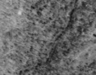
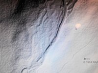
image is a detailed land contour model of painter run above its input to watres reservoir (this < 10 mi SE of Scranton)...

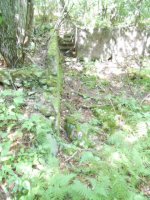
at one point, the stream abruptly changes from a normal chaotic stream bed to a channel that looks almost like a road. I have fished this stream in the channeled-looking section, found it a bit wide and shallow, but I would not have known it had been channeled.

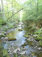
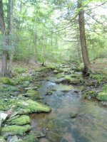
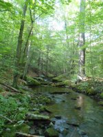
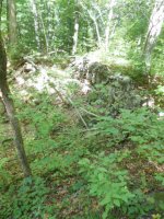
as Dwight points out, many streams were probably channeled to move logs or whatever, and it probably wasn't good for trout.
 

Attachments

  • DSCN0815.JPG
    DSCN0815.JPG
    123.2 KB · Views: 17
There see tons of streams like this- BFC, many in SWPA. Yes, not good.
 
if you select "preview" on the link below, then toggle the gray contour map on and off by checking/unchecking the "3.2 ft digital elevation model" box at upper right, zoom in to painter creek and follow, seems pretty clear.

http://www.pasda.psu.edu/uci/DataSummary.aspx?dataset=1247

area feels remote now, RR abandoned, etc. history of logging as in much of the state I assume.
 
Bob,

Thanks for the image. It sure looks like it's been straightened.

How long do you think this straightened section is?

And could you describe the location of the straightened section a little more?

I looked on the topo map on AcmeMapper, but I'm not sure of the location.

I found Watres Reservoir. Nearby I found Painter Creek tributary to Panther Creek, which flows into the stream below the reservoir.
 
Troutbert, for location, try...

-75.63429. 41.27828

Can't get more specific than that.

If you can't go to coordinates, pull up the stream you were looking at and then move the mouse around until you get close to that.

But the map has no key, so I can't tell you the length without looking it up on another map.

I tried entering those numbers on Google maps and it put me in Antarctica.

Switched the signs and it put me in Greenland.

Oh wait. Switched the numbers and it put me right there. Looks to be about 150 meters, give or take 50 or so. Google maps doesn't have the detail to be sure.

What can I say, it's my lunch time.
 
Gets confusing, there is a stream and a trib. On some maps the stream is labeled Panther (w Painter as the trib), and on others the stream is labeled Painter (w Panther as the trib). the stream is channeled of course, not the steep small trib.

on the usgs topo map, the stream is labeled Painter and the channeling begins at 1440ft on the stream. from there down it looks channeled.

or if you open google maps, and paste "41.27828, -75.63429" in to the search box, that's about the start of the channeling. maybe there are channel cats :)


Thanks Bob. Very interesting.
 
odd that I have fished that stretch w/o noticing the channeling.. it is brushy in the summer I just thought it was a bit featureless
 
there is about 1.5 mi of channeled stream length above the outlet from the watres reservoir...

from the nice hiking blog Redraw the Map, here is a higher-flow image of the Painter-Panther confluence.

https://redrawthemap.files.wordpress.com/2014/06/14515766794_18151cabb4_k-e1403900516699.jpg

laser contour shows that it was channeled here, but doesn't really look that bad?
 
IDK, it doesn’t look that much different then it did in 1939. Some of the same trees. Hat tip to somebody on this site, I got this image from http://www.pennpilot.psu.edu and zoomed in on the same ~300 yard box.


Attachments

  • Panther_run_05.16.39.jpg
    Panther_run_05.16.39.jpg
    84.2 KB · Views: 5
If the channeling was done as part of logging it might be more than a hundred years old. But it looks quite crisp, at least in some stretches, in the original post lidar image ... that image taken w/in last ten years
 
I walked painter creek/run to the point where apparent channelizing ends (appox. 1440 ft on stream, see post 3). Some boulders across stream there, here is 1 picture looking downstream to channeled section from the boulders... then another shot from boulders looking upstream at apparently non channelized section....

the stream section above apparent channelizing is narrower, has big trees on banks, less straight, fished better...

see also picture 3, a short distance above end of apparent channelizing... channelized section doesn't look this good...


Attachments

  • Below.JPG
    Below.JPG
    137 KB · Views: 8
  • Above.JPG
    Above.JPG
    136.6 KB · Views: 8
  • BitAbove.JPG
    BitAbove.JPG
    137 KB · Views: 10
In all of these photos the channel appears to be against the hillslope on the "river right" side of the valley (right side looking downstream).

Is there a flat floodplain extending from the stream channel to the hillslope on the opposite side (river left)?

If so, about how wide is it?

Did you see any structures, such as rock walls, or old road or rr grades in the floodplain?


not sure about floodplain river left... but there are wall/cellar? remains near stream on "river right" at almost the end of the channeled section... logging road or logging RR remains also

Second fuzzy picture is a rock wall


Area has been added to pinchot state forest I believe.
 

Attachments

  • wll.JPG
    wll.JPG
    137 KB · Views: 7
  • cll.JPG
    cll.JPG
    137 KB · Views: 5
I didnt take many pictures but one clear difference in the channeled/ not channeled stretches: as I walked up, the area above the channeling had more big trees close to the stream channel. their roots were often undercut by the stream, making nice looking fish habitat. (as you can see in picture labeled "Below" in post 12, the channeled area didn't have much in the way of big trees right on the edge of the stream)
 
amazing how clear stream channeling is in the lidar maps linked in post 3 (click "preview")... for example, just north of the Watres reservoir is the Nesbitt reservoir. it has two tribs on its east; green run and rattlesnake creek.

the channeling of rattlesnake creek looks very clear in lidar
 
K-bob: I have never been to Painter Run, so my comments are in the realm of guesswork. Both the Lidar and the Google Earth images indicate a rather broad floodplain at the location of the channelized reach. As Troutbert points out, the channelization has fixed the stream against the right descending valley wall. Usually this sort of channelization occurs in order to protect some sort of infrastructure, and the Google image shows a roadway running upstream from the reservoir. After Hurricane Agnes in 1972, quite a large number of stream reaches were channelized using federal disaster relief money.
 
I have spoken to some old timers from NEPA who told me that an awful lot of locals went out and purchased heavy equipment after the Agnes floods of 1972, in anticipation of the federal dollars. Most of these people were put to work clearing debris from streets and roads, but many were also employed to clear the stream channels to make them safe for floodwaters. At the time, the thinking was that a canal was better at moving floodwaters than a sinuous channel. There's some engineering truth to that idea, except for the maintenance costs. Also, we have learned that channelization simplifies the lotic ecosystem, thereby reducing species diversity, including trout.
 
The channelization of Painter Run might have been one of the Agnes boondoggles intended to help the locals cash in on the federal money. Send Reuben up Painter creek to clear the channel. Or perhaps there was an old woods road running up the valley that the locals wished to maintain. In both the lidar and google images, there is clearly a parafluvial channel over against the left descending valley wall. It is quite possible that the Agnes storm filled the right descending (active) channel with debris, causing the stream to avulse into the parfluvial channel on the left side of the valley, over near the road. In such a case, it would be natural to "send Reuben up there to put that stream back where it belongs."
 
interesting tups I don't know how old the channeling of painter is, but the stream doesn't look that bad to fish it. from lidar image you imagine a canal :)

also, nearby rattlesnake creek is channeled above and below a 12-15' waterfall, don't know if that might seem inconsistent w/ old channeling to move logs?

 
Back
Top