wildtrout2
Well-known member
With Kettle over 600cfs, is it safe to say it's from snow melt? The whole region is up pretty good. NC has been getting robbed when it comes to rain in recent years.
wildtrout2 wrote:
With Kettle over 600cfs, is it safe to say it's from snow melt? The whole region is up pretty good. NC has been getting robbed when it comes to rain in recent years.
drakeking412 wrote:
thats awesome to hear and a really good sign going into spring
lycoflyfisher wrote:
While our snowmelt ill not feed streams all spring, I think the duration of snow cover and the fact that we didn't have a deep frost has to be good for groundwater recharge.
k-bob wrote:
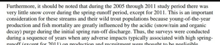
Snow melts can produce unusually high acid levels in streams, affecting trout populations. I like these kits to see pH out there fishin.

k-bob wrote:
TB upper kettle: "sites on the mainstem of Kettle Creek seem to
have normal pH levels except for streams with
AMD problems in the lower watershed" p 165.
http://www.kettlecreek.org/uploads/2/5/6/0/25607137/5waterquality_compa.pdf
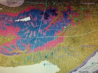
p 205 shows bedrock geology of upper kettle, it's huntley and catskill, generally higher buffering.