Mountain Streams Near SGL 111/Laurel Hill Creek Tributaries

silfeid

silfeid

New member
Joined
Apr 6, 2017
Messages
26
Hi All,

I'm trying to find information about some streams located on or near State Game Lands 111 in Somerset County, and the ol' Google isn't of much help, so I thought I'd try posting here.

One of my last posts was about the area between the mouth of Cranberry Glade Run and Whipkey Run on Laurel Hill Creek, and after hiking into the area, I can say that it's absolutely beautiful down in there, although the illegal ATV riders were a bit annoying. As far as the fishing on Laurel Hill Creek goes, we'll give it another try this season with the stockies, but fishing in August and early September, all we caught were some bluegill and rock bass - fun, but not the quarry we'd been seeking. My suspicion is that Laurel Hill Creek just gets too warm by July to allow more than a bare handful of trout to hold over. Really wish the dam at the lake could be converted to feed from the bottom instead of the top...

The streams that feed into Laurel Hill Creek down that way are really stunning though - classic Laurel Highlands freestone mountain streams. We didn't get a chance to fish them, but I've been doing some wintertime hiking scouting them out, and researching online as well. Although the scenery is great and most of them have a fair number of plunge pools, I've yet to eyeball a trout, which might not mean much. The internet would seem to indicate that water quality is good and that they hold trout, but there's not a lot of evidence to go on.

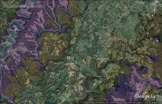
What I'm wondering is if anyone on the forum has fished any of these streams for natives? Specifically I am talking about Sandy Run (above and below the bridge on Sandy Run Road), Cranberry Glade Run, Harbaugh Run, Flugey Hollow Run, Whipkey Run, and Green King Run. I have found some stuff indicating that a few of these hold fish, but the info is dated and very brief.

 
Nearly every single one of those streams ( and maybe every one, I just probably couldn't remember them all) are on the states natural reproduction list. The latest list was updated in October 2017 so it is anything but dated information. That list has also never done me wrong and I've found some spectacular waters using it. Get out there and fish them.
 
I have no knowledge, whatsoever about the specific streams you are asking about, but as jifigz said above, if it's on the NR list and map, the streams should have wild trout in some sections.

NR Wild Trout Map

NR Wild Trout List by County

All the streams on the list have been surveyed and multiple year classes of wild trout were found. I have explored many streams on the map and have found trout in nearly all the streams I have explored.

The lists and map contains streams that may have been surveyed quite a few years ago, and conditions as well as population numbers change each season. In a class C or D trout stream you will often find trout populations are spotty, sparsely populated or absent in a certain section as well as present and possibly densely populated in others. From your post, it sounds like you are able to distinguish between poor and good habitat.

Finally, the absolute worst time to fish for wild trout is in the summer or early fall when low flows and high temperatures often occur. The trout population often shifts in many streams with the trout seeking out the cooler tribs and spring seeps. The trout may end up in survival mode under those conditions until they become more favorable.

Anyway, the fun of it all is the exploring. It sounds like you've picked streams in more wild and scenic areas. Keep exploring them and I'm sure you will be rewarded with some gems.

Edit: Nearly all the streams you inquired about are on the wild trout natural reproduction list (link posted above). They are listed by county (Somerset) with GPS coordinates for each stream / stream section. Further the streams and/or sections are highlighted on the NR map.

 
Never fished there (!), but fwiw, acid rain may impact trout populations in that area due to swpa's highly acidic rain + low buffering pottsville and allegheny bedrocks... try using this map

http://www.gis.dcnr.state.pa.us/maps/index.html

in that area, zooming out, and hitting the geology tab upper right. should display bedrocks...

Coal-bearing pottsville and allegheny bedrocks may do less to buffer that acidic rain than mauch chunk bedrocks. For ex., see page 7 here on buffering of mauch chunk versus allegheny bedrocks there:

https://pubs.usgs.gov/wri/1989/4113/report.pdf

"The extent of exposure of the various rock units is important because the Loyalhanna Limestone, which may possibly underlie the Mauch Chunk Formation, is a source of base cations that increase
stream pH and buffering capacity. On the other hand, the Allegheny Formation is a source of hydrogen ions that increase acidity in streams."


Ok, so mauch chunk may be better at increasing stream pH from swpa's highly acidic rain than allegheny. As for pottsville,

"Kocovsky and Carline (2006) noted that streams with underlying Pottsville sandstone geology were the most problematic in retaining wild trout populations. This was due to the lack of buffering capacity from previous acidic episodes, the leaching of acidic materials, and the leaching of aluminum during precipitation events."

At least one of the streams you mention has a drainage basin with more mauch than the other streams, which have more pottsville and allegheny. If other things looked equal, I might go there first...

 
https://www.nrs.fs.fed.us/pubs/jrnl/2005/nrs_2005_williard_001.pdf

forest study w stream pH data from Western PA plus WV & MD. see the third and fourth lines of Table III for stream pH by bedrock

stream pH lowest in Pottsville and Allegheny; higher for Catskill, Pocono, & Chemung; higher again for Mauch Chunk and Greenbriar.

"Watersheds were grouped into three geologic categories: Pottsville and Allegheny sandstone (PVA), Catskill, Chemung, and Pocono shale and sandstone (CCP), and Mauch Chunk shale and Greenbrier limestone (MCG) ... PVA, CCP, and MCG bedrock types, respectively, exhibit low, intermediate, and high bedrock fertility and groundwater pH values"
 
My family has owned property on Laurel Hill Creek just below Whipkey Dam for over 60 years, so I know the area well. The acid rain study referenced is from the mid 1980's, and much has changed in the regional industry since then. Well over 75% of the steel industry in production at that time is gone today; in fact it was already in decline then. While acid rain still exists, its impact is certainly less today. Of greater impact to these small streams is more likely silting from timbering operations in the surrounding forests and open strip mining or fracking activities. Those detriments are more often localized however, and my old legs have not hiked those back regions recently, so I'm not aware of any local impacts. On the plus side, there is very little fishing pressure there; its too far off the beaten path.
 
Pilgrim. Yes the amount of acid in the rain is now much lower. However if you read up on this, I think you will find that stream recovery lags rainfall acidity improvement by many years. I have not fished in that swpa area, but over in Schuylkill county where the same 3 bedrocks (allegheny, pottsvillle, and mauch chunk) exist together, the mauch chunk streams fish much better.

If you put "missing fish of raven run" In Google, you will get a good 2014 story about acid rain impacts and trout in forest cty, western Pennsylvania ... Those kind of impacts don't really happen in mauch chunk bed rock in my experience, but in pottsville and Allegheny they may very well ...
 
afishinado wrote:

Anyway, the fun of it all is the exploring. It sounds like you've picked streams in more wild and scenic areas. Keep exploring them and I'm sure you will be rewarded with some gems.

Edit: Nearly all the streams you inquired about are on the wild trout natural reproduction list (link posted above). They are listed by county (Somerset) with GPS coordinates for each stream / stream section. Further the streams and/or sections are highlighted on the NR map.

Yep, the fun is the exploring. So on a nice spring afternoon in May, go out there and give them a try.

If they are on the natural reproduction list, you know trout are there.

And I've caught wild trout on many streams that were not on the natural reproduction list.

And even if you catch nothing, it really doesn't matter. It's still always interesting exploring new territory. You always learn something.

You obviously enjoy hiking. A fishing trip where you catch nothing is still a good hike.

I have not fished those particular streams. But I have had some good brookie fishing in the Laurel Highlands.


yep
 

Attachments

  • trout.JPG
    trout.JPG
    275.7 KB · Views: 13
Bruno - curious how you got that as a google map layer?
Thanks.
 
Wow, thank you for the responses everyone, I really appreciate it. I had seen listings of most of the streams on NR lists for one year or another, but I wasn't sure what that really indicated in terms of the quality of the fishing - I'm ok with catching fish below the legal limit (I don't keep normally keep fish that are clearly wild anyway) but you'd like to think there are at least a few in there that you'd get excited about in the circumstances, if that makes sense.

I'll make my way through some of the links provided, thanks for that info as well. I'm just starting to get into the geological aspect of things (limestone buffering etc.).

In that vein, does anyone know anything about Cranberry Glade Run? I found someone's personal webpage (which I've been unable to locate since) which claimed that it held natives prior to the damming of the lake (which has been there since at least 1957). After the lake was created, supposedly the tannic acid concentrations from drowned trees killed off the fish for a number of years, but the author of this webpage claimed that they returned eventually. I notice the stream is not listed by the state on any trout-related lists at all, which would make you think it's dead, but I wonder why? Cranberry Glade Lake itself is a pretty good bass and panfish fishery; I've been on the water there in my kayak around midday and heard fish jumping literally all around me. Granted, bass aren't trout, but the water quality is obviously ok in the lake. The tannic acid itself also doesn't seem like a real problem, given the numbers of fish I've taken out of "black water" (from downed hemlocks) in West Virginia. So I'm just curious, and a little stumped...
 
The natural repro list means there are wild trout there. The minimal requirements to get on the list are very low.

So the populations can range from quite low to enough to create really good fishing.

Also, I have fished many streams that are not on the NR list that provided good fishing.

So, the bottom line is if you see an obscure stream flowing through remote forested landscapes:

GO THERE AND FISH!!!


I definitely agree w/ "go fish there." Maybe after it warms up a bit :)

But there are many streams, where to start? Article linked in post 6 shows stream pH numbers by bedrock (Table 3). Summer stream pH of 5.10 for streams in pottsville and allegheny bedrock, vs 6.96 for streams in mauch chunk and greenbriar limestone bedrock.

Area from post 1 has streams that run at some length through mauch, pottsville, and allegheny bedrocks. TB makes a great point, streams can be on the NR list without a lot of trout. And nearby streams can fish differently. That could be the case with some of these, but I can enjoy the hike in to a new stream whatever the fish numbers.

(Interesting that streams associated w/ mauch chunk in western pa area may be influenced by limestone, or not (see article below). WV study linked below found brookies in all streams associated w/ mauch chunk, while pottsville streams were often too acidic for brookies. it reports a pH advantage for mauch vs pottsville 5.5 vs 4.7 in summer; compare to post 6 numbers which lump mauch w/ greenbriar limestone. article below: mauch streams "may differ in pH owing to relative influence of greenbrair limestone.")

http://www.wvuforestry.com/sWelsh/Welsh_Perry_1997.pdf
 
I agree with the above.....Cranberry Glade is on the NR list.....go fish it. I have found numerous streams that are on the NR list that have fished better than many class A streams and this has held true especially for small mountain brook trout streams.
 
since I have never been there, I might try streams north of harbaugh run that flow through more mauch chunk bedrock (pink).

the two streams south of harbaugh with pins 1 and 2 flow through more low-buffering Pottsville bedrock (purple) and were not on the 2013 nat repro list (green stream lines), so they might be less promising. (pale orange = Allegheny, low buffering like Pottsville)
 

Attachments

  • scs.jpg
    scs.jpg
    211.7 KB · Views: 14
This is all excellent information, I'm really impressed with the level of expert knowledge, ichthyological, geological, and otherwise! Many thanks! I will most definitely be scouting out all of these streams with rod in hand once it warms up, this kind of research is just to tide my over/scratch that itch during the winter.
 
yeah, seriously just go explore. Its a great area. I you let it be known when you might be where, you might get some company. I see guys from here in the Laurel highlands all the time.
 
Back
Top