Major rain event

jbo8891

jbo8891

New member
Joined
Mar 23, 2012
Messages
6
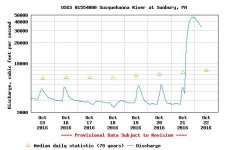
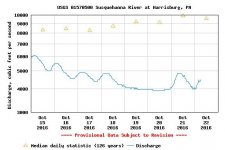
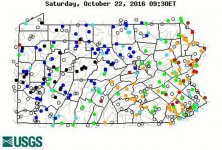
Looks like Northern PA will get some much needed rain.


http://water.weather.gov/ahps2/hydrograph.php?wfo=ctp&gage=cedp1
 
So they are predicting peak flow of 11.1 kcfs.

But what does kcfs mean? I haven't seen that term before.

A kilogram is 1000 grams.

If kcfs means 1000 cfs, that would equal 11,100 cfs.

But the max recorded for that gauge was much less than that.

So maybe it means kcfs means 100 cfs? In which case they are predicting 1110 cfs. That seems much more likely.

 
k is definitely a thousand. I think they are off by an order of magnitude on their scale.

But Pine will still be well below flood stage. It (and the rest of the state) are just so low to begin with.
 
salmonoid wrote:
k is definitely a thousand. I think they are off by an order of magnitude on their scale.

But Pine will still be well below flood stage. It (and the rest of the state) are just so low to begin with.

I think you're right. They are off a decimal place. It should read 1.11 kcfs.

Or, much better, they should just list it as 1110 cfs. That's simple and user friendly.

If Pine does go up over 1000 cfs, that will be nice. That will put some water in all those wild trout tribs in the region.


Actually, after further review, I think the 11.1 kcfs is accurate. The historic max for today is 7490 cfs (7.49 kcfs). So that is not not much more than the historic max for today. Historic max overall is 66,000, so I'm not sure what number you were looking at that shows 11,100 as being much over the max.

http://nwis.waterdata.usgs.gov/pa/nwis/peak/?site_no=01548500&agency_cd=USGS
 
salmonoid wrote:
Actually, after further review, I think the 11.1 kcfs is accurate. The historic max for today is 7490 cfs (7.49 kcfs). So that is not not much more than the historic max for today. Historic max overall is 66,000, so I'm not sure what number you were looking at that shows 11,100 as being much over the max.

http://nwis.waterdata.usgs.gov/pa/nwis/peak/?site_no=01548500&agency_cd=USGS

I was looking at the historic max for today. And didn't see the historic max overall.

11,100 cfs? That's a lot of water. The streams will be roaring. And it's been awhile in NCPA.

 
If it does go to 7.3 feet that equals 11,000 cfm. In 1972 during hurricane Agnes, it went up to 16 feet and 66,000 cfm, not sure if that's the all time high but it's pretty close. The camp I stay at is only accessible by boat and years ago I crossed Pine in a canoe at 6 feet, wouldn't do it again. At that height, you have white caps on the water.
 
SWPA is getting the rain we need. Standing water in most low spots, especially on the roads. Creeks are blown out and look like chocolate milk.
 
We got hammered, some pretty bad flooding on Loyalsock and Lycoming creeks. More rain on the way. State College area in bad shape too. We really needed rain, but not this.
 
It's been a sharp SW to NE cutoff so far. For instance, look at the gauges on Spring vs. Kish.

Good rain for Potter/Tioga though. A good portion of it should make it to the aquifer as well given that trees are dropping their leaves.
 
Not much rain in Benton. Raining now but we didn't get hit by the large batch of rain that went through.

Ron
 
Well, in southern Blair Co., we got next-to-nothing, and we really need some. I'd have liked at least a couple of inches, but not here.
 
A hair over 2" at the USGS rain gauge in Natrona
 
Nothing at penns???? Hopefully that new brick work at milesburg got washed away.
 
ryansheehan wrote:
Nothing at penns???? Hopefully that new brick work at milesburg got washed away.

What brickwork?

I looked at Bald Eagle Creek at Milesburg today. I didn't see any flooding, but it was close to bankfull.


The brickwork ryansheehan is referring to is probably the brickwork along Spring Creek upstream of the Lamb's Crossing Bridge in Bellefonte to the bridge at Tallyrand Park.
 
FrankTroutAngler wrote:
The brickwork ryansheehan is referring to is probably the brickwork along Spring Creek upstream of the Lamb's Crossing Bridge in Bellefonte to the bridge at Tallyrand Park.

Yup, this one, guess it's not brick, miss the old abandoned building.
20151226_092457_zpsq4wsudyd.jpg
 
Amazing rain storm. Susky ^ 50,000 in Sunbury, yet 4,000 in Harrisburg. It will reach soon.


Precip Amounts
 

Attachments

  • Sunbury.jpg
    Sunbury.jpg
    35.7 KB · Views: 2
  • H-Burg.jpg
    H-Burg.jpg
    32.9 KB · Views: 4
Looks like the larger trout streams in NCPA have peaked and are dropping. Although too much rain in one shot, my guess will be that the watersheds drain down pretty fast.

Looking at our USGS colored dots map. . . it's strange to see western PA blown out and eastern PA still orange and red.
It seems so much more typical to see it the other way around.
 
Yep...flooding west / drought east...kinda crazy.


Attachments

  • PA stream levels.jpg
    PA stream levels.jpg
    283.6 KB · Views: 3
Back
Top