JakesLeakyWaders
Active member
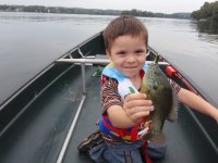
I took my oldest boy for another boat ride today in the motorized super canoe on the river. Right now with all this low water it is about the best place to go without having to worry about the motor hitting rocks.
Conditions were overcast and I figured fishing might be ok before this huge storm system rolls through. We both fished with bead head wooley buggers. The water was very clear and we caught lots of pumkinseeds, red breasted sunnies, and a redeye. No bass however I saw lots of largemouth between 5-9 inches near boat docks and weeds.
Putting along just offshore I spotted one sunken pontoon which was tore open adjacent to a large sunken tree in about 7-8 feet of water. We putted around the spot just 60 feet out from a boat dock and caught nice sized sunnies one after the other. I made a mental note of which island cottage # the structure was infront of.
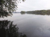
Stopped off at Goodling Island for a pee break. It is a small island picnic area with benches, grills, and even mowed grass. Has a nice boat dock too. Didn't catch any bass today but seen quite a few. They are not as willing to bite as the sunnies and my kid makes a lot of noise in the boat.
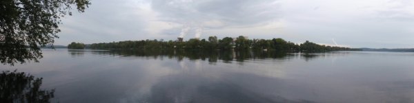
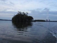
In the panoramic photo I am facing east on an island in mid-river, in the foreground is the river of course with Shelly Island across the center of the frame and Three Mile Island is obscured in the background behind Shelly Island.
Lake Frederick has at least ten Islands ranging from 200 ft. long, on up to 2 and 3 miles long.
Note:
In the picture of the cooling towers if you enlarge the picture you can see there is a tree just below the left tower with about 20-30 white herons in it. This tree is on the tip of battery Island.
Conditions were overcast and I figured fishing might be ok before this huge storm system rolls through. We both fished with bead head wooley buggers. The water was very clear and we caught lots of pumkinseeds, red breasted sunnies, and a redeye. No bass however I saw lots of largemouth between 5-9 inches near boat docks and weeds.
Putting along just offshore I spotted one sunken pontoon which was tore open adjacent to a large sunken tree in about 7-8 feet of water. We putted around the spot just 60 feet out from a boat dock and caught nice sized sunnies one after the other. I made a mental note of which island cottage # the structure was infront of.
Stopped off at Goodling Island for a pee break. It is a small island picnic area with benches, grills, and even mowed grass. Has a nice boat dock too. Didn't catch any bass today but seen quite a few. They are not as willing to bite as the sunnies and my kid makes a lot of noise in the boat.
In the panoramic photo I am facing east on an island in mid-river, in the foreground is the river of course with Shelly Island across the center of the frame and Three Mile Island is obscured in the background behind Shelly Island.
Lake Frederick has at least ten Islands ranging from 200 ft. long, on up to 2 and 3 miles long.
Note:
In the picture of the cooling towers if you enlarge the picture you can see there is a tree just below the left tower with about 20-30 white herons in it. This tree is on the tip of battery Island.
Attachments
-
 Nate pumkinseed river.JPG622.8 KB · Views: 21
 -
 Sandy & Shelly Islands from Goodling Island.JPG586.7 KB · Views: 20
 -
 Susquehanna River from Goodling Island.JPG449.5 KB · Views: 19
 -
 TMI with Beshore Island in foreground.JPG655.1 KB · Views: 24
 -
 Nate swingin on sign.JPG801.7 KB · Views: 22
 -
 Battery, Shelly & Three Mile Islands.JPG594.5 KB · Views: 22


