info needed on drifting and camping on Lehigh River

salmo-trutta

salmo-trutta

Member
Joined
Mar 17, 2015
Messages
98
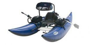
I just got a pontoon and am very excited to do some drifting. I have been reading about the Lehigh River and would like to do some trips there. Having never fished it, I have several questions if anyone can help.

1. In reading about the stream it sounds like starting at the dam, there is some white water that I may want to stear clear of. My pontoon is the Outcast, Fish Cat 10-IR (10 ft). Is there water I should stear clear of? If so, how far down stream should I go before I start a float? Where would the first place to put in be?

2. Are there put in and take out areas that make for a good full day float? If so where?

3. What about tent camping in the area? Any sugestion.

4. What about a shuttle service. Is there anyone that shuttles a vehicle down stream on the river? I'll probably be alone so I need to find a shuttle service.

5. Any other things I should know?

Thanks for any advise guys?
 

Attachments

  • 2015-03-19 17.21.27.jpg
    2015-03-19 17.21.27.jpg
    50.4 KB · Views: 14
I'm not a Lehigh River regular so perhaps some folks who know it well will chime in.

In the meantime, if you haven't already done so, the PFBC website has float/canoe trails with info about access. They're a good resource to check out:
Lehigh Trail
 
I may be wrong but I believe the heaviest Rapids are from below hickory run to Jim Thorpe, which is more or less the lower Lehigh gorge area. I've also been told by one of the guys at a&a outfitters that they only float from the dam to rockport which is roughly 4-6 hours. I don't think any section of the gorge is going to be an easy float, it's more for kayaking and rafting, but I'm sure it can be done as I've seen a guy do the gorge in a canoe. Honestly I would go Jim Thorpe downstream, especially if you're by yourself.
 
The last sentence in the above post is GOOD advise!
 
Thanks guys
 
Yep, if you are going by yourself I would not do the gorge. Stick below Jim Thorpe. There really is only 2 sections below there that I know of can be kinda rough. The worst is a mile up from the Bowmanstown Bridge. The other is at the horseshoe at Palmerton. That one isn't really that bad but you will get wet.
 
Don't try the gorge. My brother and I canoed it, White Haven to Jim Thorpe, but only because we didn't know any better.

Never again. It's very rough. We hit a lot of rocks. A dangerous day on the water.

Regarding camping, I think the campground at Hickory Run State Park is nice.
 
hickory run state park is really nice and close to the tannery access to the trail. do not float gorge alone, especially early in the season. wading in the gorge can be very tricky as well. big slippery rocks, fast water and sudden drop offs. I would even discourage fishing the gorge alone. I have had good luck fishing below rockport accessing by riding the bike trail downstream.
 
I always heard that the Upper Gorge was of limits to anything but rafting/kayaking, but it appears I was told the wrong thing, possibly by someone who didn't want fishermen floating.
But this is what the water trail says.
The Lehigh River Water Trail is 72-miles long, starting at White Haven and ending in the city of Easton at the Lehigh River’s confluence with the Delaware River. There the traveler can continue down the Delaware towards Philadelphia and beyond to Delaware Bay.
Northern Section
This 41-mile segment of the Lehigh River Water Trail begins at White Haven at an access to the Lehigh Gorge State Park and ends at the Lehigh Gap at Blue Mountain at the Carbon-Lehigh-Northampton county line. Deep gorges and fast-moving water characterize this section of the Water Trail. Substantial canoeing or kayaking experience is required to maneuver most sections this reach of the river. It contains several access points and traverses 26 miles of the Lehigh Gorge State Park.
Southern Section
This 31-mile segment of the Water Trail begins at the Lehigh Gap at Blue Mountain at the Carbon-Lehigh-Northampton county line and ends at the confluence of the Lehigh River with the Delaware River in the city of Easton. This reach of the Water Trail widens out and tends to become more leisurely than the northern section. The land around the river is characterized by rolling hills and forested riparian corridors. The river contains numerous access points and passes through the urban centers of Allentown, Bethlehem, and Easton.
 
Thanks for the info. Very helpful.
 
Anyone know of anyone who has shuttle service in the area to shuttle vehicle down stream?
 
I know of none. Hit me up and if I am available I can usually help. I have done it for other members.
 
Just some advice. The Lehigh is a dangerous river for novices and is really dangerous to even wade in many places in the gorge area.

Also, there are "whitewater" releases during the season that live up to their name. On the other side of the coin, during the low water periods, a pontoon will chafe on rocks and mini-portages are necessary. Chances are good to puncture a pontoon or break a paddle or oar on a float.

Long and short, I would not recommend to someone buying their fist pontoon and not knowing the River to float the Gorge section.

(In fact Shane keeps a body bag in his trunk.........just in case) :-o
 
I actually just heard that someone swamped a clack just recently on the lehigh - above bowmanstown. Regardless, the Lehigh is not a river to take lightly.

Unfortunately, there are no shuttle services that I know of.
 
I agree with the other posts. I would get some run time in before hitting the Lehigh. I have done Glenn Onoko to Bowemanstown twice. I would make sure you have a spare oar, good sure lunch, a decent patch kit, a hand pump, and a decent dry bag with a phone for emergencies.

I would try to float with Guys like Krayfish and such and learn the water. I did a guide trip and had him teach me about the water and fishing. LOL Great money spent. Seriously though, I had a slight riffle on the Shenandoah derail me badly one day just by catching a piece of a tree in the water. It pinned me up against the tree in a very easy piece of water and almost flipped the three of us on the boat. It does not take much. Especially with a smaller boat.


Thanks Becker. I hate to impose, but Ill see what I can do and maybe take you up on your offer....or we could fish together if you have a pontoon also.

Steve
 
Lehigh, Yough and many other waters..... no experience floating, not knowing flows and danger areas increases the chance that you'll simply be a statistic / recovery effort.

Shane, PhilC and beeber2 float the Lehigh pretty often. I'd suggest getting together and doing a few educational floats with them prior to venturing out on your own. You need to learn the spots to put in / take out, understand the flows, releases and gauges so you can determine if the river is going up, going down, if the feeders are adding volume and turbidity, etc. All of that will come in time.

To Charile's list, I'd also add: quality duct tape, tear aid, uv aquaseal, knife, rope and spare oarlock.

A forum member and his dad set out for a float on the WB one day. They never went down it before. They simply picked spots on a map and set out on their adventure. They expected around 6 hours on the water. I understand the river miles / flows and would estimate the chosen float to be closer to 12 hours. In addition, seat on boat broke and caught in hellish hail storm. They ended up halfway to the destination, walked out to the road and thumbed a ride to their car. You don't want to be "that guy". Dragging a boat 4-5 miles is an awful experience. I've towed another boat downriver for 5 miles and that also sucked.

Until you get familiar with the rivers you intend to float, you really shouldn't be pulling any solo flights. What looks awesome to you may be so low it will be a dragfest for 3 miles.... or..... it may be dangerously high and you don't realize it.

As I mentioned before, you are welcome to join me on the Delaware as I've floated 400 - 500 river miles over the last couple of years. I also float the Susky or Juniata a few times in the summer and you're welcome to join in there as well.

According to others, I seem to have a hazing process for new floaters (10 - 12 miles in windy conditions). I don't do it on purpose as it's almost always windy up there and sometimes the floats selected are fairly long. That's just me trying to get someone over to a section that they haven't seen and I know the conditions will call for 9 hours of rowing and 1 hour of fishing. LOL. Nothing will beat the torture test I put DaveS through on the lower EB one spring. Maybe he still have the video which sounds like we are standing behind a jet taking off. Whitecaps 3' high, etc. Good thing it was only 13 miles. LMAO

 
Unless you're an experienced whitewater rafter, canoeist or kayaker then from the White Haven access to the Glen Onoko access you DO NOT want to paddle here. Besides there certain special requirements from DCNR & PFBC for your watercraft too in order to float that length too. This is the Lehigh Gorge proper. I'm not sure I'd put in at the Dam to White Haven either, at least not until you gain some experience on this river. From Glen Onoko all the way to Slatington and even all the way down to Cement on is over 30 miles of great water to float. A great first float is Lehighton to Bowmanstown or Bowmanstown to Slatington. Or even Glen Onoko to Lehighton or Jim Thorpe to Bowmanstown, these latter two will each give you a little whitewater to experience as well, nothing like the gorge though.
 
Thanks. I agree. This is good information.so with all that, are there big trout in those areas. I not just looking for a seanic drift.
 
What to you consider big trout? If you are talking 16-20.... there's a ton of places with fish like that but you have to know where to look. if you are talking 20+, there's quite a few places where you can find fish like that too.

I doubt anyone will give up their big fish honey hole on the internet. That is only something you'll have shared after fishing with someone and gaining their confidence. Just sayin.
 
Back
Top