fishing using bedrock geology: pottsville bedrock

k-bob

k-bob

Well-known member
Joined
Jul 29, 2009
Messages
2,371
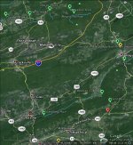
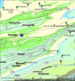
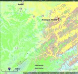
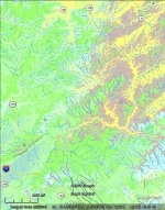
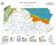
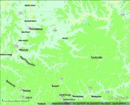
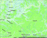
Fun images, area near western border of Potter. Bedrock colors are Pottsville = lime green; Huntley Mtn = redbrown; Catskill = lemon yellow. Blue squiggles are class As. Geology isn't the only thing involved, but looks like more class As when streams start in Huntley and Catskill in Potter, versus when they start in Pottsville further west.

Pottsville is low buffering bedrock that may have relatively high aluminum levels. pfbc: "Kocovsky and Carline (2006) noted that streams with underlying Pottsville sandstone geology were the most problematic in retaining wild trout populations. This was due to the lack of buffering capacity from previous acidic episodes, the leaching of acidic materials, and the leaching of aluminum during precipitation events."
 

Attachments

  • pvill12.jpg
    pvill12.jpg
    133.8 KB · Views: 18
it's not that there are zero trout in most of that Pottsville bedrock area. here is nat repro...

just looks like there are fewer class As, as seen in the first image above, in the green pottsville than you might have guessed.
 

Attachments

  • pv21.jpg
    pv21.jpg
    146.8 KB · Views: 7
some anf areas have Pottsville bedrock and acidity problems in streams that otherwise look promising... see raven run story here:

http://www.patrout.org/docs/newsletters/patrout_winter2014.pdf?sfvrsn=2
 
Geology is definitely a huge factor. Even with no additional acid in the rain from human activity, many of those streams would not be class A. But some of the completely baron streams would at least have some trout.

Like the article said, "clean rain" only has a PH of about 5.8%. Brook trout can live in that and even lower, but at that level reproduction is likely already impaired, not to mention fertility of the stream. I have no idea how the calculated "clean rain" since there is no such thing, but I'm willing to take their word for it.

The general rule in NWPA is that the very few class As that exist are in previously glaciated areas where buffering material was drug here by glaciers. Most of the Allegheny plateau was not glaciated and hence very little buffering (pottsville bedrock). The areas mentioned in the article are prime examples as is the Salmon Creek headwaters in the ANF. IN some cases the natural geology even contributes to acidity.

Here is a map of glacial deposits. Notice how well this also fits your maps.

The moral of this story is that there are no trout in the ANF, so please don't even bother fishing there. (kidding of course).

Here is a link if you want to see a larger map.
 

Attachments

  • GlacialDeposit.jpg
    GlacialDeposit.jpg
    120 KB · Views: 4
Pottsville bedrock doesn't seem to increase the chances of class A streams. Here's the area around Pottsville. Pottsville bedrock = lime green. Mauch Chunk bedrock = beige band, with marked class A streams (for ex., tumbling run and trexler run). In second (satellite) image, you can see that the area with a lot of Pottsville bedrock, for ex., just west of tamaqua and below 81, looks quite trouty. But it doesn't seem to have class As.
 

Attachments

  • pv33.jpg
    pv33.jpg
    138.1 KB · Views: 6
  • pv43.jpg
    pv43.jpg
    114.1 KB · Views: 9
k-bob wrote:
Pottsville bedrock doesn't seem to increase the chances of class A streams.

Correct (IMHO). It most likely decreases it. I was agreeing.

I think most of Forest County is Pottsville bedrock and I think it has zero Class A, maybe 1. I didn't look at the list. However, most of it's streams do have some brook trout. I think Forest County is a good comparison to the area you are looking at since Forest County is mostly Pottsville bedrock. I could be wrong, but similar at least.

You can find a huge map here for the whole state, but I think they use a different color for "Pottsville group."

Interesting subject.

 
right I didn't write clearly and realize that you also see Pottsville as a bedrock that can be a minus for trout.

yeah my map has different bedrock colors. I like the state bedrock map but it doesnt have fish info. to get class a, nat repro, and bedrock geology all in one map, I used Google earth. I didn't see a kml/earth version of the dcnr bedrock map, I used a USGS one and tweaked the colors for Pottsville, Huntley, Catskill, Mauch so those areas are clear...
 
right, forest county is heavily Pottsville (green), and while there are many nat repro streams, there is only one class A.
 

Attachments

  • fc1.jpg
    fc1.jpg
    94.4 KB · Views: 6
  • fc2.jpg
    fc2.jpg
    134.9 KB · Views: 5
And that one very small class A was added only a few years back and is more of an anomaly. Also, there isn't very much of it on the Pottsville bedrock. Salmon Creek watershed is very close (over the hill), and drains a large area of the plateau. It rather sucks as far as natural reproduction. The best you will find in that watershed is probably class C with most being worse.

I forgot to add the link, but apparently you already saw that one.

link

Here is another interesting map of PA that I find useful. It shows various geological periods of the "surface" bedrock.

link

I'm only an amateur at this stuff, so keep that in mind.

Carboniferous period is when huge amounts of carbon were sequestered in the form of coal. It consists of Mississippian and Pennsylvanian with Pennsylvanian being the latter part. Mountain building also occurred during the Pennsylvanian geological period.

Pottsville bedrock group was formed during Pennsylvanian and would explain why it has rather poor buffering capabilities. It tends to be naturally acidic all on it's own.

There is "some" limestone associated with this period to the west, but not typically in the rest of it.

Limestone in PA is more associated with shallow seas that existed before the carboniferous period.

I'm just someone who has always taken an interest in geology. I did take 2 or 3 geology courses as electives in college, but mostly just treat any conclusions I may have implied above as educated guessing. I works for me.
 
I have zero geology training. But we are used to the ideas that 1) PA has acidic rain, 2) different rocks/soil can neutralize it to varying degrees (limestone), and 3) this affects trout. Pottsville bedrock (pfbc quote in OP) seems to stand out as low acid neutralizing and prone to leaching aluminum that is known to damage trout.

I love the state bedrock map in first link previous post, but that map doesnt have trout stream listings, such as class A and nat repro. I'd like to add that bedrock map to google earth, where I have the trout listings, but I only see ways to use it in a different map viewer (arc GIS). I am more used to google earth.

there is a great free usgs pa bedrock map in google earth format ("kml"). It works well. But its default colors for various bedrocks don't work for trout - for example, catskill and burgoon, which may be different for trout, look like the same color. So I used the usgs PA bedrock kml in google earth, and changed the colors it displays for pottsville to lime green :)
 
k-bob wrote:

I love the state bedrock map in first link previous post, but that map doesnt have trout stream listings, such as class A and nat repro.

True, but I already knew were the trout streams are in the areas I was looking at.;-)

 
"True, but I already knew were the trout streams are in the areas I was looking at."

Funny and this happens to me also! Maps below show the class A streams around Pottsville PA. They aren't in Pottsville bedrock (green), they are in Mauch Chunk (tan). And Tumbling Run right by the town of Pottsville (but in Mauch bedrock)? Listed as class a brookies, pH is so high that it's now browns :-o


Attachments

  • pv3.jpg
    pv3.jpg
    117 KB · Views: 8
  • pv2.jpg
    pv2.jpg
    142.1 KB · Views: 5
K-Bob,

The Forest County area I know very, very well. The Pottsville bedrock (lime green) sucks. Not only not class A, but very poor trout populations in streams which spend any considerable time in that zone. Yes, some are on the natural repro list, but catching wild fish is fairly rare, despite seemingly good temps and structure.

The whitish color, there, though tends to hold good streams. Still not class A, but much, much better.

The SW to NE stripe that separates majority green from majority whitish is Tionesta Creek. It has long been noted that the tribs from the south tend to be poor while the tribs from the north tend to be good. Likewise, most of the direct Allegheny tribs tend to be good fishing, and that's despite poorer structure and sometimes borderline temps. All the "island" designations follow the Allegheny.
 
pat: "The Pottsville bedrock (lime green) sucks. Not only not class A, but very poor trout populations in streams which spend any considerable time in that zone. Yes, some are on the natural repro list, but catching wild fish is fairly rare, despite seemingly good temps and structure."

thanks. your experience seems to fit w/ pfbc quote on Pottsville streams in OP: "problematic in retaining wild trout populations."

I have never fished out there. But around the town of Pottsville, Pottsville bedrock seems less good than Mauch Chunk bedrock...

pat: "The whitish color, there, though tends to hold good streams. Still not class A, but much, much better."

it's Shenango bedrock, don't know much beyond that...
 
The Shenango bedrock is listed as sandstone, siltstone, and shale.

The Pottsville bedrock pretty much the same, but add coal.

Now, I don't know that all sandstones, siltstones, shales, etc. are the same in terms of water chemistry and buffering. They probably aren't. Siltstone pretty much means a sedimentary rock composed of silt. But silt itself is fine grained soils, and the mineral contents are those that eroded from whatever bedrock they came from.

But aside from that, I could very easily see the culprit being coal. It tends to have plenty of sulfur associated with it. And that makes sulfuric acid. Same mechanism as acid mine drainage, from, of course, coal. Though in that case it's artificially concentrated by exposing the coal to water in much greater abundance than is natural.

Even if the sulfuric acid leaching from natural unmined coal is not enough to single handedly ruin a stream, over time, it's certainly possible that it quite naturally used up any buffering capabilities of the sandstone, siltstones, and shales that it's associated with, leaving those areas vulnerable to acid rain. Where-as without the coal, some buffering minerals remain in those same rocks to help combat acid rain.
 
The last key I would look to in identifying a worthy stream would be bedrock formation. Hydrology, on the other hand would be primary. Though the bedrock geology may indicate the likely "hydrological" features of the stream, as demonstrated by the comments here, it is far from a definitive indicator.
 
Sure, bedrock info is not definitive. No one variable is. We have a long list of natural repro streams. With maps, you can get drainage area, gradient, and bedrock. If you're choosing to a new stream to try, each one of these pieces of info can add value at least some of the time. Bedrock, for example, is connected to pH, which is important.

You won't know as much from maps as you would from fishing experience. But targeting Shawangunk, avoiding Pottsville, etc., has worked for me when trying new streams

http://www.ncbi.nlm.nih.gov/pubmed/18258282


Aside from the coal which Pat talked about, There might be slight differences in buffering capabilities between Pottsville bedrock, and Shenango (generally speaking). Both were formed during the Carboniferous period with Shenango being older. I'd say neither are all that good as far as buffering, but Shenango might be slightly better.

As far as the Tionesta Creek area north and west, there may be additional factors involved as well. Some of Shenango bedrock as you go further in that direction may have been influenced by shallow seas more so than Pottsville which lends to more limestone. That could explain why there is less coal there as well.

It's an interesting period in earth history if you find rocks and geology interesting. Lots of stuff happened in this part of the world during the later Carboniferous which tend to mean less acid buffering capability in those rocks today.

You are also getting closer to the areas that were glaciated as you head North and West. and the till contributes some buffering. I'm not sure that would come into play North of Tionesta Creek, but I think it might as you get closer to the NY border and over near the Allegheny. And Tionesta Creek and the Allegheny are not all that far apart in the area where Pat is taking about.

Again, these are just more educated guesses.


JackM wrote:
The last key I would look to in identifying a worthy stream would be bedrock formation. Hydrology, on the other hand would be primary. Though the bedrock geology may indicate the likely "hydrological" features of the stream, as demonstrated by the comments here, it is far from a definitive indicator.

Correct. The geological maps are not a great tool to tell you the best places to fish, but they are good tools to explain why.

Some don't care about why, some do.

If one is simply looking for instant self gratification, one should just use the cheat sheets that the Fish commission provides, or read somebody's book describing the streams.
 
EZ-find Sharpe paper shows that most small Pocono-bedrock streams in Laurel Hill PA had ST, while most small Pottsville ones did not. If you were to fish 'round there, really so hard to improve your guesses using that info?
 
Back
Top