Devil’s Hole Creek

The ruins are an old ski lodge. I know the legend is speakeasy. But you can see the wheels on trees for the lift wire. And internet sleuthing I saw an old ad for it.
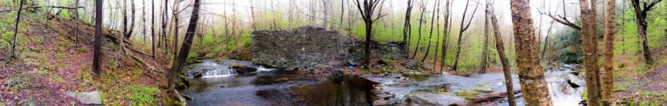
I'd love to see that ad and know the name of the "lodge" because I know the location well and looking at topo maps all the way back to the 1920's, there were no structures indicated or any roads leading down to the location, just trails. I also wonder IF the place had electricity, how did it get service down that ravine?

Some Internet sources claim the "resort" went out of business in 1950 due to a fire on the Delaware Lackawanna & Western RR however, those tracks are quite a distance from the ruins so the fire would have to have been massive and I never found any evidence that a fire that size happened.

The dam and reservoir near the railroad tracks were also still in place in 1950 (until Hurricane Diane blew the dam out in 1955) so that also makes the spread of a fire from the tracks that far upstream less likely. Other sources claim whatever the structure was, it was obliterated during Hurricane Diane which makes more sense.

I also perused a 1949 phone directory for Cresco & the Pocono region and came up with no mention of a resort with the likely name "Devil's Hill/Hole" or "Seven Pines," a name suggested by another source because that is the actual name of the mountain above the "hole."

Obviously it could of had a different name, but of the resorts ads I found in the region in 1949 that weren't places I was already familiar with, none mention fishing the creek or skiing as "activities," which leads me to believe it wasn't a resort and was already abandoned by 1949.

I've seen the "wheels on trees" and the tow line shack which have been described as for old tow ropes, but there really aren't any cleared areas that appear to have been ski slopes. It seems more likely to me they were used to lower the building materials used to build it and possibly bootleg hooch and other goodies and patrons down to the "lodge.

I am still trying to figure out what it was, was it more that one thing and how people got down to it...
 
I bagged work on Thursday May 19. I live way down in South Jersey. Because of the heavy rain Wednesday night-Thursday morning I almost did not go. Got to the stream with a friend of mine from the Bethlemem area. It was still raining lightly when we arrived. Air temperature was around 56 with grey skies. The creek had a good flow and was not colored up to any noticeable degree. Water temperature was a cold 48. I started fishing nymphs. And hooked up in the first hole. I continued fishing upstream hitting all of the pockets and holes. As the skies cleared the bugs started to come off: tiny, tiny BWOs, several small caddis and a few spinners. The surface activity was minimal. I did really enjoy the Yellow Sallies as they hatched. Beautiful and bright yellow. The were a size 16. I never noticed before how segmented the flies are. Turning to a dry elk hair caddis earned me several strikes, but no takes. Air Temperatures remained in the 60s most of the day.

I fished my very old Sage 8’6” 4 weight. All fish taken on nymphs. I fished 2 in tandem. Most of the damage was done on a bead head sexy Walt’s size 16. Not a lot of fish but a beautiful experience especially watching the yellow stoneflies hatch. Nobody else on the stream. To cap the day, on my way back to my car a handsome black bear crossed my trail in front of me about the distance from the pitcher’s mound to home plate (might be time for a new pair of Jockey shorts!).

I did notice that all of the fish I caught were much smaller than when I fished the creek 2 years ago using dry flies.

As I packed up and celebrated with a Cape May IPA I was a pretty happy city slicker.
nice report
 
I think there’s pretty strong consensus the ruins are an old ski lodge. Not in the sense of a big commercial outfit, but more of a club. Think like a hunting or fishing camp, but for skiing.

Check out some LiDAR maps of the hill to the NW of the ruins. Can plainly see many grades (slopes?) cut into that hillside that intersect with one another. There’s been plenty of enough time for them to be completely reforested over now, but the grades are still there.

The ruins, aren’t really all that old, relatively speaking. I think I remember electrical conduit, so I suspect it had electricity. Wouldn’t have been all that hard to get it down there from the W or NW along one of the ski grades, or the one with the tow rope system along it. I think I recall that one basically being a straight shot up the hill and you can still make it out pretty well, though it’s grown over with trees now. I definitely remember an oil fuel storage tank in the basement so it probably had an oil burning furnace and/or boiler. Been a while but I think I recall a cinder block foundation? Add all of that up and it likely means 1930’s - 1940’s construction.
 
Last edited:
How they got there is easy. There's a freakin road. The hiking trail you walk up along the stream? Yeah, that was a road/driveway, clear parallel tire trails in many places, and graded fords where it crosses the stream.

Yes, it had electricity. At least, there's electrical conduit in the ruins, and one or two poles remaining along the road in. I can't speak for whether that was original when it was built, or added at some point as a remodel. There's also a tank, maybe a boiler or an oil tank, not sure. There are also smaller, less obvious ruins at the bottom of the hill along the lift trail. It was a tow shed. Yes, there are graded paths coming down the hill on both sides, with younger trees. Remember, it was abandoned 70ish years ago. Let any thin trail in the woods grow for 70 years, and there will be some sizable trees on it!

Don't get me wrong, I find it likely this place existed during prohibition, there's nothing saying it can't be a ski lodge AND a speakeasy with illicit alchohol. A private ski club in a secluded valley where you can see everything coming seems a likely place to run a speakeasy in an era where they were common. But it pretty clearly at least had the cover of being a ski lodge. You looked in a phone book. A lot of places didn't have phones!!!
 
Last edited:
How they got there is easy. There's a freakin road. The hiking trail you walk up along the stream? Yeah, that was a road/driveway, clear parallel tire trails in many places, and graded fords where it crosses the stream...
How come that freakin road doesn't show up on topo maps and where it it access other roadways, dirt or otherwise??

Even IF it is the hiking trail that more or less begins on the east side of the creek, as Devil's Hole Road was the ONLY road into the 1930', the freakin road would have had to get around the impoundment and dam, and crossed the DL&WRR tracks, all not visible on any topo map from the era I have seen.
 
As for that specific road, I don’t know. But there are countless road grades all throughout the woods in PA that don’t show up on topo maps.

Some were logging roads. Or private lanes to cabin at one time. Or logging roads that turned into private lanes to a cabin, etc.

No way to know. But the “trail” to the ruins in DH was definitely a “road” of some kind at some point. Whether on a map or not. Even if nothing more than a lane to get back to that lodge.
 
I couldn't find my pics of the old ski lodge but here is the "old mill wall". Love hand stacked stone. Lehigh River has some great sections as well. I'm only assuming all hand stacked and the stones along the LR are quite large. Maybe they had machines but I like to think it as all muscle craftsmanship.
 

Attachments

  • 20130509_124856.jpg
    20130509_124856.jpg
    94.8 KB · Views: 55
I saw this interesting structure at the lower end of the creek where I accessed it. I was on the cusp of posted land and can't remember exactly where this is.

IMG 3674
 
If that's not too far upstream of the RR bridge over the creek, I BELIEVE that is the remnants of the dam that blew out in 1955.

I'd say that location is fairly accurate. Thanks for the additional!
 
Back
Top