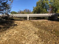
Since those are my pictures, I guess I should chime in. If you wish to look it up on a map, the bridge in the picture is the Main St bridge in Tatamy, pa.
https://www.google.com/maps/place/40°44'32.6%22N+75°14'59.1%22W/@40.742382,-75.2502932,19z/
Note that this is below the confluence with the Little Bushkill creek, so we are losing the entire flow of that tributary as well when this happens. Roughly a mile and a half of creek dry up during these events. Below a certain point additional springs add flow to the creek and the creek continues to flow (at a reduced amount) through these events. Forks of the Delaware chapter of Trout Unlimited has been dealing with these issues for a lot longer than I have been involved with the chapter, and we will continue fighting on behalf of the watershed.
To respond to some specific comments in this thread :
drakeking412 wrote:
From a geologic standpoint I would say that the while the quarry might only get 10% returned sinkhole water I'd wager that quarry operations opened up more sinkholes than thought but that's just speculation
Yes, there is quite a bit of sinkhole activity in the area. What makes it complex is that sinkholes occur naturally in limestone geology. Sinkhole activity can become increased within the cone of depression of a deep quarry, as appears to be the case with this quarry. Connecting correlation and causation is not always a simple matter when the quarry operators can point to a history of sinkholes predating the quarry. In this regard, the die test result is significant.
drakeking412 wrote:
the lining of the stream is stealing from Peter to pay Paul and just like they pointed out the problem is likely to just move.
I question whether building that concrete structure on top of known sink holes will even hold up? I'll confess I'm not an engineer or a geologist, though.
Baron wrote:
Historically this stream does this and I believe long before the quarry
I'd be interested in reading up on this if you could point me to some sources.
Baron wrote:
I thought I had heard that over the years the quarry was assisting the stream flow in being more steady and able to support wild trout.
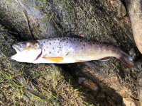
The lower Bushkill is fed by springs. It supports wild trout in spite of quarry operations.
Baron wrote:
Can someone research this.
Please do and share what you learn.
Baron wrote:
Why not re-route the streamed to bypass the quarry?
The stream does not run through the quarry. Where would you propose routing it? Keep in mind you would also need to reroute the Little Bushkill.