You are using an out of date browser. It may not display this or other websites correctly.
You should upgrade or use an alternative browser.
You should upgrade or use an alternative browser.
Bridges and streamwork
- Thread starter JeffP
- Start date
JeffP
Well-known member
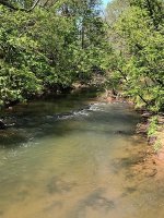
What you can't see so well is that the better part of the pool is to the left. It's nice to the right but I can't believe it won't erode that bank. There is more upstream you can't see. It looks a lot like the work that was done on the Hammer between Snavely's Mill and Brunnerville. Fantastic deep swirling pools. There is so much fishable water but the locals claim it ruined the fishing. I think they are most likely talking about largemouth that use to be in the pond-like but heavily eroded pools. This section does not seem to be eroding at all. I'm not sure if it's the science being used or the heavy clay in that stretch.
lycoflyfisher
Well-known member
- Joined
- Apr 15, 2014
- Messages
- 1,481
Can you describe what we are seeing? I do not see anything that would be called a stream improvement device? Perhaps there was a gravel bar that was removed or the channel was manipulated during construction that caused a new riffle to form. Typically, stream improvement devices such as rock vanes, jhooks, log vanes ect protrude into the stream angled upstream to deflect flow away from the banks.
JeffP
Well-known member
I think it would be considered rock vanes. The stream has been totally re-done for a ways up. It has to be more than just the result of the bridge construction. Next few pools are really nice as well. I may get out and get a couple more pics today.
JeffP
Well-known member
The rock continue the whole way across the stream. There is a decent amount of silt in the middle, but both ends seem to direct away from the middle. Definitely not an attempt at a dam but a lot of rock involved. Both sides are probably a lot deeper than it looks from the picture.
JeffP
Well-known member
Saw some on the fish commission website that look similar. It's more of a half circle facing downstream. Not quite the same shape, but not too far off.
GeneBeam
Active member
Comments on the picture.
It looks like a wall to keep the stream at the same height during normal flow. Also, the wall might be there to keep the water from undermining the bridge abutment and it look like there is one on the other side also. The abutments are what ties the bridge to the land and where the bridge structure is supported. If it is a single span bridge then, one end of the bridge is fixed to the abutment and the other end is allowed to move back and forth to account for the expansion and contraction of the steel and\or concrete. The picture is of a bridge not a box culvert. It might have been built that way to account for a 100 year flood flow which is much more water then normal flow and if the wall were not there the stream bed would be as wide as the bridge is from face of abutment to face of abutment. Which might make the stream to shallow to allow fish to get under the bridge. JMO.
It looks like a wall to keep the stream at the same height during normal flow. Also, the wall might be there to keep the water from undermining the bridge abutment and it look like there is one on the other side also. The abutments are what ties the bridge to the land and where the bridge structure is supported. If it is a single span bridge then, one end of the bridge is fixed to the abutment and the other end is allowed to move back and forth to account for the expansion and contraction of the steel and\or concrete. The picture is of a bridge not a box culvert. It might have been built that way to account for a 100 year flood flow which is much more water then normal flow and if the wall were not there the stream bed would be as wide as the bridge is from face of abutment to face of abutment. Which might make the stream to shallow to allow fish to get under the bridge. JMO.
lycoflyfisher
Well-known member
- Joined
- Apr 15, 2014
- Messages
- 1,481
Rock vanes are constructed in an a parabolic shape, the wings are sloped up as they extend up to the banks. The purpose is to direct flow to the center of the channel and establish grade control. They will usually develop a scour hole downstream. It is imperative not to build them too high that they act like a dam and prevent a barrier to fish passage.
JeffP
Well-known member
Just a couple points.I know TU does not do projects on Middle Creek. Also, Middle Creek down this far is a pretty big creek so I don't think fish passage is an issue. If I get out this week I will try to get a few more pictures.


