We're a week and a half out, so grains of salt and all that.
But.....
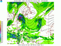
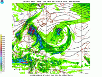
That hoped for tropical system. 97L currently predicted to become a hurricane (potentially a major cat 3 or 4) as it turns north/northwestward with very likely US landfall. At this range anywhere from New Orleans to Cape Cod is still possible, but the "center of the cone" has it scraping the Florida coast before making landfall in SC/NC region, tracking straight up through Virginia and into central PA.
This far in advance, that track WILL change, perhaps several times, so maybe being in the bullseye isn't a good thing. Nonetheless, here's your hurricane/tropical storm running almost due north through the eastern part of the country. Only question is whether it goes west, east, or over us.
Last 2 runs of the GFS, midnight run first and 6 a.m. run second. Notice lead times of 220-240 hrs. That'll get the chromers moving!