k-bob
Well-known member
- Joined
- Jul 29, 2009
- Messages
- 2,371
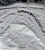
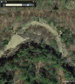
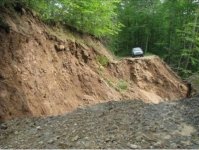
posted a less detailed version of this in another thread. this version has clear figures giving examples of stream development from logging to recent floods. worth looking up some geology terms to get a few of the ideas here imho ... scene in fig 25b for ex would have been lost on me, very interesting
https://gsw.silverchair-cdn.com/gsw/Content_public/Journal/geosphere/12/1/10.1130_GES01180.1/4/305.pdf?Expires=2147483647&Signature=FBU0iIsPUB~fWooZCI6Zdd7qG5~vDlkwROfouFc7aEfY0OxJkuYhHl0zt~B1LZhkVEWIwiFvUtDT6DEUTzAQfquc0rQ2RX67AVkBrJppB9Hl8473B5J27kd3M0eBMhgiUchchXcblYAQrjiDz0P2bqGjw6SJtyMP950u-gKM6cmCtU3-tTTX96OFUMc2-J2WdJ4kI1dMaSkvWUqhiGA1y0TTTmCJYc4fvmw6K5cAMFOX-ewyA1cL9utj7zRi57iLRzsh-uZq8LUrmOI-AjlH2cEReBRn-kGoa9RZX3ceOwTzp8Tci9ZA5YBSk2HJyLs9rwWhLC7AyD2L-44exB9B4g__&Key-Pair-Id=APKAIE5G5CRDK6RD3PGA
btw can look up any place in pa in the lidar land contour map that is used in in figure 19 easily here:
http://maps.psiee.psu.edu/preview/map.ashx?layer=1247
")


