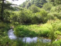
I am currently finishing a year long research project entitled PRE-EUROPEAN SETTLEMENT LANDSCAPE RECONSTRUCTION OF A STREAM VALLEY ON EAST BRANCH CODORUS CREEK, YORK COUNTY, PENNSYLVANIA AND IMPLICATIONS FOR STREAM RESTORATION. I have done carbon-dating and seed identification to recreate the valley bottom landscape before European arrival in North America. The stream systems in the region were very different then they are today. In fact, "restoration projects" do not come close to returning the regional streams to their natural state. I have attached a photo that is representative of the type of system my research has found: a wet, shrubby (alder, dogwood, etc) thicket with multiple, small channels. Nothing like the large, one-channel system present today. I am also presenting these findings to a state agency next week. For more information, search for the Legacy Sediment research being done at Franklin & Marshall College. If you care about stream restoration in Pennsylvania and do not yet know about the Legacy Sediment story, then you should quickly find out about it. The papers are beginning to be published in the scientific literature and its only a matter of time before a new protocol for stream restoration in our state will be accepted. Enjoy the photo. I may not be very responsive because I must prepare for the upcoming presentation.
You are using an out of date browser. It may not display this or other websites correctly.
You should upgrade or use an alternative browser.
You should upgrade or use an alternative browser.
What did Pennsylvania Piedmont streams look like in the 1600?
- Thread starter crs5942
- Start date

I'll think about posting a presentation; however, I am hesitant to do so because I am preparing a paper for submission to a restoration journal. The overall findings were that for at least 1700 years prior to European arrival the stream valley bottom was comprised of a lush, stable floodplain. Alders and dogwood shrubs were very abundant. Sedges, rushes, spikerushes, and bullrushes were also very abundant. The stream channels were small (only a few feet wide) and shallow (about 6" deep) and multiple channels were braided through the valley bottom. The surrounding hillslopes were heavily forested. It would have been a very difficult place to fly fish; however, it would have been an ideal place for brook trout. There are also buried floodplains in the Ridge & Valley and Appalachian plateaus, but I have not analyzed these and I have no idea what they were like. All I can say is that "natural stream channel design" is nothing close to natural. In comparison to the floodplains that once existed, our current systems (both eroding and restored) are nothing more than pipes. Like I said, thus far that has only been researched in the Piedmont. What restoration companies should be doing is designing systems with multiple small channels. Oh, and I forgot to mention that there has been evidence of viability in the buried seed beds of these natural floodplains. It may be possible to remove the sediment, expose the original floodplain, create several smaller channels, and have a system that is much closer to natural than anything that is conventionally designed. It's really cool stuff. It's also creating quite a controversy because it completely undermines the foundations of channel design in the region. Some folks are quite ticked off about it but unfortunately for them, that is how science works. In the late 1800s doctors began giving their patients this marvelous new drug that cured depression and alleviated fatigue; however, after prolonged use they discovered that patients often experienced tolerance, dependence and even psychosis. By the early 1900s it was declared public enemy number one. The drug was cocaine. Give it 10 years and see what everyone is saying about the current methods of stream restoration. (By the way, I am a senior neuroscience major.)
CRS
I am one of your skeptics....not that I disagree that it could have been that way in pre-colonial times. I do agree it could have been. And if it was with the forrested hillsides and wooded valley floors with the braided channels, I agree it may have been stable, or rather, stable compared to todays terms. However, Much has happened in the last 300 years to destroy those forrested hillsides and wooded floodplains. I am sure you are aware of their nature, agriculture, logging, etc have removed a great deal of the vegetation necessary to prevent run off and the consequential destruction in the floodplain of vegetation and the cause for the legacy sediments. They are there, no doubt. and they came from the hilltops. Increased development and additional impermiable surfaces will continue to exacerbate the problem.
Furthermore, these valley floors where the current "natural channel design" are being employed are largely owned by farmers who would like to continue to be farmers and are not going to willingly allow their land to go back to a wilderness thicket even if it was possible. It is difficult to get them to agree to the CREP standards of a 35ft buffer to a chanelized stream. Imagine asking them to give up their entire floodplain to woody vegetation.
I contend that if our paradigm for stream restoration using what we term as natural channel design were abandoned for a version of your model, that with the removal of all this legacy sediment (a very daunting task and where you gonna put it?) creation of the multi-channel streambed and plantings of alder and a dogwood thicket would be completely destroyed by the magnitude of flooding caused by run-off of todays standards. Unless you can bring back the weather patterns of 300 years ago, replace the impermiable surfaces on an immediate term (ain't gonna happen) and confiscate all the floodways in the river valleys, you too cannot create a true "restoration" because elimination of any one variable will cause your paradigm to fail.
I will also add that the current method of natural channel design while perhaps not "natural" to a historian, or true to the defination of "restoration" to the historian, represents the very best available technology brought to the forefront thusfar. What you bring is a history lesson and distraction to the work being done all over the state and points beyond that will derail the success of future projects and discredit the groups doing good.
What people are irritated about regarding your findings is not so much a disagreement with them so much as your desire to turn them into a model that is impractical toward todays standards.
What is happening today in stream restoration is reducing to a significant degree, almost completely where the projects exist, the amount of legacy sediment already in the floodplain. It may not be removed completely or even close to it but the channels are becoming stablized and the prevention of further release of these sediments is increased.
Your findings through this reasearch should be confined to a representation of an historical perspective and perhaps used as an interlude to why things cannot be the way they once were. It is my opinion that while you see the the current method of restoration as putting streams in a pipe, I see your goals as a pipe dream.
Good luck,
Maurice
confluence
New member
- Joined
- Feb 27, 2008
- Messages
- 1
CRS congratulations on your research and education to date. I do ask that you continue with your education by taking a few stream assessment, restoration design, and construction classes. There are many methods being taught, only one of which is Rosgen.
I respectfully submit to you the following:
• Restoration and Natural Channel Design are terms used to describe an alternate to hard engineering such as gabions, concrete, pipes, trapezoidal channels, etc. The new methods allow us to stabilize streams in a manner that lets them live. They are just terms. Restoration is not meant in a literal sense.
• A braided channel is the most UNSTABLE stream type. A true braided channel that is. They are very dynamic and active moving back and forth across the valley in a very short time frame. Building a “D” type stream would not be appropriate in most situations in the current flow regime, climate, and land use practices.
• Braided channels most frequently occur in unstable systems with high bedload. Bedload fills the side channels and then the system creates new ones. One storm event can cause this.
• Pre-settlement we most likely had floodplain wetlands with drainage rivulets. Bedload was significantly less than what it is today. These would be located at or above bankfull. Bankfull events happened a lot less frequently. Width-depth ratio was less as well.
• We’ve known about “legacy sediments” for years. The only thing new is the term you are using.
• The first things we establish in a restoration project are the goals and objectives. These are not necessarily established by the stream restoration professional. Other stakeholders have a say.
• The second things we determine are the site constraints. Site constraints are those features of a project site that we have to avoid, use to our advantage, or otherwise be aware of. Examples would be utilities, roads, good vegetative cover (old growth forests), and, dare I say it, SOILS.
• In the northern counties of PA we encounter glacial till soils which are much more erosive than your “legacy sediments”. We’ve been identifying soil limitation in restoration projects for years and designing projects to address those concerns. Please don’t assume that current practices don’t take this into consideration.
• Goals and Objectives and site constraints are the first things taught in stream restoration training (commonly referred to as “fluvial geomorphology and natural channel design” ) whether it be WVU, Villanova, WVDOT, Rosgen, Hey, CVI, Rutgers U., or any other specialized training and education.
• Current funding is tight enough without the excavation requirements necessary to build what you are referring to (assuming you’re able to prove your research on the ground). It is much more cost effective to be aware of the soils present on site and their characteristics and thus designing with that constraint in mind than it is to excavate an entire floodplain. It’s harder than you think to get rid of excess sediment. Several local cases where it became a problem.
• Your assertions and assumptions have not recognized these facts but they do threaten current funding initiatives within PA by merely calling into question without having all the facts. DEP is always hungry for something new particularly if it’s academic in nature.
Don’t get me wrong, we appreciate your research and efforts, but you must recognize that those of us in the profession have been dealing with these sediments for years. I do disagree, based on my own research, training, and education, that a true “D” type braided channel was not the stable form pre-European settlement. I don’t disagree that wetlands were a lot more prevalent and the valley bottoms had a mixture of flood-plain wetlands throughout, but they did not contain true braided channels. If this were true, we would see more evidence of this on the surface. Not burried beneath 6 feet of "legacy sediments". We should be able to walk upstream into the valley beyond the influence of the mill dam(s) and see braided channels. We have stable streams in PA believe it or not that can be used as a reference. Maybe not in Lancaster County, but they exist.
But I digress, as was pointed out, the current situation cannot be solved by what existed 300+ years ago pre-settlement. That situation cannot be replicated with today’s land use practices. I think calling what we are doing, without having similar training and experience, piping, is inflammatory at best. You need to have all the facts before presenting a well rounded argument. You only have half of what you need to fully understand what it is we are trying to achieve. If our projects were failing on a regular basis, the upper hand would be yours. Show me gross failure under our current situation, goals and objectives, and given site constraints, and I’ll be a believer. Prove me wrong on the ground. Until then, like always, I’ll continue to add “legacy sediments” and other erosive soils into my bag of site constraints.
Good luck with your continued education and training.
CRS, I think the research you are doing is great. I only want to find more details about it. I've read the legacy sediment work and I think it's both true and a good addition to stream knowledge.
But I have not found any detailed papers on what you guys think the Piedmont streams were like originally like in 1600, and what your evidence is. If that's on the web somewhere, somebody let me know.
But I think the most important research has yet to be even started on. And that is research on the streams that flow through forested public lands, such as you find in the Allegheny Plateau area of NC PA. There are many miles of streams with good water quality, flowing through public lands, so accessible to all, but the trout populations are severely hampered by habitat issues.
And no one has really studied those streams in any serious way. No one has really studied what those streams were like originally, or documented what changes were done to them. People make guesses about these things, but they haven't really studied them.
Yet people are spending a lot of time and money trying to do "restoration" or "improvement" or whatever you want to call it, without any basic knowledge of the nature of the stream/floodplain systems they are dealing with.
If anyone does know of such research for the NC PA streams, please let me know.
Maurice- You are certainly right that we can never get back to where we were; its really a shame to think about how we have completely altered the landscape to the point at which we can create our own system and designate it as a natural system. I would argue, however, that the over-bank flow in a system where the legacy sediment is removed is better for nutrient and sediment filtration and ground water recharge. I do understand that many farmers need the valley bottoms for their pasture land, but there are many who are eager to combat stream bank erosion. Also, I did not mean to offend anyone by using the term "pipes".
Confluence- I should have used the word anabranching in place of braided. Previously in our work we had referred to the channels as braided; however, we have since concluded, as you have stated, that these systems were much too stable to be braided. Sorry for the confusion. One of my fellow researchers is trained in fluvial geomorphology and we have had a world-renounced fluvial geomorphologist (I'm withholding his name) accompany us in the field and hear our hypotheses. He agreed that the Piedmont systems were much different than scientists had previously thought. Also, I do know that their are stable streams in the Ridge & Valley and Appalachian Plateaus; Also, I am sure that the density of buried floodplains is greater in the Piedmont as well. I think you are correct in that the over-bank flow was lower before European arrival. This was because much of the systems water flowed through the gravels rather than above the gravels. The problem with the current system is that groundwater recharge and water filtration via these gravel systems is not possible due to the impervious nature of the fine, legacy sediments. Additionally, todays channels are designed to transport gravel, but the gravels found in the Piedmont region (most streams, not all) are angular to sub-angular and not characteristic of a system that never transported gravel. Confining the water to a large channel, rather than designing for frequent over-bank flow has actually caused the erosion of underlying bedrock, something that did not occur for the past 11,000 years in the natural systems. Right now, the cost factor of removing the sediment seems to be the big problem; however, there has been preliminary discussion of ways to use the sediment as an economic commodity. It is a little far-fetched right now but hopefully something will develop over the next 10 years. Sorry if I offended you at all. It was not my intention, but rather I hoped to portray the hypocrisy used in naming our floodplain restoration projects. I do believe, however, that the general public actually thinks that restored floodplain systems are natural. I've even talked with employees of restoration companies that think the floodplains have always been elevated several (or many) feet above the water surface. The truth of the matter is that the natural floodplains I've described probably only accumulated ~1 foot of sediment over 11,000 years and yet for decades people have assumed that our impaired streams have built high floodplains naturally. Its very interesting to go out and interview elderly farmers that remember ice skating on the millpond and remember when the dam breeched, but they cannot understand why the current-day stream has such significant erosion. Many people just assume that the stream banks are eroding due to storm-water run off and cattle tramping the banks. The former does have an important role but best management practices have focused on preventing upland soil erosion with little regard to stream bank erosion. One of my fellow researchers has conservatively estimated that 50-80% of the sediment entering the Susquehanna River from the Conestoga River watershed is coming from the stream banks and not the uplands. All of this really fascinates me and I would consider continuing education in restoration practices, but I already have plans to pursue a medical degree. I just hope that sharing my findings will spark enlightenment rather than fuel resentment towards this kind of research. Thanks again for your interest.
Confluence- I should have used the word anabranching in place of braided. Previously in our work we had referred to the channels as braided; however, we have since concluded, as you have stated, that these systems were much too stable to be braided. Sorry for the confusion. One of my fellow researchers is trained in fluvial geomorphology and we have had a world-renounced fluvial geomorphologist (I'm withholding his name) accompany us in the field and hear our hypotheses. He agreed that the Piedmont systems were much different than scientists had previously thought. Also, I do know that their are stable streams in the Ridge & Valley and Appalachian Plateaus; Also, I am sure that the density of buried floodplains is greater in the Piedmont as well. I think you are correct in that the over-bank flow was lower before European arrival. This was because much of the systems water flowed through the gravels rather than above the gravels. The problem with the current system is that groundwater recharge and water filtration via these gravel systems is not possible due to the impervious nature of the fine, legacy sediments. Additionally, todays channels are designed to transport gravel, but the gravels found in the Piedmont region (most streams, not all) are angular to sub-angular and not characteristic of a system that never transported gravel. Confining the water to a large channel, rather than designing for frequent over-bank flow has actually caused the erosion of underlying bedrock, something that did not occur for the past 11,000 years in the natural systems. Right now, the cost factor of removing the sediment seems to be the big problem; however, there has been preliminary discussion of ways to use the sediment as an economic commodity. It is a little far-fetched right now but hopefully something will develop over the next 10 years. Sorry if I offended you at all. It was not my intention, but rather I hoped to portray the hypocrisy used in naming our floodplain restoration projects. I do believe, however, that the general public actually thinks that restored floodplain systems are natural. I've even talked with employees of restoration companies that think the floodplains have always been elevated several (or many) feet above the water surface. The truth of the matter is that the natural floodplains I've described probably only accumulated ~1 foot of sediment over 11,000 years and yet for decades people have assumed that our impaired streams have built high floodplains naturally. Its very interesting to go out and interview elderly farmers that remember ice skating on the millpond and remember when the dam breeched, but they cannot understand why the current-day stream has such significant erosion. Many people just assume that the stream banks are eroding due to storm-water run off and cattle tramping the banks. The former does have an important role but best management practices have focused on preventing upland soil erosion with little regard to stream bank erosion. One of my fellow researchers has conservatively estimated that 50-80% of the sediment entering the Susquehanna River from the Conestoga River watershed is coming from the stream banks and not the uplands. All of this really fascinates me and I would consider continuing education in restoration practices, but I already have plans to pursue a medical degree. I just hope that sharing my findings will spark enlightenment rather than fuel resentment towards this kind of research. Thanks again for your interest.
I don't think I have mentioned this yet... There are many places where the removal of legacy sediment is not possible due to infrastructure like sewer lines, parking lots, bridge foundations, etc. Therefore, there will always be a need for current restoration protocols! There are also many instances when legacy sediments could be removed rather than using mainstream restoration methods. My hope is that fishing communities and preservation-minded groups realize the value in spending more money to restore to a more natural system, granted that it can never be what it was. I think the resentment towards either type of restoration is due to the belief that it must be one or the other. It has to be both!
CRS,
Thanks for clearing that up.
Maurice
Thanks for clearing that up.
Maurice
Show me gross failure under our current situation, goals and objectives, and given site constraints, and I’ll be a believer.
Gross failure = Bentley Creek. I'm not a NSCD hater. I think it's appropriate in some cases, not appropriate in others.
But you said show me a gross failure. 🙂
CRS, If you're still there. Could you talk more about this:
"I've even talked with employees of restoration companies that think the floodplains have always been elevated several (or many) feet above the water surface. The truth of the matter is that the natural floodplains I've described probably only accumulated ~1 foot of sediment over 11,000 years and yet for decades people have assumed that our impaired streams have built high floodplains naturally."
I understand that there were large accumulations of sediment behind dams. I've seen that in many places. But it's surprising to me that the original floodplain would have been only 1 foot thick sitting on top of bedrock.
When you are looking at the profile of the sediment, how do you determine the dividing line between what was the original floodplain sediment, and what was added because of disturbances?
And was this 1 foot thick floodplain consistent in different sites? Small streams and large, throughout the Piedmont?
There is usually a distinct color change from a yellow/brown sediment to a dark gray sediment found at the bottom of the stream bank. This is common for almost every stream in the Piedmont that has been impaired by sedimentation. Usually the banks are around 6 feet high and the dark sediment layer is only a few inches to one foot thick. It is not always possible to see this buried floodplain because streams are often pushed to the side of the valley and are perched on the valley wall rather than lying at the low point of the valley. Therefore, the dark, hydric soil from the native floodplain is not present because the channel is not where the historic water flow occurred. We have used carbon dating, isotope dating, and historical records to determine the ages of stream bank profiles. A great example is a stream in Lancaster County called West Branch Little Conestoga Creek. There is a site just upstream of the mouth that has a 20 ft high, vertical bank. The dark, hydric soil, which comprises about 8-12 inches at this site, has been dated using radiocarbon dating to 1640 AD. A leaf layer that lies just on top of the dark soil layer has been dated to 1735 and is believed to be the first layer of leaves in the new mill pond. Historical records show that a 20 ft dam was built at the mouth around 1732. 4" from the top of the 20 ft high bank a Pb210 (lead) isotope date of 1850 was obtained. Therefore, we have shown that over 19 feet of sediment was deposited behind the dam in 120 years (a wedge of sediment stretching for miles upstream, uncountable tons of sediment). The dating is quite useful in verifying that seed samples are taken from the historic, buried floodplain; however, they are expensive and cost between $600-900 each. I hope this explanation helps.
CRS,
Thanks for the additional details. I look forward to reading more of the details. It's very interesting stuff. If there will be any field trips regarding this stuff, please send me a PM.
I'm very surprised you are not seeing the following in any of your profiles:
A layer of well-developed forest floodplain soil, with tree roots, maybe another foot on top of the low profile you described. I've seen that in some other places in PA, and in Wisconsin.
I would have thought that the original condition would have been some low, wetland areas such as you described, and some areas slightly higher in elevation, with riparian/floodplain specialist trees growing there on forest soils.
That may not be the case on the Piedmont streams you studied, since each area has its own geology and landscape. But if further research shows that it was such a mosaic of higher and lower areas, including both floodplain forests and wetlands, remember you heard it here first!
The low profile you observed right behind the dam could have been caused by the excavation of much of the floodplain sediment when they built the dam, to increase storage area in the millpond.
I agree with the anabranching idea. The very important distinction between anabranching floodplain systems and braided channels is often missed, in certain stream classification systems, taught at certain short courses. 🙂
The observation that channels were often moved to the floodplain edges, against the hillslopes, is also very good. That was very widespread all over PA and elsewhere, but not many people are aware of it. And it's very important to know that when considering stream management options.


