using a conductivity gauge in AMD regions

k-bob

k-bob

Well-known member
Joined
Jul 29, 2009
Messages
2,373
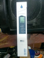
Here is a simple conductivity gauge, about $40 on amazon, that can be useful in exploring streams in AMD areas. Conductivity is just electrical resistance of water. Conductivity can be interesting info in AMD areas, because AMD inputs can release metals such as aluminum into streams, harming or even wiping out trout. AMD inputs are local inputs; one stream can be trout-free - such as buck mountain or sandy run in carbon cty (link below) - while nearby streams have low or trout-tolerable AMD and conductivity levels. Conductivity gauges are simpler and cheaper than pH gauges. Also, AMD has a more direct effect on conductivity than pH.

Good way to use the meter is to get a quick conductivity level when exploring possible AMD areas and compare to nearby streams at similar flow levels. Stream looks fishy but you don't find any trout and the conductivity is highly elevated, time to move on...

> "AMD pollution produces noticeably elevated conductivity
readings since the dissolved metals, sulfate, and hydrogen ions can all conduct a charge." "Conductivity bridges (or meters) are rugged pieces of equipment and very useful in the field as they are quick and easy to use." good source:
http://tinyurl.com/k5edufy
also
http://tinyurl.com/pcsp29t

> there are regional conductivity tendencies, so you have to compare nearby streams

> AMD discharges are more constant than rainwater inputs, so conductivity will tend to read higher at low flow (for ex summer vs spring)

> some streams with trout-lethal AMD are known and can be comparison streams. for example, in the anthracite region:
http://tinyurl.com/k4vm65a

> conductivity can also show acidity release from snowmelt affected by acid rain (see data this spring for indiantown run w/ conductivity info and apparent snowmelt spike)
http://tinyurl.com/lskoxod

> good to buy an 84 muS calibration solution for the gauge to verify its tuning and calibrate if needed. also, like everything else :), it's on amazon.

> like a lot of things, have to try it and read up a bit.
 

Attachments

  • 13926372647_d968831cac_z.jpg
    13926372647_d968831cac_z.jpg
    134.7 KB · Views: 8
Have you found a cutoff level?

In other words, above this level: no trout.

Below this level: trout can be found.

I know that there are some AMD streams that have high conductivity levels, but still have trout. I think this is because it is not just the quantity of dissolved materials that matters, but what those materials are.

Some streams have a lot of aluminum, and in that case the stream is toast. But it can have lots of iron and the conductivity levels will be high, but there can still be trout, because iron is not very toxic, while aluminum is.

That was a very amateurish stab at the topic. Maybe Mike or someone else who knows more about it can do better.

The other thing is, if it's a brookie stream, and you go there when the water temps are right, and throw a dry fly around, you will find out that the brookies are there in less than 10 minutes.
 
No fixed cutoff level of conductivity because 1) base-rate stream conductivity varies by region, and 2) it varies by flow level (higher conductivity at low flow).

good examples of conductivity variation w/ flow levels in anthracite region: Environmental Pollution, September 2007, Pages 216–226
"The impact of episodic coal mine drainage pollution on benthic macroinvertebrates in streams in the Anthracite region of Pennsylvania" A. MacCausland, M.E. McTammany


that paper: "Specific conductance fluctuated seasonally in episodic sites; it was lower in winter when discharge increased and higher in summer when discharges decreased and mine drainage made up a larger proportion of stream flow."

Electrical conductivity is not a perfect AMD indicator, but it is sometimes better than pH and the gauges are smaller, cheaper, and less fussy than pH gauges. page 11 here "AMD pollution produces noticeably elevated conductivity readings...:"
http://tinyurl.com/k5edufy

Practically speaking, if a small remote Schuylkill stream has elevated conductivity compared to other area streams, it may well be AMD. Many miles of streams with AMD, or that could have it.

In the anthracite region, a small remote stream in forested land that reads 80-100 muS conductivity at high flows seems suspect to me. Particularly if clean streams nearby are reading 20. Some streams clearly have elevated conductivity and trout, they might read 60 in high flows.

Since I fish year round and run from stream to stream, the gauge helps with a stream that isn't ideally fishable - cold and/or high flows, or maybe just low trout numbers. Don't see fish and the gauge is flying? move on instead of moving up on the stream.

Also, can sometimes grab a bit of water at the base of a mountain where a stream crosses road, see the conductivity before you hike around posted land to fish up in the SGL or state forest...
 
I did some Electro fishing while in an internship and we found trout in streams with conductivity over 150 muS. I think we may have found a stream or two over 200 muS that held wild trout. I do not think there really is a cut off level where no trout will survive. I know we have found that streams that had significantly higher conductivity compared to other streams in an area and the ones with a higher reading often did not have trout. i agree with K-bob that it can be a useful tool as long as you know what other streams in the area are reading.
 
"the ones with a higher reading often did not have trout. i agree with K-bob that it can be a useful tool as long as you know what other streams in the area are reading."

right and AMD is more likely to be an issue in areas of Schuylkill/Carbon/Luzerne that coincide with anthracite:

http://www.mininghistoryassociation.org/Meetings/Scranton/PA%20Anthracite%20Fields%20Map%20TIF%20BL01.jpg

 
did some reading, and the reason for local/regional base rate differences in stream water conductivity is the soil & geology. so elevated conductivity vs similar local streams may indicate AMD, but I dont look for some general red line level of conductivity across regions.
 
I tend to think of AMD as acid mine drainage, but mine drainage in the anthracite region is often not particularly acidic (see below). Simple, stable conductivity gauges may work better than pH meters to detect anthracite-area streams with near-neutral mine drainage.

"AMD-Abandoned Mine Drainage: Polluted water flowing from abandoned coal mines. This water is often laden with heavy metals and net acidic. No two discharges are exactly alike chemically. The water typically ranges from a pH of about 2 to 8. A pH of 7 is considered neutral. When it’s acidic (lower than 7 pH), it’s called Acid Mine Drainage. When it’s alkaline (higher than 7pH), it’s called Alkaline Mine Drainage. Metals can range from a few to thousands of parts per million (or milligrams per liter – mg/l) in solution or as a precipitated sludge. In the Anthracite Region, most of the drainage is near neutral, laden with less than 100 mg/l iron and originates from underground mines."

source:
http://epcamr.org/home/content/amd-amr-and-more-alphabet-soup/amd-abandoned-mine-drainage/
 
I dont even know where to begin with this. I understand your purpose, but you are over simplifiying something that is extremely complex. People have dedicated their entire careers to understanding the geology, chemistry and treatment of AMD. I am one of them - although I am a bit of a newbie.

Here are a couple of the many things to keep in mind when dealing with AMD:
- AMD metals are not the only ones that can drive up conductivity. Also, not all metals are equally as damaging. In most cases, Aluminum and Acidity are your 2 most damaging.
- There is no hard line for conductivity levels or metals where a stream will hold trout or not.
- The worst AMD is water that you can not visibly tell is AMD. This means that all the metals are dissolved still. As the metals precipitate, acidity is released - further driving down dissolved oxygen, alkalinity and pH. Metal precipitates coat the stream bottom and gills of fish, further damaging aquatic life.
- Sometimes, a stream will have a "dead zone" where all the metals drop out and acidity is released, where there is virtually no life in it. But it returns to a viable trout stream further downstream. Typically this will occur where the AMD is a small portion of the overall stream flow and the stream has a high buffering capacity to neutralize the acidity.

Feel free to pm me with any questions you may have.
 
Also, you can buy a small meter which will read both conductivity and pH for around 100 dollars. Hanna insturments makes the ones I use.
 
Thanks, yeah, I know amd is very complex and that I have simplified things. Not trying to develop or give a complete understanding of amd, just want a simple fast approach when looking for trout in anthracite region.

I find a basic conductivity gauge is useful to test for distinct AMD issues in anthracite mining area ... the gauge can show elevated conductivity on similar nearby streams on the same day. As I mentioned above, it's relative, not cutoff, and conductivity is not perfect, but it is useful.

For example, the other day in the anthracite region, a stream I know is dead w/ amd read 110 muS, while some streams nearby read 20 and had fish. With a 20 muS reading at a road crossing on that day, I was ready to hike around posted land to fish, but if I had seen another 100+ muS level, I might have moved on. Not complete, but Id rather have the conductivity info than not have it.

So, in that mining area having the gauge is better than not having it at least for me. Again, not trying to fully understand amd or any particular stream, just looking for a few fish :)

Have seen coated rocks, it's gnarly....
 
I get why you do conductivity readings. They are a decent indicator for AMD pollution. Guess I felt the need to add my 2 cents cause I deal with it every day.

If you like the coated rocks, check out these coordinates on a high quality aerial map program like Google Earth:
40d 24' 32.66"N 78d 39' 17.26"W
or look just north and slightly east of the intersection of Sportsman Road and Portage Street, Portage PA.

Its a vertical borehole dishcarging a couple thousand gallons per minute and has 10+ acres of land destroyed by iron precipitation. The stream adjacent to it is a clean trout stream. The discharge flows in the opposite direction then joins the stream further down and kills it.
 
thanks yeah that is pretty wild
 

Attachments

  • 13940275139_9280f270a5_m.jpg
    13940275139_9280f270a5_m.jpg
    36.9 KB · Views: 7
As usual Bob, great stuff, and kudos to PA Geo. too.
 
Another thought on gauges: conductivity can be a decent quick-and-dirty AMD pollution indicator across nearby streams, but acid rain is different. Study linked below (pages 91-93 in original page#s) gives pH & conductivity data for streams with acid rain issues. In these streams with acid rain more than amd, pH was a good predictor of trout presence and numbers, while conductivity does not look useful. pH was related to geology... so maybe look @ pH & geology not conductivity for acid rain:

http://www.bucknell.edu/Documents/Biology/BMcInerny2006AcidPrecipThesis.pdf

study above is related to this one:

http://www.ncbi.nlm.nih.gov/pubmed/18258282
 
Very interesting topic, thanks for the info. Especially relevant this week as I fished McKean county for the first time last weekend and drove past and probably fished suspect water.
 
Back
Top