Otter Creek - York County - Flood Damage

Swattie87

Swattie87

Well-known member
Joined
May 3, 2011
Messages
5,788
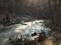
I knew it flooded pretty bad this Summer, but I had no clue how bad. There was debris in trees 20 or more vertical feet off the stream bed. Clean up efforts are underway, but there's some big stuff in there...Cars, camping trailer frames, hot water heaters. Will try to make at least one of the clean up days. Not gonna be easy work given the topography. Have no clue how they'll get some of the big stuff up and out of the lower gorge.

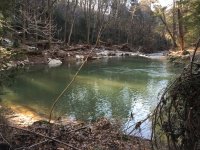
This was between Kline Rd. and the mouth. It was like a completely new stream...massive holes were formed and nothing looked the same to me since the last time I was there...April 2017. Much heavier water stretching further upstream than before. Worst small stream flood damage I ever recall seeing. Good news, three surviving wild Browns were caught and released, but most of those new massive holes appeared vacant. Anybody else been down there since the flood?

Amazing how local of an event this was. I fished a neighboring stream today too that showed no evidence of a recent flood event.


Attachments

  • 12-23-18 (9) - PAFF.jpg
    12-23-18 (9) - PAFF.jpg
    138 KB · Views: 19
  • 12-23-18 (12) - PAFF.jpg
    12-23-18 (12) - PAFF.jpg
    136.5 KB · Views: 20
  • 12-23-18 (14) - PAFF.jpg
    12-23-18 (14) - PAFF.jpg
    134.9 KB · Views: 17
  • 12-23-18 (17) - PAFF.jpg
    12-23-18 (17) - PAFF.jpg
    140.3 KB · Views: 18
I was there the day after it flooded. There were whole houses in the stream and most of the bridges over otter were gone, even the highest bridge on gumtree rd sustained massive damage. I really feel for everyone on the area.
 
How deep do you think that big pool is?

And what do you think caused the pool to form at that location? I can't see the landscape context from the photo?

Is the pool at a meander bend?


tb - I’m not sure how deep. The water was still pretty off color from rains this week. There’s a sandbar down the middle, just short of the main current channel in the picture. I suspect the deepest spot is near, or just beyond, the current swirl you see in the center of the picture.

The creek is coming out of a long straight section where the flood could pick up velocity, and then makes a 90 degree right hand bend at that location. Immediately after this corner hole it begins to significantly pick up gradient as it begins its final drop to the river. It looked to me like the water was hitting the hillside (picture left) nearly head on, and dug out the hillside before it funneled to the right and over that first drop. There always was a decent corner pool there, probably 3 or 4 feet deep, but the pool is now probably 10x the surface area it was before. It was hard to capture it in one photo. I’m sure it’s deeper than 3 or 4 feet now, but tough to say how deep.

Edit: Before the flood, I would have already said this section of creek had very good physical habitat. I’d now say it’s excellent. It’s marginal wild Trout water given its watershed size, and it’s heavily stocked, but it will be interesting to see what happens here.
 
It’s marginal wild Trout water given its watershed size, and it’s heavily stocked, but it will be interesting to see what happens here.

I always thought marginal as well because of thermal issues however I noticed that it is being considered for class A status?? I suspect This may be just in one small section I know of well above the gorge that you were fishing.
 
Swattie87 wrote:
tb - I’m not sure how deep. The water was still pretty off color from rains this week. There’s a sandbar down the middle, just short of the main current channel in the picture. I suspect the deepest spot is near, or just beyond, the current swirl you see in the center of the picture.

The creek is coming out of a long straight section where the flood could pick up velocity, and then makes a 90 degree right hand bend at that location. Immediately after this corner hole it begins to significantly pick up gradient as it begins its final drop to the river. It looked to me like the water was hitting the hillside (picture left) nearly head on, and dug out the hillside before it funneled to the right and over that first drop. There always was a decent corner pool there, probably 3 or 4 feet deep, but the pool is now probably 10x the surface area it was before. It was hard to capture it in one photo. I’m sure it’s deeper than 3 or 4 feet now, but tough to say how deep.

Edit: Before the flood, I would have already said this section of creek had very good physical habitat. I’d now say it’s excellent. It’s marginal wild Trout water given its watershed size, and it’s heavily stocked, but it will be interesting to see what happens here.

Thanks for the explanation, it makes sense. I'm very interested in the stream dynamics, pool formation type of stuff.


That auto is an urban mud sill. All that's needed to complete the scene are a few shopping carts. It's too bad to see scenes like this in urban areas or in rural parts of York Co. My understanding is that Muddy Ck took a big hit in areas as well. Cabin Ck looked to have some new or "enhanced" vertical stream banks and small tribs to the Susquehanna in the Long Level area were pretty torn up with shifting rubble and gravel substrates, vertical banks, exposed tree roots, and log jams of a size that one would not expect on a very small stream. I climbed over one that was eight feet high on a stream that is probably normally four to five feet wide from wetted edge to wetted edge. And it wasn't just logs. There was quite an assortment of human generated debris.
 
Muddy Creek watershed sustained some pretty severe damage. Personal property loss on the flood plain is evident in the trees and banks everywhere. A video was shared with me yesterday illustrating the damage to the railroad tracks that the MaPa railroad uses. This narrow gage railroad runs out of Muddy Creek Forks up to just below Laurel and is used for stocking and scenic tours run with volunteer time and donations. It’s heartbreaking to see what the old timers are up against.

With all the damage from the late August flood, it is always interesting to see what reshaping occurs along familiar reaches of stream. Mostly stable holes are dredged deeper and bedload deposited at the tailouts raising the pool elevations. Habitat improvements in disguise.

I’ll see if I can share that video.
 
FYI - in regards to Otter Creek, it sounds like the Lancaster Conservancy, who "owns" some of the land, will be working to clean up some of that debris.
 
Maurice wrote:

With all the damage from the late August flood, it is always interesting to see what reshaping occurs along familiar reaches of stream. Mostly stable holes are dredged deeper and bedload deposited at the tailouts raising the pool elevations. Habitat improvements in disguise.

I’ll see if I can share that video.

"bedload deposited at the tailouts raising the pool elevations."

That's an excellent observation!

I'd love to see the video.
 
For those interested in helping clean up -

https://www.eventbrite.com/e/otter-creek-volunteer-work-day-tickets-53553735665?fbclid=IwAR0vwjc4uvVzQAlnUwB3X0wAERjdviRVUgKstGQ0Mb_YFrqp76s87NHbkW8

https://www.eventbrite.com/e/otter-creek-volunteer-work-day-tickets-53558851968?fbclid=IwAR26fkwuwif0yMfjrxZVJzzO4wRbkvWePB8X9Gp2NmtOIlusfHsUhr1weKU
 
I helped today by volunteering in the morning. It rained the whole time but the dozen or so volunteers never complained or tapped out. We carried out enough debris to fill a tandem sized dump truck. The method was to “bucket brigade” large piles of debris that had been collected on previous dates. There was wood, metal and plastic. (Mainly vinyl siding) the trail was rugged and challenging with the rain. When finished we were all soaked to the bone.

It was a very enjoyable and rewarding experience. 2.5 hours of a rugged work out. But never more than you could handle.

There is still a tremendous amount still down there. Many hands make light work. If you wish to help on a future clean up, see the links above in Raftmans post.

 
Thanks for the efforts today Mo. Not a fun day to be outside probably, but a good deed done for sure. Was hoping to make today, but the brass from our regional office was in town for meetings. No chance of getting a day off today.

Saw they added a Saturday (3/23) date to the schedule. Just signed my fiancé and I up for that one. Might have my ex-FIL in tow too.

 
Back
Top