NWPA Stream Levels

Prospector

Prospector

Well-known member
Joined
Jul 7, 2015
Messages
1,034
Location
Butler Co home, Forest Co camp
It's no secret that streams are low, but I thought I would share some photos I took over the weekend. I headed to camp in Forest Co to do some work and snuck out for an hour to check a stream for trout. I purposely chose a stream where I was not sure if it had any wild trout. I would fish until I caught a trout and then consider the mission a success and immediately quit. This was not a pleasure trip but instead an information gathering trip.

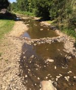
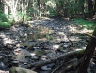
I crossed East Hickory Creek and it was so low I snapped a photo off the RT 666 bridge looking upstream (see photo). I got to the trib I wanted to fish. Water temp came back at 60 degrees but the flow was terrible (see photo). I decided to stick with my plan due to the water temp but it was really difficult to find a hole. Many areas, like in the photo, were virtually impossible for fish to travel from a shrinking pool to a pool that offered some protection.

The end result was I landed five 4 inch minnows and a shiner. No sign of a trout. The flow was so slow it was difficult to find a surface bubble. Is it safe to assume that the lack of dissolved oxygen could have killed trout that had been in this stream in May? Do large minnows and shiners require less dissolved oxygen than trout, thus allowing them to carry on when trout cannot? The water temperature itself was no problem at all.

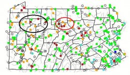
I also attached a photo of the USGS stream flow conditions from today. The area I circled in BLACK is the general area where these streams reside and all small streams are dangerously low. The 2 green dots in that circle are from gauges on the Allegheny River, which of course is water released from a dam. All other streams are a trickle. I also circled the streams RED in Potter/Clinton Co stretching from the First Fork to Kettle to Young Womans Creek. I'm concerned about the small tribs in that area too if my "lack of dissolved oxygen" theory is a real and valid concern.

Any thoughts from those of you with a much better knowledge of the science behind cold temp, low flows and dissolved oxygen?

I don't know the science so my only measuring stick for this was in June 10 2016 when I caught 53 Brook trout and 7 browns from a trib to Kettle (all small wild fish). The next year on June 9th I fished the same stretch of that same trib and caught 14 brook and 10 browns. What happened after my nice catch? A drought and high temps ensued throughout the summer to the point that on Aug 27 2016 the cfs fell to 12. Today Aug 25 2020 the Kettle cfs is 10 (25th percentile is 13). The all time low on this date was 1971 when it hit 2.9. I can't even fathom that.

Thanks for your thoughts!!
 

Attachments

  • East Hickory Creek Aug 22 2020.jpg
    East Hickory Creek Aug 22 2020.jpg
    148.8 KB · Views: 9
  • E Hickory Trib Aug 2020.jpg
    E Hickory Trib Aug 2020.jpg
    117 KB · Views: 5
  • USGS Streamflow 8-25-20.jpg
    USGS Streamflow 8-25-20.jpg
    148.6 KB · Views: 6
Thanks for the report on that area. Hopefully, we get some rain from these tropical systems and can get into a Fall weather pattern sooner rather than later.

Droughts are bad news for Trout, no doubt, but things aren’t always as bad as it seems. I was in the Kettle Creek drainage in September 2016, at about the minimum point of the flows during that spell. About a week before the rains that Fall picked up maybe. The flows, according to the gauges, were lower than they are now. Kettle at Oleona was very skinny, but flowing continuously. Little Kettle and other similar sized tribs were still mostly flowing continuously, but there were some spots where the flow was below the substrate. The water temps were in the high 50’s, and the fish were stacked up in the pools, but there were plenty still alive. A week or two after I was up, it rained a bunch and some guys got together up there for a mini-jam and reported decent fishing as I recall. The fish figure it out. Not unreasonable to think there may be a negative short term impact to populations, but all in the normal swing of things. Wild Trout are good at making more wild Trout and if there’s a temporary void in the population a higher percentage of successive years recruitment classes will survive to fill that void up to the carrying capacity. The gauges indicate the streams have been as low or lower than they are now many times. The cool water temps you found, despite the relative heat and low flows suggest there’s enough DO for the Trout, provided they got to a refuge pool.

Still, hoping for some rain.

Thread with some pics I took from NC PA in September 2016:

September 2016
 
Young Womans Creek droppped below 2 cfs and Kettle Creek at Cross Fork dropped below 9 cfs.

From what I've seen from droughts in the past, flows that low cause a pretty significant drop in wild trout populations in the NC PA freestoners.

Both severe droughts and extreme scouring flood flows knock wild trout populations down in the freestoners.

The PFBC has surveyed some streams regularly over a pretty long period. The populations in those streams bounce around a great deal. The peaks are about twice the lows.

Or, flipped around, the lows (caused by severe droughts and scouring floods) are about half the highs.
 
I traveled through NCPA on the way to the adirondacks a few weeks ago, Kettle was a trickle, pine was a trickle, lots of brookie streams were less than a trickle, pretty much just rocks.
It's bad. I was planning on a northern pa 10 day trip later this fall, if things don't change soon, looks like WV, or even the driftless area of iowa and wisconsin. (an area I always wanted to explore)
FWIW, Lots of water in the Adirondacks, but I wasn't fishing, just riding.
 
Swattie, you're right. 2016 was the worst. I remember your post from then as well. Wild trout pulled through and survived that year. That is also the year that I started a thread about local stream temps in the extreme heat and drought.

I don't worry about it now. The fish will figure it out or they won't, but me worrying doesn't do a thing.
 
jifigz wrote:
Swattie, you're right. 2016 was the worst. I remember your post from then as well. Wild trout pulled through and survived that year. That is also the year that I started a thread about local stream temps in the extreme heat and drought.

I don't worry about it now. The fish will figure it out or they won't, but me worrying doesn't do a thing.

Yeah. I don't doubt that populations in the areas with prolonged "red dot" periods on the USGS maps this Summer will likely be down for the next year or two. They seemed to be down in 2017 was my recollection, but I had great small stream wild Trout fishing in both 2018 and 2019 (years with good Summer flows) on some of those same streams. Summer 2020 started out very good too, until about the beginning of July, which coincides with when the rain shut off for most of the state (other than the eastern quarter or so).

Planning on checking out one of my favorites up your way to see how it's doing at some point here before the spawn. I'm sure it's low, but it has the habitat to allow fish to survive.
 
Had some hope that we would get some moisture from HUrricane Laura, but the latest track has it going south, through WV. Guess we shall see. Hopefully it throws some rains up this way.
 
Food for thought (for the wild trout conservation minded): It may not matter this year if the water levels bounce back due to the (hopefully) coming tropical depression or other rain. The damage to wild trout populations is likely done due to predation. Consider this: Predator populations increase as prey populations increase. So, there are likely more trout predators this summer compared with 2017.

It will take a year or two of normal+ water levels to bring depressed populations back up. Maybe it's best to leave those affected wild trout streams alone for a good while to allow them to recover.
 
Fly-Swatter wrote:
Food for thought (for the wild trout conservation minded): It may not matter this year if the water levels bounce back due to the (hopefully) coming tropical depression or other rain. The damage to wild trout populations is likely done due to predation. Consider this: Predator populations increase as prey populations increase. So, there are likely more trout predators this summer compared with 2017.

It will take a year or two of normal+ water levels to bring depressed populations back up. Maybe it's best to leave those affected wild trout streams alone for a good while to allow them to recover.

I agree with everything you've said.
 
BradFromPotter wrote:
Pine Creek in Gaines is the lowest I've seen it in over 30 years! You could almost get across it without even getting your feet wet!

Not trying to be combative or disagreeable, but statistically, it was flowing at about half of what it is now during the late Summer period of 2016. (It's at roughly 50 CFS now, and bottomed out a couple times at 25 CFS, or just below even, in 2016.)

Same thing with Kettle. Roughly 10 CFS now. It bottomed out around 4 CFS in late Summer 2016. Crazy to think. Kettle fishes best around 300 CFS or so...or with 75x more water in it.

Don't get me wrong, it's bad up there, but it's been worse. Even in relatively recent memory. We need some rain, but all will likely be ok.
 
A couple things. I sort of unintentionally mixed subjects in my original post.

1) Using my anecdotal data. That stream in Potter that had a 74% drop in brook trout after the 2016 drought year while the brown trout population stayed roughly the same. The brook trout have not recovered to their 5:1 ratio. This year it was 1.65 browns per brook. So I did not intend to imply that the stream was devoid of trout but an abrupt redistribution has occurred that may never change. I’m confident that wild populations will rebound in times of favorable conditions.

2) The stream in Forest county that slowed to a trickle that got me thinking about dissolved oxygen. That stream could have any number of reasons it holds shiners and minnows and not trout. I have always attributed the presence of fish but no wild trout to the stream being too warm at some point during the year but that is not the case in this stream. There must be other water quality issues. I did catch wild trout there 40 years ago.

3) I agree with FlySwatter that predation is a factor. I pay close attention to streamside tracks. On the trib to East Hickory I fished Saturday it does have many sandy or muddy areas to observe this.
 
Swattie87 wrote:
BradFromPotter wrote:
Pine Creek in Gaines is the lowest I've seen it in over 30 years! You could almost get across it without even getting your feet wet!

Not trying to be combative or disagreeable, but statistically, it was flowing at about half of what it is now during the late Summer period of 2016. (It's at roughly 50 CFS now, and bottomed out a couple times at 25 CFS, or just below even, in 2016.)

Same thing with Kettle. Roughly 10 CFS now. It bottomed out around 4 CFS in late Summer 2016. Crazy to think. Kettle fishes best around 300 CFS or so...or with 75x more water in it.

Don't get me wrong, it's bad up there, but it's been worse. Even in relatively recent memory. We need some rain, but all will likely be ok.

where is the 50cfs being measured?
 
BradFromPotter wrote:
where is the 50cfs being measured?

Pine only has one gauge on the USGS site. Roughly Cedar Run I think. That's what I'm comparing apples to apples from 2016 to 2020 from.

I suppose, certain parts of the watershed could be contributing to those flows differently in 2016 than 2020, given its size. But, from Cedar Run upstream anyway, as a whole, it's flowing roughly double what it was in 2016 at this time. Same with Kettle (at Cross Fork). (Both of those flows are VERY low however. Just wanted to report the numbers.)
 
Swattie87 wrote:
BradFromPotter wrote:
where is the 50cfs being measured?

Pine only has one gauge on the USGS site. Roughly Cedar Run I think. That's what I'm comparing apples to apples from 2016 to 2020 from.

I suppose, certain parts of the watershed could be contributing to those flows differently in 2016 than 2020, given its size. But, from Cedar Run upstream anyway, as a whole, it's flowing roughly double what it was in 2016 at this time. Same with Kettle (at Cross Fork). (Both of those flows are VERY low however. Just wanted to report the numbers.)

Good observation ^

While things look dire in central and western PA, if we get some decent rainfall soon, the short duration of the low flows will not have a major effect on the trout population up there as has happened in other years.

Now come on rain!!
 
Swattie87 wrote:
BradFromPotter wrote:
where is the 50cfs being measured?

Pine only has one gauge on the USGS site. Roughly Cedar Run I think. That's what I'm comparing apples to apples from 2016 to 2020 from.

I suppose, certain parts of the watershed could be contributing to those flows differently in 2016 than 2020, given its size. But, from Cedar Run upstream anyway, as a whole, it's flowing roughly double what it was in 2016 at this time. Same with Kettle (at Cross Fork). (Both of those flows are VERY low however. Just wanted to report the numbers.)

Like I said Pine in Gaines is the lowest I have ever seen it in over 30 years. Comparing Cedar Run to Gaines is comparing apples to oranges. I understand at Cedar Run it is not as low as 2016. The West Branch of Pine & upper Pine are also at the lowest I've seen them flow in the same time period. We are just about in a stage 3 drought here in Galeton. That has never happened since moving here in 1995.
 
BradFromPotter wrote:
Like I said Pine in Gaines is the lowest I have ever seen it in over 30 years. Comparing Cedar Run to Gaines is comparing apples to oranges. I understand at Cedar Run it is not as low as 2016. The West Branch of Pine & upper Pine are also at the lowest I've seen them flow in the same time period. We are just about in a stage 3 drought here in Galeton. That has never happened since moving here in 1995.

Very possible. I'll trust your local knowledge on what's happening in individual, smaller parts of the watershed. I haven't been up there since late June. Things were low-ish then, but not like now.

I was using the Cedar Run gauge (and CF gauge on Kettle) since they're the only ones that can give an actual data based comparison. Clearly, there's more water in them at those points in the watershed than in 2016, though where that water is specifically coming from may be different. Agree.
 
To add something to the OP's DO question - the ability of water to hold DO is in relation to the temperature. The warmer the water, the less DO it can hold; conversely, the colder the water, the more DO it can hold. Other factors can influence DO; for instance, on two streams with the same flow, but different temperatures, you may end up with more DO in the warmer stream if it is a high gradient stream, where the water is tumbling into little plunge pools. But if they were the same gradient stream, with little mixing from the air, the colder stream would carry more DO than the warmer stream. Many folks assume that warm water kills trout, but it's the fact that warm water carries less DO that actually kills the trout.

Trout definitely have a much higher requirement for DO than fish like minnows. Minnows can go as low as 1-2ppm. Trout probably will be dead if levels are below 6ppm for any period of time. The trout have likely migrated to a cool water seep somewhere if you're only catching minnows, or they floated downstream to be a coon meal awhile ago.
 
salmonoid wrote:
To add something to the OP's DO question - the ability of water to hold DO is in relation to the temperature. The warmer the water, the less DO it can hold; conversely, the colder the water, the more DO it can hold. Other factors can influence DO; for instance, on two streams with the same flow, but different temperatures, you may end up with more DO in the warmer stream if it is a high gradient stream, where the water is tumbling into little plunge pools. But if they were the same gradient stream, with little mixing from the air, the colder stream would carry more DO than the warmer stream. Many folks assume that warm water kills trout, but it's the fact that warm water carries less DO that actually kills the trout.

Trout definitely have a much higher requirement for DO than fish like minnows. Minnows can go as low as 1-2ppm. Trout probably will be dead if levels are below 6ppm for any period of time. The trout have likely migrated to a cool water seep somewhere if you're only catching minnows, or they floated downstream to be a coon meal awhile ago.
You made a super important distinction.

[color=003366]“Many folks assume that warm water kills trout, but it's the fact that warm water carries less DO that actually kills the trout.”[/color]

This is interesting considering what I wrote in my Stream Report that covered a full week near the Kettle drainage. On June 6 I fished the Francis Branch of Slate run for the first time. I just found a place to park and started fishing. Had no idea if it was a good location. Knowing the reputation of the overall watershed I expected this stream to be loaded with trout. Water temp was 60 degrees (same temp as the stream I fished on Saturday). I worked my way upstream quite a ways before I had my first take. In that location I caught 3. I reflected on what the difference was. Only obvious thing was this area had quite a bit more drop than the lower flatter section where I started. The incoming riffle was very oxygen rich. I tucked that away and found those types of areas continued to produce the trout. I only caught 7. Without really knowing if there was any substance to this statement, I added it to my report since it was what I observed ....”At first there were no fish for a long way. Was either related to shale bottom with no holding cover or it was related to not enough drop in elevation to keep the oxygen up.”

I have begun to notice that brook trout seem to favor locations that are well oxygenated over flatter pools
 
Looking like we're all gonna get a good soaking by saturday - along with cooler temps
Let's hope so
 
Back
Top