Main stem Delaware flow

wbranch

wbranch

Well-known member
Joined
May 26, 2009
Messages
2,239
Location
York
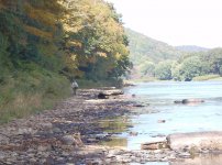
I happened to look at the flows on the WB and main stem this morning as I was thinking of going up for a few days. I was shocked to see the flow at Lordville was just 432 cfs. In the fifty years I have fished the main stem I do not remember it ever being so low. At that level untold thousands of nymphs will die and the trout will be easy targets for the eagles, ospreys, and numerous stripers.

Most recent instantaneous value: 432 10-07-2016 03:45 EST


Yeah, I saw just that Matt.

It's hard to believe they would pull the plug to a point where the riverbed is actually exposed in areas. Up and down yo yo releases this year have been crazy.

Stilesville
 
When we left Buckingham on Wednesday it was much lower than anything I've seen in 25 years. I thought we'd turned the corner on this stuff.
 
Thank God it hasn't been in the 90's like it was pretty much all summer. Still when you expose 50% of the river bed you are killing tons, literally, of aquatic insects. Remember many of the mayflies we depend upon for great hatches emerge from the shallower riffle sections of the river. It will be interesting to see how this draw down affects the Henricksons and Blue Quills next April.

There was a period from March 2016 to May 2016 when the Stilesville gage was running around 125 cfs and yet the fishing in that area was quite good this season.
 
Matt,

I may be worse than you think. Lots of exposed riverbed, nymphs and caddis. See pics from Wednesday.
 

Attachments

  • looking up from stockport access.JPG
    looking up from stockport access.JPG
    208 KB · Views: 2
  • Stockport below eel weir.JPG
    Stockport below eel weir.JPG
    135.5 KB · Views: 4
  • Exposed caddis.JPG
    Exposed caddis.JPG
    216.7 KB · Views: 5
  • Cemetary pool.JPG
    Cemetary pool.JPG
    195.4 KB · Views: 3
  • Cemetary pool 2.JPG
    Cemetary pool 2.JPG
    183.4 KB · Views: 3
New York City water authority does what ever it wants with the river. If you don't like it; Shove off.

Shouldn't the EPA step in here?
 
Isn't the main stem a National Park? Park Rangers stoped us below Buckingham in the spring. Wonder if it could fall to the Feds to help.

What NY is doing is BS. I understand they yo-yo the flows all year...but this level is ridiculous.

In that Stockport Access photo...we had 2 boats floating in that exact spot the day before.
 
It has some designation but it's not a national park. This is just a fact of life up there. This is an extreme. Years ago we went into hurricaine season with the reservoir in the 90% and when Ivan hit we lost a trailer at the old DRC campground. I think a life was lost because there was no room in the reservoir for the rain. I don't think the Feds have a say in this.


it's New York city, not New York who control the reservoirs. And I agree.
 
The West Branch was up one day and down the next during our trip, but I guess we were fortunate it was not worse the last week of September. This crazy up and down pulsing of the flows can't be good for the pre-spawn fish or the river ecology. There was little to nothing happening on the Main Stem and it seemed that most fish were taking refuge in the West. Now the West is way down.
 
Get used to it. They have an extension on the hydro electric project. I'm guessing this be the norm in the next 5 yrs.
 
Not again!
I thought that maybe the DEP had learned their lesson during the Cannonsville Dam fiasco last year. I know they have the small lake Wallenpaupack hydro water source to supplement the main stem levels, but what is next.
 
It really is a disgrace. No warning, no reason or explanation. The public is really the only way to get answers out of the DEP. For you Upper Delaware fisherman, contact the following.
Paul Rush (NYCDEP) prush@dep.nyc.gov ph:845-334-7107

Thom Murphy (NYCDEP) tmurphy@dep.nyc.gov ph: 914-742-2006

Mark Klotz (NYSDEC) maklotz@gw.dec.state.ny.us ph:518-402-8233

Fred Hensen (NYSDEC) fghenson@gw.dec.state.ny.us ph: 518-402-8901

Mark Hartle (PAFBC) mhartle@pa.gov ph: 814-359-5133
 
Coversely on June 28, 2006 there had been sustained rain in the Western Catskills for several days. The reservoir was close to being full. The reservoir authority could of opened the gates and let out thousands of cfs to release some of the impending water.

At the maximum flow 43,400 cfs was rushing by, and through, my cabin. The structure wasn't damaged but the high water mark on the door was 36" above grade.

The flow at the Lordville gage was an astounding 126,000 cfs! Today it is 425 cfs.
 
Andy,

Is picture #4 at Stockport looking down towards Cemetary? Wow! the cased caddis have really taken a hit.

How is it that the Port Jervis gage is running close to it's historical average for the date? I looked at the chart for the last five days and it is having huge up and down swings every day. From around 900/1000 cfs all the way up to 2300 cfs. I don't know if there is a problem with the gage or is there a huge pulse of water coming in every 24 hours.

http://137.227.252.11/nwisweb/data/img/USGS.01434000.107372.00060..20161003.20161010.log.0.p50.gif
 
Jeff White out or the DRC emailed me to say the reason Port Jervis is at normal flows for this time of the year is because Lake Wallenpaupeck is being drawn down 5+ feet so work can be performed on the dam and property owners can work on their boat docks. Jeff told me they do this every five years.

If many of you aren't aware there is a huge portal up on a hill right next to the Lackawaxen. They just open the portal and 2500 cfs come pouring out. If you look at the Port Jervis gage on the USGS you will see widely separated lows and highs. Jeff told me it is because the water is not coming out at that high volume 24 hours a day.
 
Last I read, the process at Wallenpaupack will take about 4 weeks. Without significant rain, nothing's going to change in the near future. No rain on horizon, low water in Cannonsville and refusal to let any additional out of Pepacton = no change to current dismal situation. Ironically, FUDR has the "Water, water everywhere" event coming up. Should change the name to "Outta water everywhere".

When up recently, I did speak to two locals that have an opinion on why the yo yo releases have been more prevalent. They believe that FUDR's approach to getting water is the problem. When dealing with the city and the dam, they raise their voices, talk down to the "powers that be", yell, argue and belittle. The locals feel it's being done to mess with guides and p*ss off the FUDR. I hope that isn't the case. If it is the case, FUDR better change their approach before the city wrecks the fishery.
 
Well, dont look now but they just dropped the Lehigh to an unimaginable 91 cfs at FEW. 91!! That's gotta look like a dry river bed. I'm hoping it's just a momentary screw up cause I've never seen anything like that there.
 
I've long opined that the Lehigh cannot be safely crossed on foot in the Gorge at any flow...175 cfs and just over knee deep was lifting me off my feet. Might just be doable at 91 though.
 
I've seen the Lehigh at 91 cfs at FEW before. Was around this time a few years ago.
 
Back
Top