troutbert wrote:
k-bob wrote:
As TB notes, the original linked article mentions how channeling may affect flood impacts on streams. Spend some time w "PA MAP 3.2 ft" lidar map at pasda, and many small and remote streams appear channeled and separated from larger floodplains... ex is little nescopeck east of nescopeck state park, but not unusual in PA. Channeling may be common but not sure it can be redressed now?
There are ways to redress channelization.
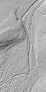
For example on Fields Run.
N 41.20451 W 77.95083
You can paste the lat/lons into AcmeMapper and look at the topo map.
The water quality of this stream is good and the watershed is nearly 100% forest and it's on state forest land.
But the trout population is low. The reason for that is poor physical habitat.
And the reason for that is the stream appears to be channelized and straightened and confined to one side of the floodplain and separated from the rest of the floodplain by an old road grade, which may have been a logging railroad grade back in the day.
Solution: Eliminate the old road grade by regrading. Plant trees on the exposed soil.
Once things are well re-vegetated, in 10 years or so, come back and do large woody debris additions.
The large woody debris will start to create pools and cover, provide grade control to reverse incision, create lateral movement increasing sinuosity, and development of multiple channels, all of which would lead to the stream being re-integrated with its entire floodplain.