T
topher465
New member
Sorry if this has been covered, but the details of what is closed and not is a little murky, at least to me.
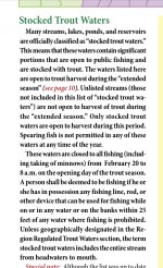
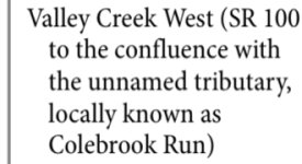
The PFBC pamphlet states that waters are closed from the headwaters to the mouth unless geographically noted. Most of the waters I see have notes where the trout are stocked, both the upstream and downstream points. I’d assume the whole stream would be closed, but the geographical note adds a bit of confusion. Also, does that include all the tributaries? Anyone who might have some insight, that would be appreciated.
The PFBC pamphlet states that waters are closed from the headwaters to the mouth unless geographically noted. Most of the waters I see have notes where the trout are stocked, both the upstream and downstream points. I’d assume the whole stream would be closed, but the geographical note adds a bit of confusion. Also, does that include all the tributaries? Anyone who might have some insight, that would be appreciated.