Carbon Co. Wilderness Stream

F

Fishbum

New member
Joined
Jul 16, 2015
Messages
4
Hello everybody, I am new to the forum and I am enjoying my last summer in Pennsylvania. Since I will be moving out of state at the end of the year I have been enjoying as many different bodies of water I can this summer. I have been wanting to try a few wilderness streams in the Jim Thorpe area; I was wondering if anyone would be interested in joining me. The stream is bear creek inside the gorge, if that stream is not worth fishing you can PM and I would be more than happy to fish somewhere else. Thank you.
 
If there are not any private property issues the only way I see possible on the maps is either hiking down through little bear creek or along bear creek. Since the lehigh is not the best river too cross.
 
Just be aware that much of the land at the top is private. I'd wait until the river goes down enough to cross. Good luck, and be careful up in there.
 
Its all posted at the top and in a "private" patrolled neighborhood. I was just poking around there today.
 
I've researched and scouted this one too, but never fished it. I believe the only legal way (without direct private landowner permission) to access the stream is from the public land at the mouth, which would likely involve a crossing of the Lehigh. As mentioned, the headwaters of both branches are in private communities completely posted against non community land owner trespassing.

Par for the course when it comes to streams on private land in the Poconos.
 
I've poked around there also trying to fish the trib called little bear... sometimes the Poconos are the PostedNos :)
 
I was with Swattie once while trying to figure out how to get on it. The top area isn't just posted, but if there were a scale of postedness, this ranks right up there with the red lines and "deadly force authorized" signs found at military bases and national labs.

Anywhere outside the park, you cannot fish, pass through, etc. The very bottom stretch is in the park and open to the public, but again, the bike trail and tracks are on the far side of the river. So your choices are to cross, or find your way down (and then back up) a large, rocky, VERY steep hill from Mountain View Dr.

A raft seems to be the only viable method.
 
when I started fishing, I decided to just hike right down into a carbon county trout ravine, not studying maps or listening to a local guy who told me how steep it was... made it in and out, but after ledges, snake habitat, rhodo crawls, and profuse sweating, a map fan and planner was born. have seen bears rattlers coyotes on carbon Lehigh tribs, scenes out of yul brenner spaghetti westerns:) I still fish around there, leaving precise as possible plans of where i am going..but the walk into bear creek looks far too hairy for me, and I am not sure you can do it w no posting. carbon county is a wild place for only 90 or whatever miles from philly.
 
Bear creek is doable. As mentioned above there is access from mountain view dr. Very steep is an understatement for the road that leads down to the river. I used to park at the top of the road and hike into the stream and back out through the road. It's not an easy trip by any stretch of the imagination.
 
Thanks for all of the information everyone. I'll probably poke my nose around there next week and play on the conservative side when hiking.
 
I'm iffy on the legal access via Mountain View Dr. theory. I was never comfortable doing it that way from a posting perspective, not necessarily the hike down in. I recall there is a typical Poconos "No Trespassing - Owners and Guests Only" or something similar sign at the entrance to the development further out on Bear Creek Dr., before it turns into Mountain View.

It's on my list to try, but for me it will involve figuring a way to access it from the mouth via the public land to the west. I think to access it from any other direction without landowner permission will involve trespassing in some form.
 
Yeah, that area where you'd park on Mountain View is in the park. But I don't know whether the road itself is a private road or not. Either case, if you did try that, based on the topo that hill does NOT look like something to mess with. For what ultimately amounts to a rather short stretch in the park? No thanks.

If Swattie procures a raft and is willing to take me down the river to get there, hey, I'm game. Otherwise this one just remains a pretty looking line on a map.
 
Yep, a lot of that land to the north of the stream is public land…Lehigh Gorge SP or SGL 141, but to get to the part close to the stream, you’d have to access it via private (and posted) land along Bear Creek Rd. I suppose you could do a lengthy 3 mile-ish hike from the last parking lot showing further north on the SGL map…and that’s just to get to the top of the ravine on public land…then you’d still have to find a way down.

I’ve procured said raft. Just looking for a couple nuts to do it with me! My plan would probably involve biking up from Glen Onoko and finding a relatively calm, slow, pool section of the Lehigh. From research, I think there is one just upstream of Bear. Ditch the bikes, and find a way down from the rail trail to the Lehigh. Inflate the raft with a battery powered pump and attempt to cross the Lehigh at a 90 degree angle as much as possible. Ditch the raft, hike to the mouth of Bear and fish. Repeat in the opposite direction on the way back. In order to justify doing this, you probably want flows to be good on Bear…this of course makes the Lehigh harder to cross.

I’m doing a whitewater trip on the Lehigh with some college buds next month. I’ll assess the feasibility of this plan while on that trip.
 
There are much easier places to get lost on the Lehigh tribs, there are several nice runs further up in Hickory Run SP with infinitely easier hikes to water. That being said, I have tried to fished Little Bear to Bear and the hike was brutal and I'm known to be part billygoat. I have have fished up from the river and the hike was no easier, the gradient was ridiculous just to get to some semblance of a plateau. You can bike from Glen Onoko and cross when the flows at the dam are < 300 cfs, check the USGS site before you go. If you're not used to this you might want to try Hickory Run, there are snakes, bears,and my buddy got stung a bit last time crawling through the rhodos, be aware.
 
I tried the raft caper and I would not advise it, unless you don't mind swimming in the Lehigh River. I got away with it twice until the third time, I clipped a submerged branch in the middle on my way back, which rendered my raft useless and I lost my rod! I needed both hands free to paddle my lifeless raft. Having a life jacket on (a must!) enabled me to get back safely.

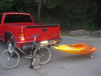
This takes a good bit more effort, but this is how I deal with the situation these days. I've posted this pic before. Just for the record, Bear is a beautiful stream with what I would consider decent WT fishing, but I think many wouldn't consider it worthwhile for everything that's involved in getting there.
 

Attachments

  • IMG_1042 (Custom).JPG
    IMG_1042 (Custom).JPG
    33.2 KB · Views: 19
great thread. but I think I've taken enough chances in that geographic area already, so bear might be too much of a bear.

I like remote areas, but IMHO just getting way out there is no guarantee of great fishing... generally speaking, getting way out there will only get you fishing as good as the habitat and geology way out there allow. thinking about that reminds me of this great little brookie stream near and paralell to a divided highway!
 
There is a lot of great information! I am pretty indecisive on this one after reading what everyone has to say. I want to fish it just to say I did, but there's a high probability it could be a rough day lol. This stream is probably going on the backburner until the water levels go down on the Lehigh. Isn't it pretty amazing that there are still streams so difficult to access? Even if the upper end wasn't posted it looks like a rough hike down.
 
"Even if the upper end wasn't posted it looks like a rough hike down."

looks like 650 ft descent at a 23% grade. pretty crazy.
 
And to think that up until about 5 years ago it was the Approved Trout water list and STOCKED!!! haha I have no idea on earth how that was possible but at one time you could drive a long long while down towards the river and into the SGL. The gate and posted signs went up about 6-7 years ago I recall. Access was always horrible though so I have no clue how it was stocked. helicopter haha.
 
Back
Top