Bowmans and Mehoopany Question/Observation

Swattie87

Swattie87

Well-known member
Joined
May 3, 2011
Messages
5,770
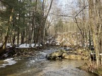
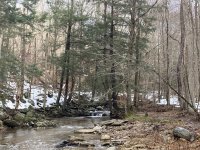
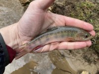
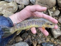
I made two trips up this Winter to explore some tributaries in these watersheds for wild Trout...And to stop for Old Forge pizza on the way home. I found a nice one with both Brookies and Browns in the Bowmans watershed, but largely struck out (one Brookie) in the Mehoopany watershed.

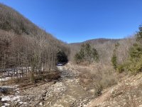
Question...Both trips flows were relatively high, but nothing blown out or anything, yet both Bowmans and Mehoopany main stems were completely Ovaltine chocolate milk. I would have expected them off color probably, but not a muddy mess. There’s clear evidence still of the flood damage on them, but how long does it take for them to clear after a rain/snowmelt event? Do they ever run clear? Or is there THAT much sediment still being processed from the floods? Were they like this before the floods?

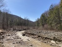
Bowmans did start to clear some as you went upstream I noticed, but Mehoopany didn’t, at least as far up as the furthest trib we tried to fish...which was also chocolate milk. I hardly ever see small tribs like that chocolate milk, but there were huge sediment bars and hillsides eroding into the stream still.
 
Those watersheds along with several others nearby that are in the gladiator region have been pounded with floods since 2011. There are lots of stretches with substantial slope failures that contribute a lot of sediment. I can attest that they do clear up and get gin clear in summer flow conditions like many of the adjacent Freestone. I have meant to explore some of the tribs there but have not gotten there to fish much. I will say that some of the nearby tribs that I have fished in the winter, I have not had much success. In the summer on the same streams it's not uncommon for 50 fish days. I think the low buffering capacity and the cold water temps can make some of those streams very challenging to fish in the winter.
 
I agree that what you are seeing is probably still the streams "processing" sediment from the September 2011 floods.

The year after the floods I fished a tributary to Mehoopany Creek that had landslides. Landslides are not very common in PA.

In the past I've gone out to look at streams after major floods, such as the Jan. 1999 flood. After those floods I saw a lot of extreme scour, including widening of streams, ripping out of gravel bars, and some channel avulsions (channel jumping). But, this was basically re-working of the floodplain sediments, eroding in some places and deposition in other places. I didn't see landslides.

A landslide is a "whole nuther thing." The side of the mountain lets go, and all the trees, soil, and rocks slide into the valley, including the stream.

So it's no longer re-working of alluvial (floodplain) materials. It's an ADDITION of massive amounts of material. Materials that were colluvial (hillslope) materials have now been added to the alluvial (stream/floodplain) system.

I think that will increase the sediment supply in those streams for a long time to come.

Around that time, I also saw landslides on a tributary to Loyalsock Creek.

I don't know if there were landslides in the upper Bowman Creek watershed. But it's nearby.

There was also a dam removal not too long ago at what had been Mountain Springs Lake, on the headwaters of Bowman Creek. That may be adding to the sediment supply.


Troutbert, there are significant landslides from these floods in the upper Lycoming creek watershed, in numerous loyalsock tributaries, Muncy Creek, upper fishing creek, Mehoopany creek, South branch Towanda creek etc. These all have a lot of glacial deposits and alot of gravel and cobble on the hills lopes in some areas.

Some good examples are behind the Hillsgrove maintenance building on Dry Run, behind the pheasant farm on Plunketts creek. There is a big project on the books for Plunketts creek to remove an old floodplain berm installed by PGC to all more floodplain access. There are plans for stabilizing the toe and catching the slope failure on the day bank as well.

As others have stated it will likely take decades for some of these places to stabilize.
 
Correction. In post #3 I mentioned a flood in January 1999. It was January 1996.

Just to keep the record straight!
 
Good discussion, thanks guys.

tb - I suspect we were on the same Mehoopany trib. I’ll send you a PM. While the main stem of Mehoopany was chocolate milk, all of the small Mehoopany tribs were running clear, except for this one.

All of Bowmans tribs were clear that I saw too, including the one I fished, and that fished well, for Winter conditions - Caught about a dozen, mostly Brookies, one decent small stream Brown.

Structurally, the flood damage on the Loyalsock tribs looks similar, but I’ve routinely had good fishing on them since the flood events. Different mix of factors though. Loyalsock watershed has better geologic features than Bowmans, and much better than Mehoopany.

afish - I remember those pictures. Had never fished up that way before so didn’t have the context at the time. While the roads are rebuilt there is plenty of evidence left otherwise.
 
When I first fished upper Bowmans Creek, in the State Gamelands, there was no stocking being done up there.

Bowmans Creek there held fair numbers of native brook trout, and it was interesting fishing for them on such a large stream.

The reason no one stocking trout up there is because it's quite infertile. Native brookies could survive it, but hatchery trout have a tough time.

Then limestone chips were added to some of the tributaries to improve the fertility.

Then some group (not the PFBC) began stocking hatchery trout in upper Bowmans, in the SGLs.

Then fishing there still produced some native brookies, but they were out-numbered by the stocked trout.

It's sad that our native brook trout get so little consideration. I haven't fished there in recent years, so don't know if the SGL section is still getting stocked.
 
Some pictures.

First four (dated 01/02/21) are the Bowmans trib. Note the clear water, and not terribly high flows. Lower Bowmans was chocolate milk at this time. Bowmans at the mouth of this trib was stained, but not chocolate milk.

Second two (dated 03/20/21) are the Mehoopany trib. Mehoopany was chocolate milk from its mouth at the Susky, all the way at least to the mouth of this trib, and above. I didn't drive any higher. The trib was perhaps one shade lighter in color than Mehoopany, but not much. Flows on the trib were high, but plenty fishable, if not for the color.


Attachments

  • 01-02-21 (3) - PAFF.jpg
    01-02-21 (3) - PAFF.jpg
    133.1 KB · Views: 30
  • 01-02-21 (4) - PAFF.jpg
    01-02-21 (4) - PAFF.jpg
    132.8 KB · Views: 28
  • 01-02-21 (9) - PAFF.jpg
    01-02-21 (9) - PAFF.jpg
    74.8 KB · Views: 29
  • 01-02-21 (14) - PAFF.jpg
    01-02-21 (14) - PAFF.jpg
    107.3 KB · Views: 28
  • 03-20-21 (1) - PAFF.jpg
    03-20-21 (1) - PAFF.jpg
    94.5 KB · Views: 28
  • 03-20-21 (2) - PAFF.jpg
    03-20-21 (2) - PAFF.jpg
    100.4 KB · Views: 30
Those looks similar to Schrader. We had good fishing last spring on Shrader for native brookies. But many of those streams have no real cover along the banks due to the floods. Similar to parts of Hoagland's Branch. Those streams must really heat up. I wonder where the fish go especially with the drought last summer.
 
The last photo looks like there may have been some machine work. Maybe not, but that channel looks very uniform.
 
Wow that trib in the last couple pics is muddy. Bowmans clears up relatively quickly. My guess is you saw it soon after some major precipitation. We had a ton of rain up here on the 18th.
 
Similar sized streams in forested regions clear far quicker than that. 48 hours after a rain event and these two were full on chocolate milk still. Both were high, but neither were blown out, had they been clearer.

Kettle, YWC, Sinnemahoning, etc are roughly the same size and all clear much much quicker than that. It takes a lot to get them to chocolate milk. Can’t say I’ve really ever seen Kettle chocolate milk.
 
Back
Top